Although we have been told to “stay home” during the coronavirus pandemic, it has also been emphasized that one should make sure to get exercise. Now that New Jersey’s state and county parks have been reopened—and the weather has improved—it’s a great time to get out and do some hiking (while, of course, observing the rules of social distancing). Campgaw Mountain County Reservation in Mahwah is popular in the winter for skiing, but it is also an ideal place to hike, as it is not as heavily visited as some other nearby parks, which can fill to capacity early in the day (especially on weekends).
This 3.2-mile easy-to-moderate hike climbs on a moderate grade to the top of Campgaw Mountain, which offers a sweeping view of Bergen County and the hills of Harriman State Park. A free trail map is available online at www.nynjtc.org/map/campgaw-mountain-brochure-map.
To get to the park, take N.J. Route 208 North to the Summit Avenue exit in Franklin Lakes. Turn left at the end of the ramp, following the sign for Franklin Lakes. At the next traffic light, turn left onto Franklin Avenue, and at the following traffic light, turn right onto Pulis Avenue. Follow Pulis Avenue for 1.5 miles and turn left onto Campgaw Road. In 1.6 miles, turn left onto the entrance road leading into Campgaw Mountain Reservation. At a fork in the road after 0.4 mile, bear left and continue for another 0.2 mile, then turn left and park at the southern end of the main parking area, near two portable restrooms.
Walk to the southern entrance to the parking area and proceed west, crossing the park entrance road. You’ll notice three blue blazes on a utility pole to the right of a chained-off gravel road, which mark the start of the blue-blazed Rocky Ridge Trail. Just ahead, the Rocky Ridge Trail splits into two branches. You should continue ahead along the gravel road, soon crossing under high-voltage power lines and passing a steel gate.
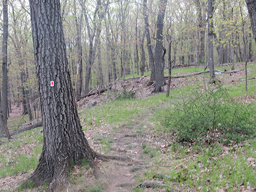
About 500 feet from the start, you’ll notice three red-on-white blazes on either side of the trail, which mark the start and end of the Old Cedar Trail. Turn left, leaving the gravel road, and follow the red-on-white blazes. The Old Cedar Trail now proceeds through an oak-beech forest, passing the concrete foundation of a former park building on the left. It soon crosses the wide route of the blue-blazed Rocky Ridge Trail, continues through a low area with abundant surface roots, and recrosses under the power lines.
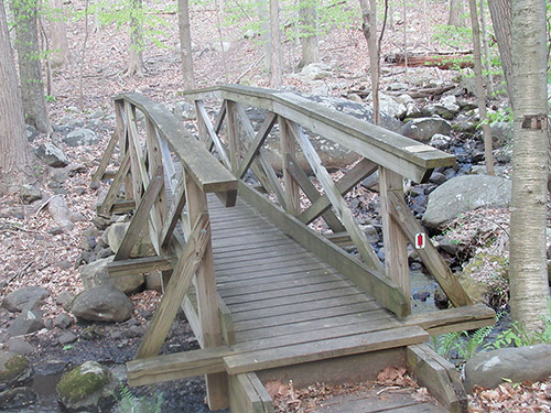
After crossing the park entrance road diagonally to the right, the Old Cedar Trail proceeds between the park entrance road on the right and I-287 on the left. It crosses several wet areas on wooden bridges and goes over a low stone wall, then loops back to the park entrance road. Here, the silver-on-white-blazed Silver Trail begins on the left, but you should continue ahead on the red-on-white blazed Old Cedar Trail, which crosses the paved road and goes over an intermittent stream on a wooden footbridge. After a short climb, it bears right, then curves to the left and again passes under the power lines.
A short distance beyond, the green-blazed Beeches Trail proceeds straight ahead, but you should turn sharply left, following the red-on-white blazes of the Old Cedar Trail. You’ve now left the developed portion of the park, and the trail begins a steady, gradual ascent. It crosses a stream and turns left to parallel it. Soon, the trail bears right, away from the stream, and continues its winding, gentle ascent. Along the way, you’ll pass the western trailhead of the Silver Trail (the junction is marked by a large cairn).
As you reach the crest of the ridge, the blue-blazed Rocky Ridge Trail briefly joins from the right. When the two trails diverge, bear left to continue on the red-on-white-blazed Old Cedar Trail, which begins to descend. After leveling off and winding along the backslope of Campgaw Mountain, it again climbs to the summit ridge.
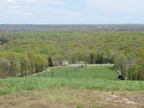
As it nears the crest of the ridge, the Old Cedar Trail crosses two stone walls. Just beyond, a building at the top of the ski area may be seen through the trees on the right, and the yellow-blazed Backslope Trail begins on the left. Turn right here and follow a blue/red-on-white-blazed connector trail to an expansive east-facing viewpoint at the top of the ski slope. To the left are the hills of Harriman Park, and in the center is northern Bergen County, with Mahwah in the foreground. The Palisades can be seen on the horizon. This is a good place to take a break.
After you’ve rested a little and enjoyed the view, return to the trail on the southwest side of the clearing. Turn right and retrace your steps along the blue/red-on-white-blazed connector trail, which heads northwest. When you reach the end of the blue/red connector trail, turn right and rejoin the red-on-white-blazed Old Cedar Trail, which curves to the east and descends gradually. In about half a mile, it reaches the northwest corner of the large parking lot for the ski area. The trail turns left and follows the stone curbing along the edge of the parking lot and the entrance road.
Near the merge of the exit road from the parking lot, the trail bears left, reenters the woods and descends along the hillside. It turns left and crosses Fyke Brook on a wooden bridge. The Old Cedar Trail then curves left, bears right and gradually ascends to reach a junction with the pink-blazed Dogwood Lane Trail.
Bear right and follow the joint Old Cedar/Dogwood Lane Trail, which parallels a stone wall on the left. After crossing the paved ski area access road, it follows a wide path parallel to the park entrance road, with Fyke Pond visible through the trees on the right. In about 500 feet, you’ll reach a complex trail junction, marked by several signs. Turn sharply left here and follow the pink-blazed Dogwood Lane Trail for 300 feet to the park entrance road. Continue across the road to the main parking area and turn right to reach the southern end of the parking area where you began the hike.
By Daniel D. Chazin
�