This 4.5-mile moderate “lollipop-loop” hike in nearby Ramapo Mountain State Forest climbs to several viewpoints and follows the shore of scenic Ramapo Lake. The hike should take about three hours. Dogs are allowed on leash.
To reach the trailhead, take N.J. Route 4 West to Route 208 North, and follow Route 208 to its end. Continue ahead on I-287 South, and take Exit 57 (Skyline Drive). Bear right at the fork and proceed north on Skyline Drive for a short distance. Just ahead on the left is the lower Ramapo Mountain State Forest parking area. Turn left into the parking area. NOTE: This parking area fills up very early on weekends, so it is preferable to do this hike on a weekday.
At the southern end of the parking area, a triple black-square-on-blue blaze marks the start of the Ramapo Lake Spur. Follow the trail into the woods, passing stone ruins. After going up a steep pitch, the trail continues to climb on a wide, rocky path, paralleling a cascading brook.
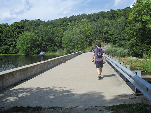
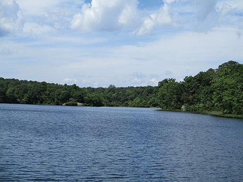
As you approach the crest of the rise, you’ll cross a stream on rocks. A short distance beyond, the white-blazed Castle Loop joins from the right. Just ahead, the trails bear left at a fork and descend to a trail junction at Ramapo Lake, where the Ramapo Lake Spur ends (there are street signs at the junction for South Shore Drive, North Shore Drive and Rye Cliff Road). Here, you should turn left, crossing the dam of Ramapo Lake.
On the other side of the dam, a triple blue-on-white blaze marks the start of the Ramapo Lake Loop. Just ahead, a sign and three red blazes mark the start of the Lookout Trail (now known as the LeGrande Hill Loop). On the right, the other end of the LeGrande Hill Loop is marked by three red-on-white blazes on a tree. Continue ahead for 500 feet on the joint Ramapo Lake Loop/LeGrande Hill Loop, then turn left onto the red-on-white-blazed LeGrande Hill Loop, which begins to climb. Soon, it reaches a viewpoint over the Wyanokie Mountains, with Ramapo Lake visible through the trees on the right. The trail now makes a brief, but steep, descent, then levels off. After climbing a little, it reaches a second viewpoint from a rock ledge, with the view largely obscured by vegetation.
About three-quarters of a mile from the dam, you’ll reach a junction where the LeGrande Hill Loop turns left. Here, the red/blue-on-white-blazed LeGrande-Lake Connector begins. Leave the LeGrande Hill Loop and proceed ahead on the LeGrande-Lake Connector. You’ll immediately reach a large rock expanse, with limited views to the west. The Wyanokies are on the horizon.
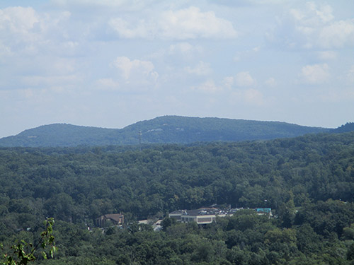
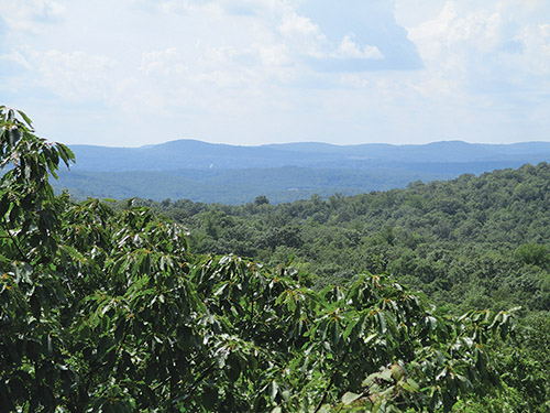
The LeGrande-Lake Connector now begins a steady descent, steep in places. On the way down, it passes a south-facing viewpoint over Pompton Lake. After a short climb, the trail reaches a panoramic viewpoint from a large open rock ledge, with High Mountain visible to the south beyond I-287.
The trail now descends to cross a stream, then climbs to a junction with an old paved estate road. It turns right and follows the road, which soon becomes surfaced with gravel. This road is a welcome contrast to the rocky paths that you have followed for much of the way.
In a quarter mile, after descending a little, the LeGrande-Lake Connector ends at a T-intersection with the blue-on-white-blazed Ramapo Lake Loop. Bear left onto the Ramapo Lake Loop, which follows a gravel road around Ramapo Lake. In another 300 feet, bear right at a Y-intersection as the Cannonball Trail, marked by white-“C”-on-red blazes, joins from the left.
You now head north through dense vegetation, paralleling the western shore of Ramapo Lake. At first, the road runs some distance from the water, but after a while, the lake can be seen through the trees. In half a mile, you’ll pass a building on the hillside to the left (formerly used as a ranger station) and, a short distance beyond, a rock ledge to the right of the trail offers a pleasant view of the lake.
Soon, another gravel road joins from the left. Follow the road ahead, crossing a stone causeway that isolates a quiet pond on the left from the main body of the lake. Next, you’ll reach another Y-intersection. Here, the Cannonball Trail turns left onto an intersecting gravel road (also the route of the orange-blazed Wanaque Ridge Trail, which begins here), but you should bear right and continue to follow the blue-on-white blazes. A short distance ahead, you’ll notice a triple-blue blaze on the right. Follow this blue-blazed side trail for 500 feet to a rock outcrop overlooking the lake. After taking in the view, return to the Ramapo Lake Loop and turn right.
After passing a small, abandoned stone building to the right, you’ll come to another intersection. Here, you should bear right, once more joining the white-blazed Castle Loop.
Follow the white and blue-on-white-blazed gravel road that runs close to the shore along the northern end of the lake, passing a viewpoint over the lake from a rock ledge on the right. Soon, you’ll pass a private residence on a ledge to the left. At the end of the lake, a triple blue-on-white blaze marks the end of the Ramapo Lake Loop. Continue ahead to a T-intersection with street signs, proceed through a gap in the guardrail, and continue along the black-square-on-blue-blazed Ramapo Lake Spur, retracing your steps back to the parking area where the hike began.
This hiking article is provided by Daniel Chazin of the New York-New Jersey Trail Conference. The Trail Conference is a volunteer organization that builds and maintains over 2,000 miles of hiking trails and publishes a library of hiking maps and books, including a two-map set for North Jersey Trails ($10.95). The Trail Conference’s office is at 600 Ramapo Valley Road (Route 202), Mahwah; (201) 512-9348; www.nynjtc.org. Daniel Chazin can be reached at [email protected].