This 6.5-mile moderate hike in the Black River County Park in Chester, New Jersey, traverses the wild and scenic gorge of the Black River, which features some of the most spectacular scenery in the state. It passes several historic buildings, including the ruins of a stone building by a waterfall in the river gorge, and follows the route of a railroad abandoned over a century ago. Dogs are permitted on leash. The hike should take about four hours (possibly a little longer, if you wish to linger and admire the scenery in the gorge). A map is available online at www.morrisparks.net/index.php/parks/cooper-gristmill�
To reach the start of the hike, take I-80 West to Exit 27A and continue south on U.S. Route 206 for 8.0 miles. Turn right onto County Route 513 (formerly designated as N.J. Route 24) and follow it for 1.2 miles to the entrance to Cooper Mill Park, on the left.
From the northwest corner of the parking area, proceed west to the stone Cooper Mill, built in 1826. Descend the stairs alongside the mill and continue south on the blue-blazed spur of the Patriots’ Path (blazed with the path-and-tree logo), which crosses several tributary streams on wooden bridges and several wet areas on puncheons. About a third of a mile from the start, the trail turns left onto an abandoned railroad grade—the former route of the Hacklebarney Branch of the Central Railroad of New Jersey, built in 1873 to carry iron ore from mines along the river and abandoned in 1900. The trail follows this railroad grade for the next mile. Although it was abandoned over a century ago, the right-of-way is in remarkably good condition.
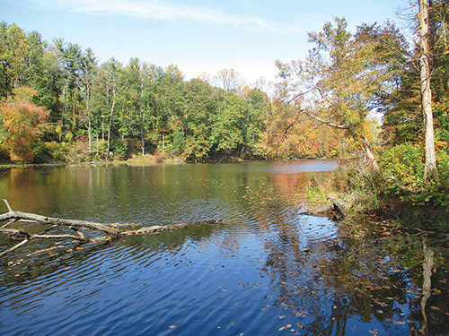
Half a mile from the start, you’ll pass Kay Pond (formerly known as Hacklebarney Pond) on the right. Here, the railroad had to be blasted through a rock cut, and the drill marks from the blasting may still be seen in the rock. The small building at the south end of Kay Pond was once used to store ice cut from the pond in the winter.
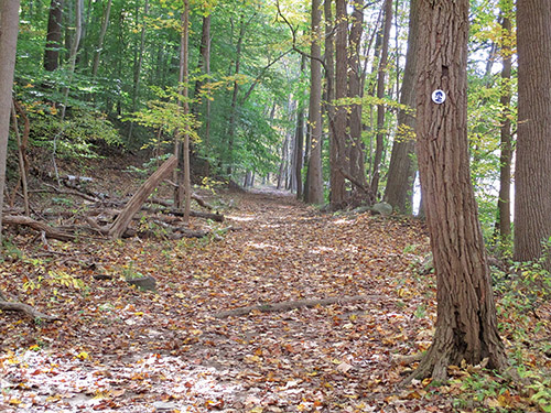
After passing the stone dam at the end of the pond, the trail goes by a bridge over the Black River (closed to vehicular traffic), turns left, and passes a fenced-in area on the left. This is the site of the former Hacklebarney Mine, where a considerable amount of iron ore was mined in the last quarter of the 19th century. The trail proceeds along the scenic river. Soon, the railroad grade ends and the trail continues on a slightly rougher footpath parallel to the river.
About 1.2 miles from the start, after crossing two wooden footbridges over tributary streams, the trail reaches abandoned concrete abutments in the river—the remnants of a former bridge. Here, the trail bears left and begins to head uphill on a wide woods road. It passes the start of the Green Trail on the right and bears left at the next fork. (The right fork is the route of the Blue/Orange Trail.) Soon, the trail begins to parallel Chubb Brook (below on the left). The trail now curves right and continues to climb more steeply.
At the top of the climb, the trail reaches a junction in a clearing, marked by signposts. Here, the Yellow Trail joins briefly. Turn left to continue on the Patriots’ Path, then immediately turn left at the next intersection. After passing the start of the White Trail on the right, you’ll continue along open fields and reach a parking area, with the Kay Environmental Center on the right.
Pass just to the left of the Environmental Center (note a Patriots’ Path blaze on a tree to the left of a fence) and continue on a wide grassy path between fields, which becomes a grassy woods road. The Patriots’ Path turns left at a T-intersection (the Orange Trail begins on the right), then bears right to join the paved entrance road. It continues along the road for a quarter mile, then turns right onto Pottersville Road. After following Pottersville Road for 750 feet, the trail turns left (opposite 230 Pottersville Road) and reenters the woods on a footpath. It continues through dense underbrush.
In another quarter mile, after bearing right at a junction, the trail begins a gradual climb of the hillside. After crossing an old woods road diagonally to the left, it continues uphill on a rocky path, soon reaching the top of the hill. The trail now descends to a junction with the red-blazed Conifer Pass Trail (marked by signposts). Turn right and follow the red-blazed trail as it descends to recross Pottersville Road.
On the other side of the road, the trail descends through a mixed evergreen and deciduous forest, crossing several old stone walls along the way. At the base of the descent, it crosses Cedar Brook on rocks. The trail ascends rather steeply on switchbacks, continues climbing more gradually to the crest of the rise, then descends to the Black River, passing two mine pits on the right.
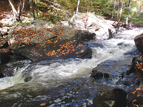
The red-blazed trail now heads north through the rocky gorge of the Black River, running directly along the river. This wild and spectacular section of the river is the scenic highlight of the hike, but the trail is narrow and runs along the steep hillside, so take care as you traverse this portion of the trail. This is a good place to take a break and enjoy the beauty of the cascading river.
After about a quarter of a mile, the trail begins to climb out of the gorge. At the top of the climb, it reaches a T-intersection. Here, the red-blazed trail turns right, but you should turn left, now following the Green Trail. The Green Trail descends on a woods road, passes a stone chimney and stone foundations on the left, and levels off along the river. Soon, it climbs to reach another T-intersection, where you should turn left, continuing to follow the Green Trail.
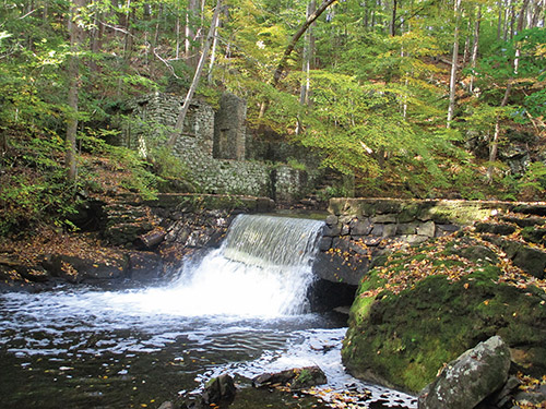
Once again, the trail descends to the river and continues along another wild and scenic section of the river, with cascades and rapids. Soon, you’ll pass the stone abutments of a former bridge and reach a curved stone dam, with the ruins of a large stone building on the opposite side of the river.
Continue along the Green Trail, which soon begins to follow a level woods road. The Green Trail crosses the Orange Trail and continues to its terminus at the Patriots’ Path. Turn left and follow the Patriots’ Path north along the Black River for 1.2 miles, retracing your steps to the Cooper Mill parking area where the hike began.
This hiking article is provided by Daniel Chazin of the New York-New Jersey Trail Conference. The Trail Conference is a volunteer organization that builds and maintains over 2,000 miles of hiking trails and publishes a library of hiking maps and books. The Trail Conference’s office is at 600 Ramapo Valley Road (Route 202), Mahwah; (201) 512-9348; www.nynjtc.org. Daniel Chazin can be reached at [email protected].