


This 3.5-mile moderate hike traverses the Apshawa Preserve, a rugged 576-acre tract owned by Passaic County and the New Jersey Conservation Foundation, with about seven miles of trails. This hike features the trails in the northern section of the preserve, looping around the Butler Reservoir. The trails are marked with paint blazes and with colored plastic diamond blazes that incorporate the logo of the New Jersey Conservation Foundation. (The trails used on this hike are primarily marked with paint blazes.) The hike should take about three hours. Dogs are allowed on leash. A map is available online at www.njconservation.org/wp-content/uploads/2018/11/ApshawaTrailMap.pdf.
To get there, take Route 4 West to Route 208, and continue on Route 208 to I-287 South. Take Exit 53 (Bloomingdale) and turn left onto Hamburg Turnpike. Upon entering Bloomingdale, the name of the road changes to Main Street. When you reach a fork in 1.3 miles (from Route 287), bear right, but at the next fork (in another 0.1 mile), bear left to continue on Hamburg Turnpike. Follow Hamburg Turnpike for another 1.3 miles, then turn right onto Macopin Road. In 1.9 miles, turn left onto Northwood Drive. Proceed for 500 feet and turn right into the parking area for the Apshawa Preserve. GPS address: 4 Northwood Drive, West Milford, NJ 07480. The trailhead is 25 miles from Teaneck, and it should take about 30 minutes to get there.
The hike begins at the northern end of the parking area. Go through a gate in a deer fence and follow the Blue Trail, which first proceeds along a woods road, but continues on a footpath. After crossing a wet area on puncheons, the Blue Trail bears left and descends to cross a stream. It then climbs a hill on a woods road, passing on the left the start of the Purple Trail. Continue ahead on the Blue Trail, which bears right at a high point and passes interesting rock formations on the left. Just beyond, the trail turns left, leaving the woods road, climbs over a rise and descends steeply into a ravine, where it turns left onto another woods road.
A short distance ahead, you’ll notice white blazes on a rock to the right. Turn right, leaving the Green Trail, and follow the White Trail, which soon begins to climb. At the top of the hill, you’ll pass through an area studded with cedars and soon reach a west-facing viewpoint, with the Butler Reservoir visible below. You’ll be hiking along the shoreline of this reservoir later on in the hike.
The trail now descends rather steeply to the southeast corner of the reservoir. Here, the White Trail goes through a gate in a deer fence and ends at a junction with the Red Trail. Turn right onto the Red Trail, which heads north parallel to the eastern shore of the reservoir, with views over the reservoir.
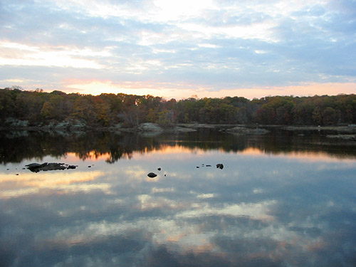
At the northern end of the reservoir, the Red Trail bears right, briefly follows a stream, and reaches a junction with the Yellow Trail. Turn left and continue on the Red Trail, which crosses a dam over a small pond and continues on a woods road. At a second junction with the Yellow Trail, follow the Red Trail as it turns left onto a footpath and soon rejoins the woods road. In a short distance, you’ll reach an open area to the left of the trail that affords a south-facing view over the Butler Reservoir, with several beaver dams visible in the reservoir.
After traversing a wet area, the trail crosses the wide inlet stream of the reservoir on a metal bridge. The trail now heads east, soon reaching the shore of the reservoir. It heads south parallel to the shore, soon passing a rock ledge that affords a nice view over the reservoir. Just beyond, the trail climbs briefly to avoid a steep rock face, but for most of the next half mile, the trail closely parallels the shore of the scenic reservoir. At one point, an unmarked trail on the left leads to a large rock outcrop overlooking the reservoir.
After several private homes come into view (on the right) near the southwest corner of the reservoir, the trail crosses some wet areas and turns left onto a woods road. A short distance beyond, a gravel road on the left leads to a secondary dam, with views over the reservoir. The Green Trail soon joins from the right, and you should follow both red and green blazes along the road.
Be alert for a right turn, where the Red and Green Trail turn right and descend. (If you want a final panoramic view over the reservoir, continue ahead to the dam.) A short distance ahead, the trails cross Apshawa Brook on a metal bridge just below the dam of the reservoir. (Due to safety concerns, the historic stone dam has been breached and a concrete spillway constructed to lower the water level of the reservoir.)
On the other side of the bridge, follow the Green Trail as it turns right and goes through a gate. The Green Trail loops around and soon reaches a junction with the Blue Trail, which begins on the left. Turn left onto the Blue Trail and follow it all the way back to the parking area, where the hike began.
This hiking article is provided by Daniel Chazin of the New York-New Jersey Trail Conference. The Trail Conference is a volunteer organization that builds and maintains over 2,000 miles of hiking trails and publishes a library of hiking maps and books. The Trail Conference’s office is at 600 Ramapo Valley Road (Route 202), Mahwah; (201) 512-9348; www.nynjtc.org. Daniel Chazin can be reached at [email protected]