


This 3.5-mile hike climbs on a moderate grade to the top of Campgaw Mountain, which offers a sweeping view of Bergen County and the hills of Harriman State Park. It then descends the little-used backslope of the mountain to reach two historic stone cisterns before climbing back to the crest of the ridge and returning to the trailhead. The hike involves a total elevation gain of about 750 feet, and it should take about two and one-half hours. A free trail map is available online at www.nynjtc.org/map/campgaw-mountain-brochure-map.
To get to the park, take N.J. Route 4 West to Route 208 North, and follow Route 208 for 8.5 miles to the Summit Avenue exit in Franklin Lakes. Turn left at the end of the ramp, following the sign for Franklin Lakes. At the next traffic light, turn left onto Franklin Avenue, and at the following traffic light, turn right onto Pulis Avenue. Follow Pulis Avenue for 1.5 miles and turn left onto Campgaw Road. In 1.6 miles, turn left onto the entrance road leading into Campgaw Mountain Reservation. At a fork in the road after 0.4 mile, bear left and continue for another 0.2 mile, then turn left and park at the southern end of the main parking area, near two portable restrooms. GPS address: 200 Campgaw Road, Mahwah, NJ 07430. The park is about 20 miles from Teaneck, and it should take about 25 minutes to get there.
From the southern entrance to the parking area, proceed west, crossing the park entrance road. You’ll notice three blue blazes on a pole to the right of a chained-off gravel road. These blazes mark the start of the blue-blazed Rocky Ridge Trail, which you’ll be following for the first part of the hike.
Just ahead, the Rocky Ridge Trail splits into two branches. To follow the trail in the clockwise direction, turn left, leaving the gravel road, and follow a blue-blazed footpath through a wooded area. The trail goes to the right of a park building and crosses a grassy area, passing under high-voltage power lines. At a yellow gate, follow the blue blazes as the Rocky Ridge Trail descends to cross the red-on-white-blazed Old Cedar Trail. After passing a swampy area to the left, the Rocky Ridge Trail ascends along a wide woods road, which parallels the route of an abandoned bobsled run. Halfway up the hill, the green-blazed Beeches Trail crosses. Just beyond, you’ll notice (on the right) old machinery formerly used to make snow for the bobsled run.
In about half a mile, as it approaches the ridge, the Rocky Ridge Trail bears right and climbs on a broad switchback. At the crest of the ridge, it crosses the red-on-white-blazed Old Cedar Trail. Here, you should turn left and follow the red-on-white blazes of the Old Cedar Trail, which begins to descend on a rocky footpath. After leveling off and winding along the backslope of Campgaw Mountain, it again climbs to the summit ridge.
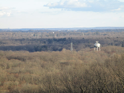
As it nears the crest of the ridge, the Old Cedar Trail crosses two stone walls. Just beyond, a building at the top of the ski area may be seen through the trees on the right, and the yellow-blazed Backslope Trail begins on the left. Turn right here and follow a blue/red-on-white-blazed connector trail to an expansive east-facing viewpoint at the top of the ski slope. To the left are the hills of Harriman Park, and in the center is northern Bergen County, with Mahwah in the foreground. The Palisades can be seen on the horizon. This is a good place to take a break.
When you’re ready to continue, retrace your steps along the connector trail to the junction. Here, you should bear left onto the yellow-blazed Backslope Trail, which descends the western slope of the mountain on a woods road. Soon, it bears left, leaving the woods road, and continues to descend on a footpath. After turning sharply right, the trail levels off, then continues to descend. It briefly levels off once more, and soon passes a large stone foundation on the left. This is actually an old cistern, which once served as the water supply for a home below. It is often dry, but may contain water during wet periods. The trail continues on a relatively level footpath, then switches back to the left and resumes its descent.
At the base of the descent, you’ll notice another old stone cistern (this one is usually filled with water) just below the trail, with Ramapo Valley Road visible beyond through the trees. Here, the Backslope Trail turns sharply right and begins a steady climb towards the summit of the mountain. On the way, you’ll go through a narrow passage between two huge trees that fell in opposite directions, pass an interesting misshapen tree, go under a tree trunk that arches over the trail, and pass a huge oak tree with three trunks (a fourth trunk, which fell in the fall of 2016, may be seen on the ground next to the tree).
At the top of the climb, the yellow-blazed Backslope Trail ends at a junction with the red-on-white-blazed Old Cedar Trail. Turn left and follow the Old Cedar Trail as it curves to the east and descends gradually, passing through an area where many trees were felled by Hurricane Sandy in October 2012. In half a mile, it reaches the northwest corner of the large parking lot for the ski area. The trail turns left and follows the stone curbing along the edge of the parking lot and the entrance road.
Just before the merge of the exit road from the parking lot, the Old Cedar Trail bears left, reenters the woods, and descends along the hillside. It turns left and crosses Fyke Brook on a wooden bridge. The trail then bears right, and gradually ascends to reach a junction with the pink-blazed Dogwood Lane Trail, which comes in from the left.
Turn right and follow the joint Old Cedar/Dogwood Lane Trail, which parallels a stone wall on the left. After crossing the paved ski area access road, it follows a wide path parallel to the park entrance road, with Fyke Pond visible through the trees on the right. In 700 feet, you’ll reach a complex trail junction. Turn sharply left here and follow the pink-blazed Dogwood Lane Trail for 300 feet to the park entrance road. Continue across the road to the main parking area and turn right to reach the southern end of the parking area, where you began the hike.
This hiking article is provided by Daniel Chazin of the New York-New Jersey Trail Conference. He can be reached at [email protected].