
Moshe designated three cities on the eastern side of the Jordan River as Cities of Refuge (Devarim 4:41-43) and commanded the nation to designate three more on the western side after they conquer Canaan (19:1-7), adding that if/when they keep the Torah properly, and God expands the borders as He promised our ancestors, they should add another three (19:8-9). The commentators (e.g. Rashi, Rashbam and Ramban) explain that this expansion refers to God’s promise to Avraham (Bereishis 15:18-21), whereby the land of all 10 nations mentioned there would become part of the Land of Israel and not just the land of the seven nations of Canaan.
Although the Euphrates River is one of the boundaries of the Promised Land mentioned to Avraham and at Sinai (Shemos 23:31 and Devarim 1:7), as well as in the instructions to conquer the land (Devarim 11:24 and Yehoshua 1:4), it isn’t included in the specific boundaries in Bamidbar (34:1-15). Malbim (Bamidbar 34:1) explains that the boundaries in Bamidbar delineate the initial area to be conquered, while the other descriptions refer to expanded boundaries to be added after the nation’s population grows and there’s no longer a concern about wildlife overtaking sections meant to eventually become part of the Promised Land. Yoel Elitzur (“Places in the Parasha,” Mishpatim) echoes this suggestion, and includes a map showing what was included in the initial boundaries and what was supposed to be added (although I’m not sure it’s fully accurate).
The expansion referred to by Malbim is not the same expansion that triggers additional Cities of Refuge. The final three Cities of Refuge are supposed to be added after Moshiach comes, when the land of the additional three nations included in the promise to Avraham become part of the Land of Israel, whereas the expanded borders the Malbim refers to apply after the area within the borders specified in Bamidbar has been conquered, and the population grows enough to warrant conquering the rest of the land of the seven Canaanite nations. Therefore, there are three stages: (1) the land to be conquered by Yehoshua right away i.e. the specific borders described in Bamidbar; (2) the expanded borders i.e. those mentioned in Devarim 11:24 and Yehoshua 1:4, which are to be conquered after the population grows and there’s no longer a concern that uninhabited land will be taken over by wildlife; and (3) after Moshiach comes, when the lands of the Keini, Kenizi and Kadmoni are added i.e. the land referred to in Bereishis and at Sinai. [I have included both descriptions at Sinai in the third stage based on the assumption that had Moshe entered the land, the Messianic era would have begun. Although Chizkuni (Devarim 1:7) equates the two descriptions at Sinai, the one in Shemos was given before the sin of the Golden Calf, while the one in Devarim was given afterward, so it’s theoretically possible that things changed after the Golden Calf, even though the sin of the scouts hadn’t occurred yet. Although Malbim includes the descriptions given at Sinai in the second stage, they most likely refer to the third stage.]
The northern border doesn’t seem to change between the second and third stages, but it does change between the first and second stages (which is why the Euphrates isn’t mentioned in Bamidbar but is included in the others). How much the southern border changes depends on which “desert” is being referred to, as well as what the three additional nations are (see Bava Basra 56a). This also impacts how (and if) the eastern boundary changes.
In Bamidbar, the northern border starts at the Mediterranean Sea (34:7), goes to the northern Hor HaHar (not to be confused with the Hor HaHar near Edom), continues to Levo Chamus (34:8), followed by three additional boundary markers (34:8-9), without reaching the Euphrates. The locations of Hor HaHar and Levo Chamus are a matter of discussion; some place them parallel to the southern edge of Cyprus, while others place them close to the northernmost part of the Mediterranean coastline, well north of Cyprus. Either way, they weren’t conquered in Yehoshua’s lifetime (see Yehoshua 13:5), and may have never been conquered, despite Divrei Hayamim I 13:5 implying that they were (see page 136/140 of “Atlas Daat Mikra”).
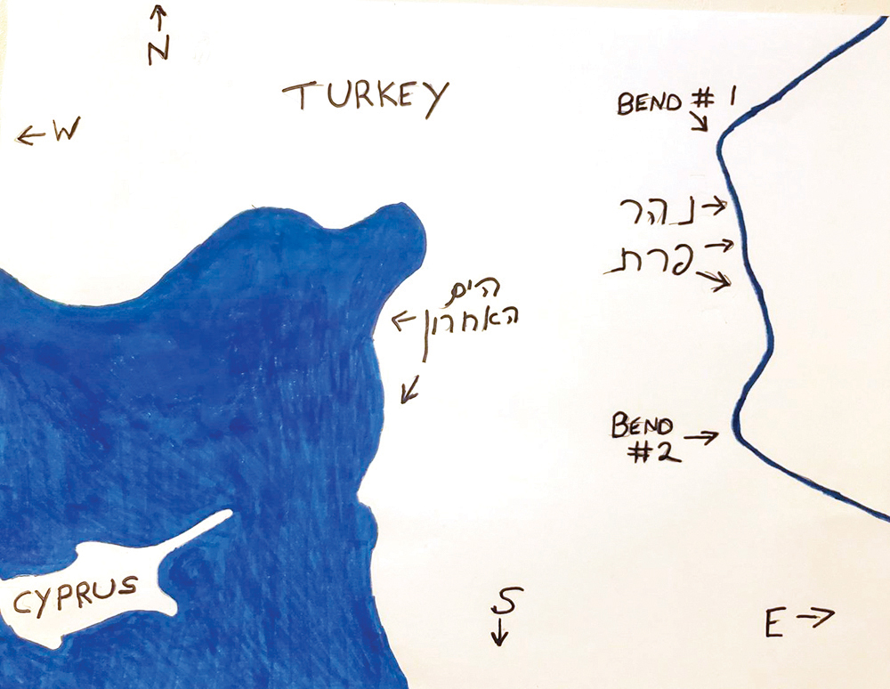
The Euphrates, which starts in Turkey and, for most of its length, flows southeast before emptying into the Persian Gulf, actually flows southwest for a stretch before reaching a point almost parallel to the northeastern tip of the Mediterranean coastline. It then bends and flows (basically) south until it reaches a point parallel to the northeastern tip of Cyprus, when it bends again (in the opposite direction) and starts the long stretch of its southeastern flow into the Persian Gulf. When the Torah gives the Euphrates as the northern border of the Promised Land (Bereishis 15:18, Shemos 23:31 and Devarim 1:7), it would seem to be referring to one of these two bends (depending on where Hor HaHar is). Since Avraham was promised “this land,” the Mediterranean Sea was obviously the western boundary, and there was no need to point this out. How far north along the Mediterranean did “this land” extend? Until this part of the Euphrates River.
As mentioned, the instructions for Yehoshua (Devarim 11:24) include the boundaries of the second stage. Like the third stage, the Euphrates is the northeastern point of the northernmost section, a section that either stretches from the Mediterranean to the southern-flowing section of the Euphrates (between the two bends), or whose northern border goes from the Mediterranean to the second bend (before the river starts flowing southeast). After giving the south-north boundaries of the second stage (the desert and the Levanon), the extent of the northern section is given — from the Mediterranean Sea to the Euphrates River.
Rabbi Dov Kramer is convinced that Chiram, the Phoenician King of Tyre, was so friendly and cooperative with King David and King Solomon, including providing much of the raw material for Solomon’s Temple, because he knew that his land was within the intended boundaries of even the first stage, successfully prolonging his autonomy.