
This moderate three-mile loop hike in Long Pond Ironworks State Park in West Milford follows the Burnt Meadow Loop. It runs along the ridge of Horse Pond Mountain, passing some interesting glacial erratics, and reaches several panoramic viewpoints, including one from which the entire Monksville Reservoir can be seen. The hike involves a total elevation gain of about 600 feet, and it should take about 2 1/2 hours to complete the loop. Dogs are permitted on leash.
To get there, take N.J. Route 4 West and continue on N.J. Route 208 West, which becomes I-287 South. Take Exit 57 and turn right onto Skyline Drive. Continue on Skyline Drive to its northwestern terminus at Greenwood Lake Turnpike (County Route 511). Turn right onto Greenwood Lake Turnpike and continue for 5.8 miles to Burnt Meadow Road (Burnt Meadow Road is about one mile beyond the crossing of the Monksville Reservoir). Turn left onto Burnt Meadow Road and proceed for about 1.5 miles (passing Camp Shiloh on the right). Just before reaching a kiosk on the right, you’ll notice a small roadside parking area on the left. Park here. The trailhead is about 30 miles from Teaneck and it should take about 40 minutes to get there. GPS address (approximate): 650 Burnt Meadow Road, West Milford, New Jersey 07480.
The hike begins at the kiosk on the west side of the road. Here, the green-blazed Burnt Meadow Loop enters the woods and begins to climb gradually. After reaching the crest of the rise, the trail descends gently to reach a junction with the blue-blazed Tapawingo Trail, which joins from the left. Continue ahead on the joint green/blue trail, descending gently. After crossing a woods road, the blue-blazed Tapawingo Trail leaves to the right. Bear left at the junction to continue along the green-blazed Burnt Meadow Loop, which descends to cross Hewitt Brook on rocks. This crossing can be difficult if the water is high.

On the other side, the trail climbs away from the stream and bears right to follow the contour of the hill. After crossing a small stream, the trail begins a rather steep climb to a rock ledge with a limited east-facing view over Horse Pond Mountain (you’ll be following the ridge of this mountain later in the hike). Here, the Burnt Meadow Trail reaches a second junction with the blue-blazed Tapawingo Trail.
Turn right and follow the joint green/blue trail, which continues to climb. Soon, on the right, you’ll pass a large glacial erratic formed of puddingstone — a type of rock not characteristic of this area. The trail now descends to a valley, climbs over a slight rise and soon levels off.
After passing a huge boulder on the left, the joint green/blue trail enters a pine grove and begins to descend. It descends steadily until it reaches a T-intersection. Here, it turns right for 50 feet to reach a junction where the trails diverge. Turn left and follow the green-blazed Burnt Meadow Loop, which descends to cross two branches of Hewitt Brook on rocks (this crossing, too, can be tricky during wet seasons).
The trail continues along a dirt road under power lines out to Burnt Meadow Road, passing to the right of a transformer station. It crosses the road diagonally to the right, reenters the woods and climbs to reach a junction with the teal-diamond-blazed Highlands Trail.

Turn right and begin to follow both green and teal diamond blazes. The trail now climbs along the crest of the ridge of Horse Pond Mountain, soon reaching a rock outcrop with a view over Monks Mountain to the east, and views through the trees of the Monksville Reservoir (when there are no leaves on the trees).
Beyond the rock outcrop, the trail levels off. After climbing a little, it reaches a junction with the green-on-black-blazed Burnt Meadow Spur, which begins on the right and descends for 0.2 mile to Burnt Meadow Road, opposite Camp Shiloh. Continue ahead on the joint Burnt Meadow Loop/Highlands Trail.
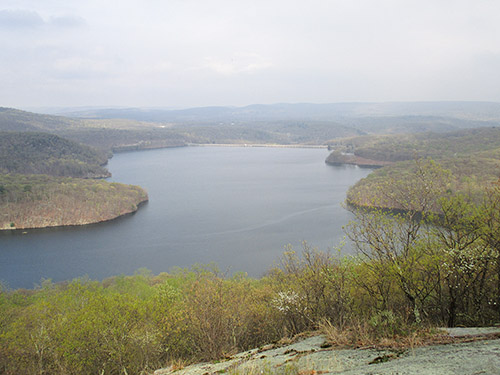
After climbing more steeply, the trail comes out on a large rock outcrop which affords a spectacular view over the Monksville Reservoir, with the dam of the reservoir ahead and the bridge that carries Greenwood Lake Turnpike over the reservoir on the left. This is the only point from which you can see the entire horseshoe-shaped reservoir. You’ll want to stop here to take a break and enjoy the view.
The trail now curves to the right and continues to climb to the summit of Horse Pond Mountain (elevation 955 feet), marked by a grassy area and an interesting balanced boulder. There are limited west-facing views from the summit.

The trail bears left and descends from the summit, then climbs slightly to reach a rock outcrop. Here, at a pine tree, the two trails diverge. Turn right and follow the green-blazed Burnt Meadow Trail, which descends very steeply over lichen-covered rocks. The grade soon moderates, and after continuing to descend on switchbacks, the trail turns left onto a woods road. Almost immediately, it turns left onto a footpath (to bypass a wet section of the road), but soon rejoins the road. In another 100 feet, the trail turns right, leaving the road, and descends on a footpath, then turns right onto another woods road.
In 200 feet, the trail turns left, leaving the second woods road, and descends to cross a stream on stepping stones. After a short climb, it briefly turns left to parallel the stream, then turns right and heads west to reach Burnt Meadow Road. The parking area where you left your car is just to the right.
This hiking article is provided by Daniel Chazin of the New York-New Jersey Trail Conference. Daniel Chazin can be reached at DChazin@aol.com.