
This moderate five-mile hike in Jenny Jump State Forest in western New Jersey climbs to several panoramic viewpoints, passes several interesting glacial erratics and descends to the scenic Ghost Lake. The hike should take about three-and-a-half hours. Dogs are permitted on leash.
To get there, take I-80 West to Exit 12 (Hope/Blairstown). Turn left at the bottom of the ramp and proceed south on County 521 for 1.1 miles to the village of Hope. Turn left at the traffic light onto County 519 (Johnsonburg Road).
Continue for 1.0 mile and turn right onto Shiloh Road. In 1.1 miles, turn right onto State Park Road and proceed for 1.0 mile to the park entrance, on the left. After stopping at the park office to obtain a map, head uphill on the road. After passing a restroom building on the left, follow the paved road as it curves to the right, and park in the paved parking area. GPS address: 330 State Park Road, Great Meadows, NJ 07838. The trailhead is about 60 miles from Teaneck, and it should take about 65 minutes to get there.

From the parking area, walk back along the paved road until you reach a T-intersection, with a sign marking the trailhead of the Summit and Swamp Trails.
Turn right onto a woods road and follow the yellow and red blazes, passing two cabins on the left. Just beyond, the road begins to climb and bears right at a fork.
After passing Campsite #9 on the right, you’ll come to a junction (marked by a signpost). Here the red-blazed Swamp Trail forks to the left. This will be your return route, but for now, bear right to continue on the yellow-blazed Summit Trail, which resumes its climb.
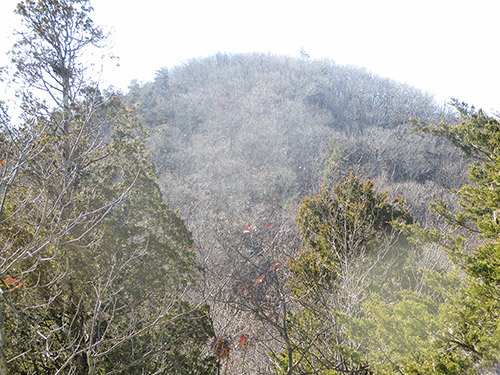
Soon, you’ll come to a flat rock along the trail. Here, a side trail to the right leads over open rocks to a panoramic viewpoint amid cedars, with farmlands of the Great Valley on the left, and the cone-shaped mountain known as The Pinnacle directly ahead. Glacial striations are clearly visible on the surface of the rock outcrop at the viewpoint.

After taking in the view, return to the Summit Trail and turn right. The trail now bears left and follows a wide, grassy path along the ridge of Jenny Jump Mountain. Soon, a side trail on the right leads to a rock outcrop with a partial view. In 200 feet, another side trail on the right leads downhill to a panoramic southeast-facing viewpoint, which includes both forest and the fertile fields of the Great Valley.
Just beyond, the trail passes two large glacial erratics in an open area. These boulders were carried here by the Wisconsin Glacier. The one on the left is formed of sandstone, which is very different from the underlying bedrock, composed of Precambrian granite gneiss.
The trail continues along the crest of the ridge, with views to the northwest through the trees on the left. Soon, you’ll reach an unobstructed view of the Delaware Water Gap and Kittatinny Mountain from a rock outcrop to the left of the trail. A bench has been placed here, offering hikers the opportunity to rest and take a break.
The Summit Trail now descends over rocks, steeply in one spot. At the base of the descent, a signpost marks an intersection with the blue-blazed Spring Trail, but you should continue to follow the Summit Trail along the ridge. A short distance beyond, you’ll notice a yellow-tipped concrete survey marker, with the notation “NJ 76” on the top. Here, a side trail leads right to a limited southeast-facing viewpoint from a rock outcrop.

Continue along the Summit Trail, which now descends. After a brief climb, it levels off. In a quarter mile, the trail bears left at a beech tree with many carved initials and climbs to a high point on the ridge. The highest point in the park (elevation 1,134 feet) is a short distance to the right of the trail.
From this high point, the trail descends steadily. Near the base of the descent, it bears left, and after a short level stretch, it reaches a T-intersection with a woods road. Here, you should turn right onto the blue-blazed Ghost Lake Trail, which comes in from the left. The trail climbs a little, passing rock outcrops on the right, then continues over undulating terrain.
At a high point, marked by a glacial erratic on the left, the trail begins a steady descent. The first part of the descent is on switchbacks, after which the trail levels off, then continues to descend rather steeply. At the base of the descent, the trail becomes a woods road. A short distance beyond, a branch road to the right leads to the remains of a former cabin, with east-facing views over Allamuchy Mountain State Park and the Pequest River valley.
As the trail continues to descend on the woods road, it approaches I-80, which may be heard and seen ahead through the trees. The trail now bends sharply right and begins to head south, away from the noisy highway. It passes several huge moss-covered rock outcrops on the left, then swings left and parallels a stream in an area covered with ferns. Upon reaching the lake, the trail continues across the lake on a gravel-covered causeway.

After spending some time at the lake (which, despite its name, is actually very attractive), retrace your steps, following the Ghost Lake Trail uphill, back to the signpost at the junction of the Ghost Lake and Summit Trails. Here, you should continue ahead on the woods road, now following both yellow and blue blazes. You’ll pass another interesting glacial erratic (which somewhat resembles an arrowhead) on the right.
Soon, the Summit and Ghost Lake Trails end at a T-intersection with the paved East Road (an access road to the park’s campsites). You should turn left and follow the paved road. A short distance ahead, a sign marks the start of the white-blazed Orchard Trail, but continue ahead along the road. Just beyond (between Campsites #34 and #35), you’ll notice another glacial erratic on the right—with a small tree growing out of the side of this huge boulder!
Just past Campsite #20 (opposite the second restroom building that you’ll pass), a woods road forks to the left. Leave the paved road and follow this dirt road, which passes Campsite #19 and the trailhead of the Spring Trail on the left. After passing Campsite #18 on the right, a signpost marks the start of the red-blazed Swamp Trail.
Continue ahead on the woods road, now following red blazes. To the left, the boulder-covered ridge you see through the trees is Jenny Jump Mountain, which you followed at the start of the hike. After passing through an evergreen grove, the road begins to descend. When you reach an intersection with the yellow-blazed Summit Trail, bear right and follow the joint Summit and Swamp Trails downhill, back to the parking area where the hike began.

This hiking article is provided by Daniel Chazin of the New York-New Jersey Trail Conference. Chazin can be reached at DChazin@aol.com.


