This moderate 6.2-mile hike loops around the scenic Kakeout Reservoir (also known as the Butler Reservoir) in Kinnelon. The hike should take about four hours, and dogs are permitted on leash. Portions of the route may be wet, especially after heavy rains, so it’s a good idea to wear waterproof hiking boots rather than sneakers on this hike.
The unusual name “Kakeout” is derived from the Dutch word for “lookout.” A variant of “Kakeout” is “Kykuit,” which is the name of the John D. Rockefeller estate in Westchester County (actually, “Kykuit” is a more accurate rendition of the Dutch word “Kijkuit”). The name is quite appropriate for this body of water, as there are quite a number of lookouts over the reservoir along the route of the hike.
To reach the trailhead from Teaneck, take Route 4 West to Route 208, and continue on Route 208 to I-287 South. Take Exit 52A-B, bear right at the fork in the ramp and continue onto Route 23 North. In 2.0 miles, take the jughandle U-turn and head south on Route 23, then take the next exit for Boonton Avenue (County 511). Proceed south on Boonton Avenue for 0.2 miles and turn right onto Kakeout Road. In another 0.2 miles, Kakeout Road makes a sharp turn to the right. Continue on Kakeout Road for 0.8 miles beyond this turn and turn right onto Cascade Way, where street parking is available. The trailhead is about 25 miles from Teaneck, and it should take about 35 minutes to get there.
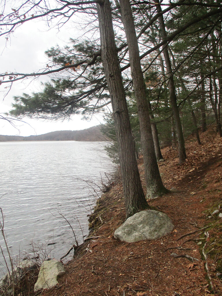
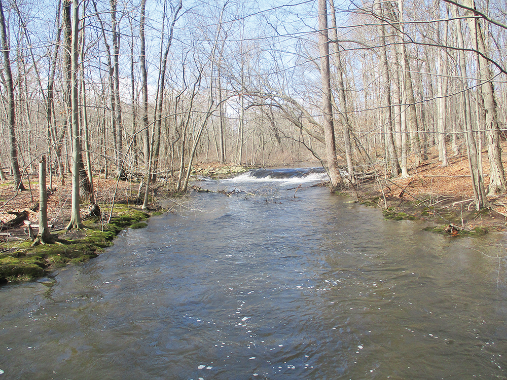
To begin the hike, return to the intersection of Cascade Way and Kakeout Road, cross Kakeout Road and continue ahead on paved Bubbling Brook Road. In about 800 feet, you’ll reach a locked gate across the road. Continue following the paved road along Stone House Brook, soon passing piles of wood chips and branches on the left. Just beyond, you’ll pass a brick building, with a breached concrete spillway across the brook. Half a mile from the start, the pavement ends at the dam of the Kakeout Reservoir. Here, the Blue-on-White Trail begins on the left and crosses the dam. This will be your return route, but for now, do not cross the dam. Continue straight ahead on a narrow footpath, the route of the Blue Trail (the start of the trail at the dam is marked with a triple blue blaze).
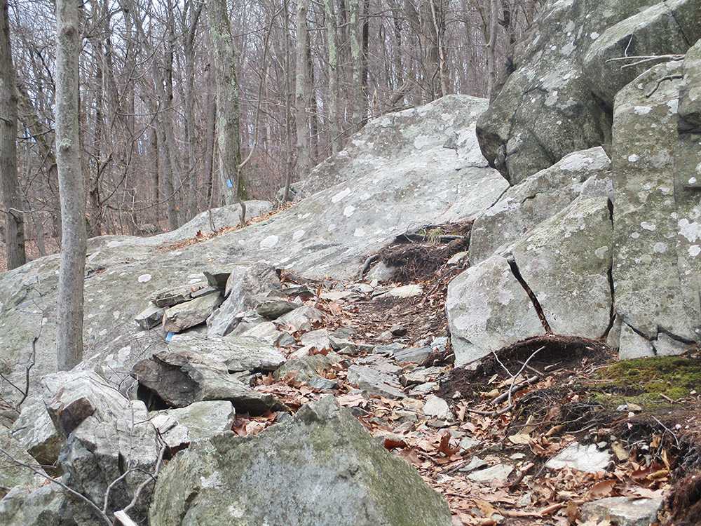
For the next mile, the Blue Trail follows close to the shore of the Kakeout Reservoir, which is dotted with white pines. This portion of the hike is particularly scenic, with a number of viewpoints over the reservoir. After following the western arm of the reservoir and climbing over an interesting rock formation, the trail briefly runs along Stone House Brook, then crosses the brook on a long wooden footbridge (with a cascade upstream from the bridge). Just beyond, it crosses several wet areas on puncheons.

About two miles from the start, the Blue Trail crosses Fayson Lakes Road. It continues along the reservoir for another third of a mile, then parallels a wetland (below on the left), with many fallen trees. After climbing a little on an old woods road, the trail turns left and descends to cross a small stream. It turns left again and proceeds through a meadow, then crosses another stream and continues along a woods road. Just before reaching a second meadow, the trail turns sharply left and climbs to Miller Road, opposite the Shepard School. (Be careful to follow the blue blazes at the second meadow, as the more obvious route curves to the right.)
The Blue Trail turns right and runs along the paved road for about 500 feet, then turns right, goes around a metal gate and descends gradually on a woods road. At the base of the descent, the trail bears left, leaving the woods road, and begins to ascend. Just ahead, the trail turns right onto a moss-covered footpath and climbs gradually to Miller Road. Here, about three miles from the start, the Blue Trail ends.
Turn right and follow Miller Road for 50 feet, then turn left onto the White Dot Trail (black dot on white). The trail passes between two houses and continues on a woods road. In 0.2 miles, the White Dot Trail makes a sharp right turn. Turn left here onto a footpath, leaving the White Dot Trail. The footpath is not blazed at the junction, but as you proceed north, it is marked with white blazes (if the blazes have been blacked out, follow the blacked-out blazes.) The footpath passes massive cliffs on the left, then curves to the right and climbs to a woods road. The trail turns left onto the woods road and follows it up to the paved Lakeview Drive.
Turn left onto Lakeview Drive and follow it for 0.2 miles, passing Brentwood Drive on the right. About 300 feet beyond the intersection with Brentwood Drive, the White Trail resumes on the left. Follow the white blazes as the trail steeply climbs a rise, turns right onto a woods road that parallels the paved road, then bears left, away from the road.
In half a mile, the White Trail crosses Fayson Lakes Road, goes around a gate, and heads north on a woods road. Soon, the trail turns left onto another woods road and approaches the shore of the Kakeout Reservoir. It crosses a dike of the reservoir (with more views over the reservoir), turns right, then bears left and reenters the woods, climbing along an old woods road. To avoid an eroded stretch of the road, the White Trail soon bears right, leaving the road, and climbs on a footpath. After descending a little, the trail rejoins the road, which ascends gradually.

At the crest of the rise, the White Trail turns left, leaving the road, and descends. It soon reaches a junction with the Blue-on-White Trail, marked with a cairn and a sign. Turn left and follow the Blue-on-White Trail downhill. After traversing a rocky area and turning right on a woods road, the trail reaches the dam of the reservoir. Turn left, cross the dam, then turn right and follow the paved road back to the intersection of Cascade Way and Kakeout Road, where the hike began.
This hiking article is provided by Daniel Chazin of the New York-New Jersey Trail Conference. The Trail Conference is a volunteer organization that builds and maintains over 2,000 miles of hiking trails and publishes a library of hiking maps and books. The Trail Conference’s office is at 600 Ramapo Valley Road (Route 202), Mahwah; (201) 512-9348; www.nynjtc.org. Daniel Chazin can be reached at [email protected].