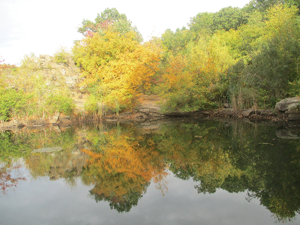
This three-mile moderate hike loops around the Cranberry Lake Preserve just north of White Plains in Westchester County, New York. It passes several scenic ponds and climbs to the rim of a former quarry. Although comprising only 190 acres, Cranberry Lake Preserve is surrounded on several sides by New York City watershed lands and is a quiet oasis in the midst of suburban Westchester County. Most of the hike is relatively level, but there are a few rather steep climbs and descents in the area of the former quarry. The hike should take about two hours. Dogs (except for service animals) are not allowed in Cranberry Lake Preserve.
Before it was acquired by Westchester County in 1967, the site had been used to quarry stone for the construction of the nearby Kensico Dam, which was completed in 1917. Remnants of this former use can be seen along the hike. Information about the preserve, including a trail map and a brochure on its history, is available at https://parks.westchestergov.com/cranberry-lake.
Trail junctions in the preserve are marked by junction numbers on small metal signs affixed to trees. These numbers are referenced in this hike description, although they do not appear on the map of the preserve.
To reach the preserve from Bergen County, cross the Tappan Zee Bridge and continue onto I-287 East. Take Exit 6 (White Plains/North White Plains). At the end of the ramp, turn left onto N.Y. Route 22. Proceed north on Route 22 for 2.9 miles and turn right onto Old Orchard Street. In 400 feet, turn right and enter the Cranberry Lake Preserve. Continue for 0.2 mile to the Nature Center. GPS address: 1609 Old Orchard Street, North White Plains, NY 10604. The preserve is about 35 miles from Teaneck, and it should take about 50 minutes to get there.
If coming from Riverdale, take I-87 North to I-287 East. Continue on I-287 to Exit 6 and follow the directions above.
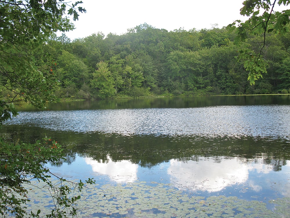
From the Nature Center, proceed south on the wide Yellow Loop, passing cliffs on the right. At junction #4, turn left, leaving the Yellow Loop. Just ahead, at junction #28, bear left again and follow an orange-blazed connector trail downhill. At junction #26 (at the shore of Cranberry Lake), turn right onto the joint Blue/Yellow Loop. After briefly following the lake shore, the trail climbs to ledges overlooking the lake, continuing to parallel it. At the end of the lake, the trail descends. After crossing a boardwalk, you’ll reach junction #6.
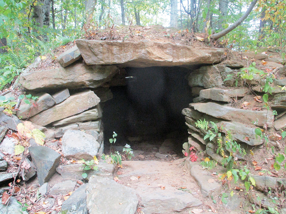
Turn left onto a wide path, passing on the right Audio Tour Stop 11, the site of a former dynamite magazine. (The information provided on the Audio Tour is also included in the history brochure available online.) Just ahead, turn left at junction #7 onto another orange-blazed trail, immediately crossing the Bent Bridge over a bog. The trail runs along old stone walls and passes the “stone chamber”—probably an old root cellar. At the end of this orange-blazed trail (junction #16), turn right onto a wide path (an old railroad bed) and follow it to a Y-intersection, with a sign for the New York City Watershed grown into a tree (junction #8).
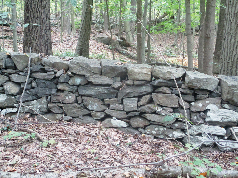
Bear left here, now following the Red Loop. On the right, marking the boundary between the park and New York City watershed lands, is an expertly laid dry stone wall, built over a century ago and still in nearly perfect condition today (except where damaged by fallen trees). Soon, the trail bears left and heads south, continuing to follow the wall.
At the southern end of the park, with private homes visible ahead through the tree, the Red Loop turns left and begins to head east. Be alert for a sharp right turn (marked by an arrow on a tree to the left) and head downhill toward Hush Pond, bearing right at the next junction and continuing to follow the Red Loop. Cross the outlet of the pond on puncheons, bear left (north), and soon begin to parallel a wetland on the left. In a short distance, you’ll join a level dirt road, with cliffs on the right.
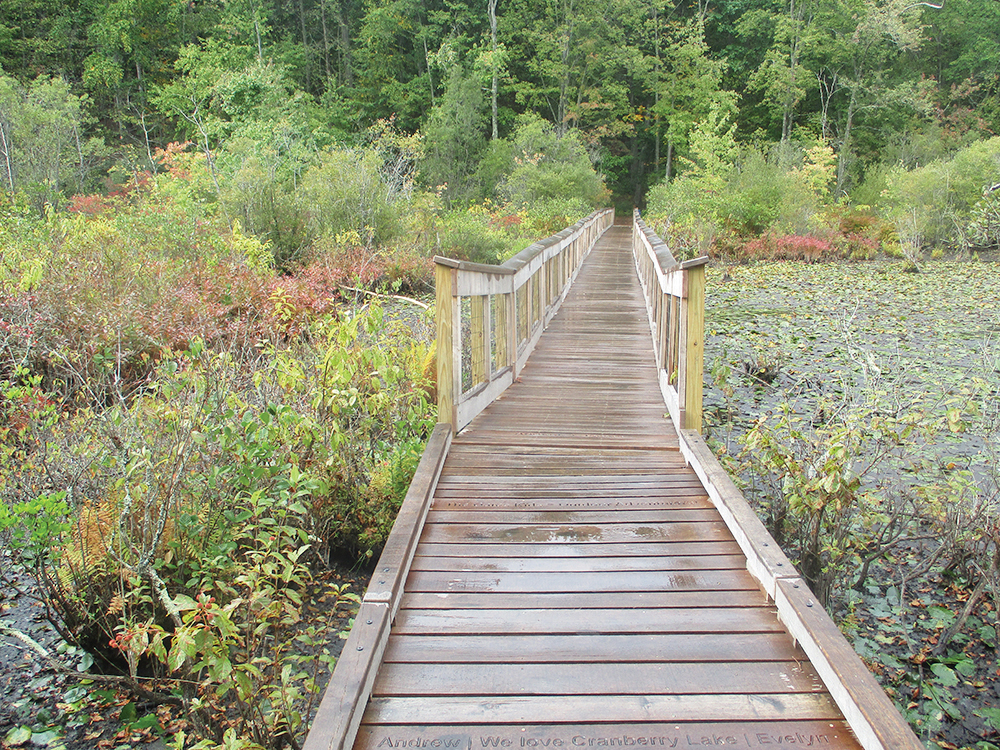
Soon, the cliffs are supplanted by a concrete wall. This wall is a remnant of a facility built about 1912 to crush stone that was quarried just to the east of the trail and used for the construction of the Kensico Reservoir. Just beyond a crumbling section of the wall, you’ll reach junction #13, where a side trail leads left to a wooden observation platform and a boardwalk over South Pond. The view from the observation platform is largely obscured by vegetation, but the boardwalk offers good views over the pond and is worth the short detour.
Return to the main trail and turn left (north), now following both blue and red blazes. After passing on the right Audio Tour Stop 8 (Crusher Foundations), you’ll reach a small cascade with a bench (junction #14). Here, you should turn right onto the History Trail, marked with purple-dot-on-white blazes, and climb rather steeply over rocks and tree roots.
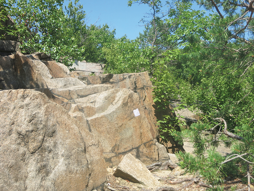
At the top of the climb, the trail bears left, crosses a wet area on puncheons, and passes to the right of an abandoned tennis court. At the next junction (#17), turn right and pass a pond on the left. Just beyond, bear right at a fork. After passing a set of historic train wheels, bear left and follow purple paint blazes up sloping rock slabs and rock steps. At the top, you’ll come to a viewpoint over the site of the former quarry below (now overgrown with trees).
Continue to follow the purple paint blazes around the rim of the quarry, soon reentering the woods. In a short distance, the trail begins to descend. After passing a concrete foundation, you’ll reach a junction marked by a bench. Turn right at this junction and follow an unmarked trail (not shown on the map) that heads north, soon beginning a rather steep descent.
At the base of the descent, turn right onto the Red Loop/History Trail (purple dot on white) and cross a boardwalk. Bear right at the next junction (#23), continuing to follow the red and purple-dot-on-white blazes. After curving to the left, the trail reaches a T-intersection (junction #34), with cliffs ahead. Here, the red and purple-dot-on white blazes turn right, but you should turn left, now following the Yellow Loop.
At the next junction (#33), bear left, continuing to follow the yellow blazes, and descend to the lake. At junction #24, turn right and follow yellow and blue blazes, with the trail (mostly on boardwalks) paralleling Cranberry Lake. After bearing left at junction #27, you’ll reach a viewpoint over the lake. Just beyond, you’ll reach junction #26. From here on, you will be retracing the route you followed at the start of the hike. Turn right onto the orange-blazed trail, follow it back up to junction #4, and turn right on the Yellow Loop to return to the Nature Center where the hike began.
This hiking article is provided by Daniel Chazin of the New York-New Jersey Trail Conference. The Trail Conference is a volunteer organization that builds and maintains over 2,000 miles of hiking trails and publishes a library of hiking maps and books. The Trail Conference’s office is at 600 Ramapo Valley Road (Route 202), Mahwah; (201) 512-9348; www.nynjtc.org. Daniel Chazin can be reached at DChazin@aol.com.