


This seven-mile moderate hike explores the northwest section of Fahnestock State Park in the East Hudson Highlands, climbing to the summit of Round Hill. Along the way, the hike passes two viewpoints, and it returns via a pleasant valley, with stone walls and other remnants of the land’s former agricultural use. Dogs are permitted on leash. The hike should take about four-and-a-half hours.
To reach the trailhead from Bergen County, take the Palisades Interstate Parkway to its end at the Bear Mountain Bridge, and cross the bridge. At the east end of the bridge, turn left and proceed north on N.Y. Route 9D for 8.0 miles to Peekskill Road at the southern end of Cold Spring (just beyond the Boscobel Restoration). Turn right and follow Peekskill Road for 0.5 mile to its terminus at N.Y. Route 301, then turn right and follow Route 301 for 2.0 miles to its intersection with U.S. Route 9. Turn left onto Route 9 and proceed north for 0.2 mile, then turn right onto Campbell Road at a brown sign for the “Hubbard Lodge.” Bear left at the fork, continue past a house on the left, and park along the right side of the road. GPS address: 2920 U.S. Route 9, Cold Spring, NY 10516. The trailhead is 50 miles from Teaneck, and it should take about one hour to get there.
If coming from Riverdale or Westchester County, take the Saw Mill River Parkway to the Taconic State Parkway. Take Exit 5 and continue on N.Y. Route 9A North. When Route 9A ends, proceed ahead on Route 9 for about 20 miles to N.Y. Route 301. Continue on Route 9 for 0.2 mile beyond Route 301, turn right onto Campbell Road at a brown sign for the “Hubbard Lodge,” and follow directions above.
To start the hike, walk back along the paved road to a junction with a gravel road on the left. Turn left onto the gravel road at a gate. A triple-white blaze on the gate marks the start of the white-blazed School Mountain Road, and a triple-blue blaze marks the start of the blue-blazed Fahnestock Trail. Continue ahead on the road, which soon crosses two streams on wooden bridges built by civil engineering cadets of the West Point Military Academy.
In about half a mile, you’ll notice two stone pillars on the left. The road formerly crossed the stream here on a steel-plate bridge, but the bridge was washed out by Hurricane Irene in August 2011. Turn right, descend stone steps, and cross the stream on two steel I-beams.
Just beyond, the blue-blazed Fahnestock Trail turns sharply right, leaving School Mountain Road. Continue along the blue-blazed trail, which parallels the stream, following an old woods road which has narrowed in places to a footpath. In 0.2 mile, the woods road leaves the stream, and about half a mile from School Mountain Road, the Fahnestock Trail turns left, leaving the woods road, and begins a rather steep climb of Round Hill on switchbacks.
At the top of the steep climb, the trail reaches a limited west-facing viewpoint amid red cedars, with Bull Hill (Mt. Taurus) in the distance. The trail continues up the cedar-studded ridge of Round Hill, climbing gradually.
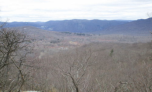
After following the ridge for about half a mile, the trail bears right, descends slightly into a shallow ravine, then climbs more steeply on a winding path. It levels off and soon reaches a panoramic southwest-facing viewpoint from a rock ledge to the right of the trail just below the summit of Round Hill.
After climbing a little more, the trail descends rather steeply to a woods road in a valley. The trail turns right onto the woods road, briefly joining the green-blazed Round Hill Bypass Trail, and follows the road as it bends left and climbs over a rise, then descends gradually.
Continue on the Fahnestock Trail as it levels off, crosses a seasonally wet area, then climbs gradually. The trail makes a short, steep climb of a rock ledge, then continues to climb steadily to the crest of another ridge, first rather steeply, then more gradually. There are no views from the wooded summit (the highest point on the hike; elevation 1,180 feet), marked by a large lichen-covered boulder to the right of the trail.
The trail now begins to descend, first very gradually, then more steeply. After crossing a stream and climbing over a low rise covered with mountain laurel, the trail continues to descend, soon reaching a junction with the yellow-blazed Perkins Trail. You’ve now gone a little more than halfway along the hike.
Turn left at this intersection, leaving the blue-blazed Fahnestock Trail, and follow the yellow-blazed Perkins Trail, a wide multi-use trail, which descends on a winding route, crossing two wooden bridges over streams. When the Perkins Trail ends at a junction with the white-blazed School Mountain Road, turn left onto School Mountain Road, which continues to descend on switchbacks. At the base of the descent, you’ll reach a T-intersection. Here, the red-blazed East Mountain Loop begins on the right, but you should turn left to continue on the white-blazed School Mountain Road.
A short distance ahead, you’ll pass an abandoned farmhouse on the left. Follow School Mountain Road as it bears right, crossing a stream on a wooden bridge, and proceed ahead as the road continues through a pleasant valley. In half a mile, you’ll reach a junction where the green-blazed Round Hill Bypass Trail begins on the left and the red-blazed East Mountain Loop ends on the right. Continue ahead for another quarter mile on the white-blazed School Mountain Road.
After crossing a wooden arch bridge over a tributary stream, you’ll reach a junction where the yellow-blazed Hubbard Loop begins on the right. Bear right and continue on the Hubbard Loop, which climbs gradually on a woods road bordered on the left by a stone wall, passing abandoned farm settlements along the way.
Just beyond the crest of the rise, the trail bears left, leaving the woods road, then rejoins the road just ahead. The road is now bordered by stone walls on both sides. Soon, you’ll pass an interesting stone structure on the right.
After curving to the left, the Hubbard Loop passes between two stone pillars and ends at School Mountain Road, opposite the steel I-beams that you used to cross the stream earlier in the hike. Turn right onto the white-blazed School Mountain Road (also the route of the blue-blazed Fahnestock Trail), retracing your steps back to the starting point of the hike.
This hiking article is provided by Daniel Chazin of the New York-New Jersey Trail Conference. He can be reached at [email protected].


