This easy-to-moderate 5.6-mile loop hike circles the Jockey Hollow section of the Morristown National Historical Park (in Morris County, New Jersey). Here, the Continental Army, under the command of George Washington, encamped for the brutally cold winter of 1779-80. Little remains of the historic encampment, but today’s park offers an attractive network of hiking trails.
This hike follows the white-blazed Grand Loop Trail—the longest of the park’s marked trails.
The hike should take about three hours (allow extra time if you plan on visiting the Wick House or the Soldier Huts). Although the route is relatively level, there are several gradual ascents and descents. Dogs are permitted on leash. Most trail junctions in this park are marked by numbered signposts, which are referred to in the hike description. A trail map is available online at www.nps.gov/morr/planyourvisit/maps.htm
To get there, take I-80 West to Exit 43 and continue on I-287 South. Take Exit 30B and, at the first traffic light, turn right onto Route 202. Proceed north for 1.8 miles, and turn left onto Tempe Wick Road at a traffic light. Continue along Tempe Wick Road for 1.4 miles to the park entrance, on the right. The visitor center parking area is just ahead. The trailhead is about 40 miles from Teaneck, and it should take about 50 minutes to get there.
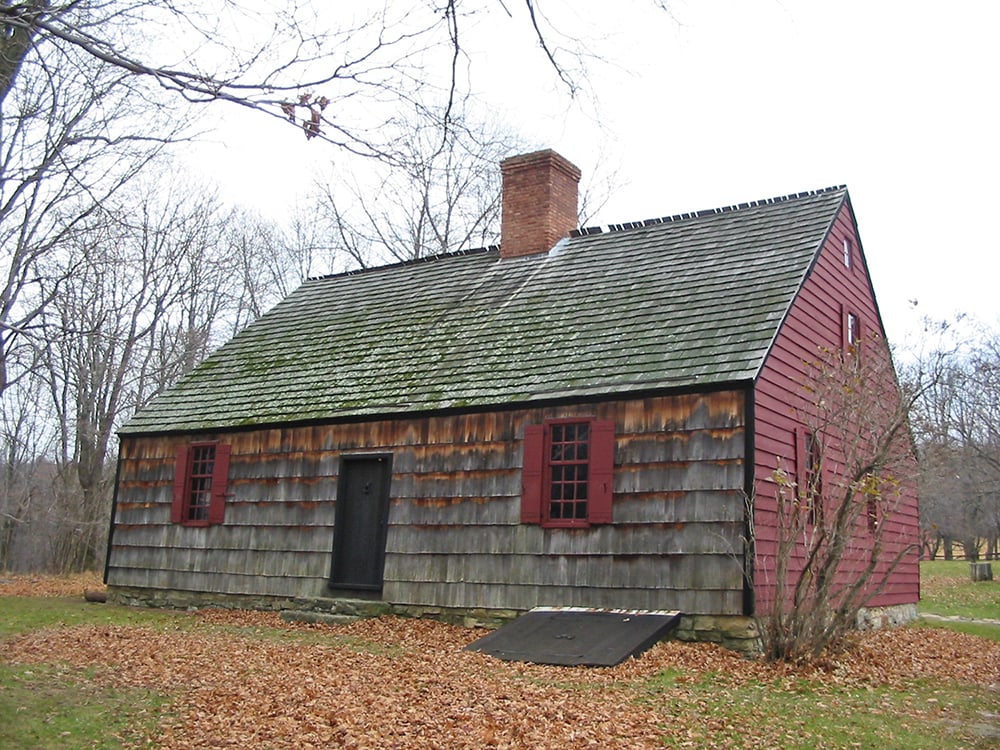
From the parking area, proceed to the visitor center. After viewing the exhibits, exit the back door, and follow a paved path past the Wick Farm. The path turns right at the Wick House (which is worth a visit), but you should continue ahead and proceed downhill along a wide grassy strip, with a split-rail fence on the right. After crossing a paved road, proceed straight ahead along another paved road. Near the bottom of the hill, before reaching Tempe Wick Road, turn right at a sign for the Grand Loop Trail.
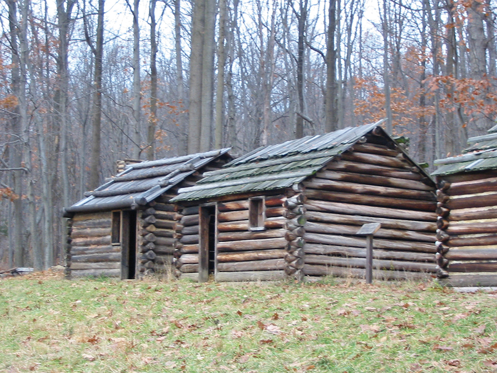
Upon reaching the Grand Loop Trail, turn right and proceed rather steeply uphill for 0.2 mile (this is the steepest climb of the entire hike). The trail levels off and descends to reach a junction, marked by Signpost #3, where the trail bears left. After a relatively level stretch, the trail climbs gradually to the top of a hill, where it begins to closely parallel the park boundary (Lewis Morris County Park is on the left). The trail descends into a valley, then climbs to reach a junction (signpost #4) where the Patriots’ Path (blue path-and-tree logo on white) joins from the right. A sign points the way to the restored Soldier Huts, a short distance downhill to the right, which are worth a visit.
Follow the Grand Loop Trail as it continues ahead, now running concurrently with the Patriots’ Path. When the Patriots’ Path leaves to the left in another 900 feet (Signpost #5), bear right and continue to follow the Grand Loop Trail as it descends, passing Signpost #6 and continuing across an open field. After crossing paved Sugarloaf Road, the trail reenters the woods at Signpost #7. It ascends gradually, levels off, then bears right and descends across the side of a hill. At the next intersection (Signpost #8), the Grand Loop Trail turns left and soon levels off. After climbing a little, it crosses paved Jockey Hollow Road, passes Signpost #9, and reenters the woods, running close to the park boundary, with homes visible to the left.
After descending gradually and bending sharply left, the Grand Loop Trail turns right at Signpost #10, joining the Blue Trail. The joint white/blue trail follows a wide dirt road and passes a small pond on the left. A bench has been placed here, making it an attractive spot for a break.
Just beyond, a Y-intersection is reached (Signpost #22). Here, the Blue Trail leaves to the right, but you should take the left fork, continuing along the white-blazed Grand Loop Trail, which descends gradually and begins to parallel a stream on the left. At a T-intersection (Signpost #21), the Grand Loop Trail turns left, now joined by the Patriots’ Path and the Blue Trail, both of which come in from the right. The joint trails cross a wide wooden bridge over a stream and reach Signpost #20. Turn sharply right here, following the Grand Loop Trail and the Patriots’ Path (the Blue Trail continues straight ahead).
The joint Grand Loop Trail/Patriots’ Path descends to cross the red-blazed Primrose Brook Trail at Signpost #30. Just beyond, the trail crosses Primrose Brook on a wide wooden bridge. After crossing a tributary stream on another wooden bridge, it recrosses the Primrose Brook Trail at Signpost #31. After a gradual ascent, the trail bears left and passes an interpretive sign with the story of the Connecticut Line. Just ahead, the Grand Loop Trail/Patriots’ Path crosses the wide, unblazed Mendham Road Trail (Signpost #55). (To the right, the Mendham Road Trail leads back to the Visitor Center in 0.3 mile and can be used to shorten the hike.)
The Grand Loop Trail/Patriots’ Path now descends to cross paved Tempe Wick Road at Signpost #56. After descending to cross a stream on a wooden bridge (Signpost #57), the trail climbs to a junction (Signpost #58). Here, the Patriots’ Path (following the route of the New Jersey Brigade Trail) bears left, but you should turn right, following the white blazes. The Grand Loop Trail heads west and then north, roughly parallel to Tempe Wick Road. At Signpost #59, a dirt road joins from the left, and the Grand Loop Trail descends to end at Tempe Wick Road. To return to the parking area where you began the hike, turn right onto the road marked with a “Do Not Enter” sign and proceed ahead past the Wick Farm to the visitor center.
This hiking article is provided by Daniel Chazin of the New York-New Jersey Trail Conference. The Trail Conference is a volunteer organization that builds and maintains over 2,000 miles of hiking trails and publishes a library of hiking maps and books. The Trail Conference’s office is at 600 Ramapo Valley Road (Route 202), Mahwah; (201) 512-9348; www.nynjtc.org. Daniel Chazin can be reached at DChazin@aol.com.


