
This delightful 3.9-mile hike follows the Indian Hill Loop Trail in the northern section of Sterling Forest State Park. It climbs to several panoramic viewpoints and crosses many stone walls, built over a century ago by the first settlers of the area, primarily to mark property boundaries. Some of these stone walls are unusually wide. This moderate hike should take about two and one-half hours. Dogs are permitted on leash.
To get to the trailhead from Bergen County, take New Jersey Route 17 north to the New York State Thruway. Bear left at the fork (following I-87 towards “Albany”) and take the first exit, Exit 15A (Sloatsburg). Turn left at the bottom of the ramp onto NewYork Route 17 north, and proceed through Sloatsburg and Tuxedo. In 8.6 miles (1.3 miles beyond the intersection with NY 17A in Southfields), turn left onto Orange Turnpike (County Route 19) and continue for 1.3 miles to the park entrance on the right (marked by a sign for “Indian Hill”). Turn right and follow the dirt road ahead for 0.2 mile, then turn right into the parking area. The trailhead is about 30 miles from Teaneck, and it should take about 40 minutes to get there.
The hike follows the Indian Hill Loop Trail in the counterclockwise direction. From the information kiosk in the parking area, the trail proceeds through a hemlock grove, bears right and climbs to the crest of a rise. After descending a little, it climbs to reach an open granite ledge, with west-facing views over the hills of Sterling Forest.
A short distance beyond, the red-blazed Furnace Loop Trail joins from the right. This junction, like most of the trail junctions on this hike, is marked by a cairn (a pile of stones). Continue ahead, now following both yellow and red blazes, as the joint trails climb to the ridgetop, traversing rock ledges along the way, and descend into a valley, crossing a wide stone wall at the base of the descent. After climbing to another ridgetop, with views to the south and east, they descend to a junction with a woods road. The trails turn right onto the road, but you may wish to detour to the left on this road (following the route of the yellow-bird-on-green-blazed Warbler Trail), which leads in 200 feet to a dam and a picturesque pond. After visiting the pond, retrace your steps to the junction and continue ahead, following the white-stripe-on-yellow and red blazes.

Soon, the red-blazed Furnace Loop Trail leaves to the right. For the remainder of the hike, you’ll be following only the white-stripe-on-yellow blazes of the Indian Hill Loop Trail. The trail now crosses a stream on rocks and climbs to a panoramic south-facing viewpoint from a rock ledge. It then ascends to the ridgetop, which it follows north.
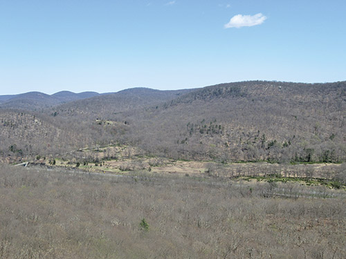
After a relatively level stretch, the trail climbs to the highest point on the ridge (1,047 feet). A short distance beyond, rock ledges to the right of the trail offer unobstructed views across the Ramapo Valley to Harriman State Park. Green Pond Mountain dominates the view, with the grassy Elk Pen in the foreground and the New York State Thruway below in the valley.
From the ridge, the trail descends gradually on switchbacks. Near the bottom, it briefly follows a stone wall, then turns right onto a woods road. At the base of the descent, it turns left onto a woods road between unusually wide stone walls. It is not known why these stone walls were built in this manner. Soon, the trail turns right, goes through a gap in a massive stone wall, and continues on a footpath, passing a huge oak tree.

After crossing a stone wall, the Indian Hill Loop Trail reaches a junction with a blue-blazed trail that begins on the right and heads north for half a mile to connect with the white-blazed Appalachian Trail. Here, the Indian Hill Loop Trail turns left and begins to parallel the stone wall. It soon crosses two more stone walls, as well as a woods road lined on both sides with wide stone walls (this is the same woods road that you followed a few minutes ago).
After passing through a wide gap in yet another stone wall, the trail turns left onto a grassy woods road. At a T-intersection, it turns right onto another woods road, which it follows for about a quarter mile to the barrier gate just beyond the parking area. Turn left and climb to the parking area, where the hike began.
This hiking article is provided by Daniel Chazin of the New York-New Jersey Trail Conference. The Trail Conference is a volunteer organization that builds and maintains over 2,000 miles of hiking trails and publishes a library of hiking maps and books. The Trail Conference’s office is at 600 Ramapo Valley Road (Route 202), Mahwah; (201) 512-9348; www.nynjtc.org. Daniel Chazin can be reached at [email protected].