This 6.5-mile moderate loop hike in the Mohonk Preserve (near New Paltz, New York) features some of the most spectacular scenery in the area. It follows the ridge of the Near Trapps and the Bayards to reach the 1,600-foot summit of Millbrook Mountain. Along the way, it passes many panoramic viewpoints from the ridge, with views extending north to the Catskills and south to the Wallkill Valley. The hike involves a total elevation gain of about 800 feet, with a few steep climbs, although most of the grades are gentle. It should take about four-and-a-half hours, and dogs are permitted on leash.
To get there, take the New York State Thruway to Exit 18 (New Paltz). At the end of the exit ramp, turn left onto Route 299 and continue west through the Village of New Paltz. When you cross the bridge over the Wallkill River at the west end of the village, continue ahead on Route 299. (Do not turn right towards the Mohonk Mountain House.) In another 5.6 miles (from the Wallkill River bridge), Route 299 ends at a T-intersection with Route 44/55. Turn right here and follow Route 44/55 as it negotiates a very sharp hairpin turn and climbs to pass under the Trapps Bridge (a steel truss overpass). Continue for 0.3 mile past Trapps Bridge and turn right into the West Trapps Trailhead Parking Area of the Mohonk Preserve. There is a $15 per person day-use fee, payable at the booth in the parking area. (You can also purchase an annual pass for $70 at www.mohonkpreserve.org.) The trailhead is about 75 miles from Teaneck and it should take about one hour and 20 minutes to get there.
From the vehicle turnaround at the eastern end of the parking area, follow the yellow-blazed West Trapps Connector Trail, a gravel road which leads east, parallel to Route 44/55. In 0.2 mile, you’ll reach the Trapps Bridge. Climb the gravel road that leads up to the bridge, turn sharply right, cross the bridge, then turn right again. About 150 feet beyond the bridge, a sign and a triple-blue blaze mark the start of the Millbrook Ridge Trail. Turn left and follow this trail—marked with plastic markers on trees and paint blazes on rocks—which steeply climbs over rock slabs dotted with pitch pines.
(Credit: Matthew Fecica)
At the top of the steep climb, you’ll reach the crest of the ridge of the Near Trapps. Here, there is a panoramic viewpoint, known as the Hawk Watch. To the left, you can see Dickie Barre, with the Catskill Mountains in the distance beyond. To the right, there is a sweeping view over the Wallkill Valley, with New Paltz visible in the distance.
The trail continues to climb through a wooded area along the ridge, with scrub oak and pitch pine and an understory of blueberry bushes. Soon, you’ll reach another viewpoint on the left, with the Sky Top tower of the Mohonk Mountain House visible to the north, and the intersection of Routes 299 and 44/55 directly below. The trail now levels off. After a brief climb up a rock outcrop, the trail begins to descend.
About a mile from the start, you’ll reach a junction with the red-blazed Bayard’s Path, which leaves to the right. Continue ahead on the blue-blazed Millbrook Ridge Trail, which bears left and climbs to the top of the next ridge, known as the Bayards. The trail follows along the ridge, reaching a broad viewpoint over the Wallkill Valley. A long, relatively level section follows, with the trail cutting through groves of mountain laurel and blueberry bushes. At the end of the level section, the trail passes on the left of a rounded outcrop with a view ahead (through the trees) of the dramatic cliff of Millbrook Mountain—the destination of the hike.
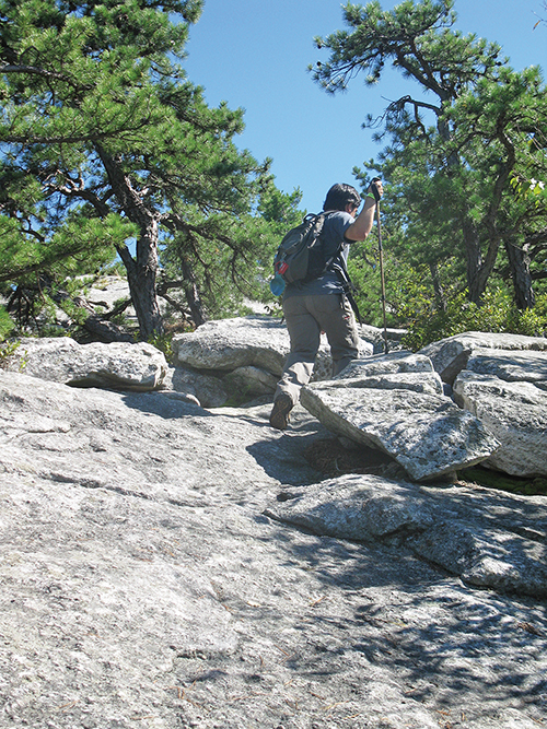
After descending through mountain laurel and hemlock, the Millbrook Ridge Trail arrives at a junction with the red-blazed Millbrook Cross Trail. You’ve now gone about two miles from the start. Continue ahead on the blue-blazed trail, which bends left and climbs to regain the crest of the ridge. Soon, it crosses a rock outcrop with several small glacial erratics. It continues on a relatively level footpath through laurel and hemlocks and emerges onto an open area, with many glacial erratics.

After traversing a rocky path through hemlocks and pines, the trail arrives at the base of a cliff. It climbs rather steeply over rocks to the right of the cliff and continues on a footpath below the crest of the ridge. Soon, the trail bears left, climbs on a rocky footpath through a boulder field, and proceeds through an open area, with blueberries and pitch pines, to reach the crest of the ridge. This is the start of the most interesting and dramatic part of the hike.
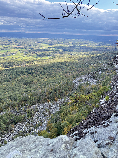
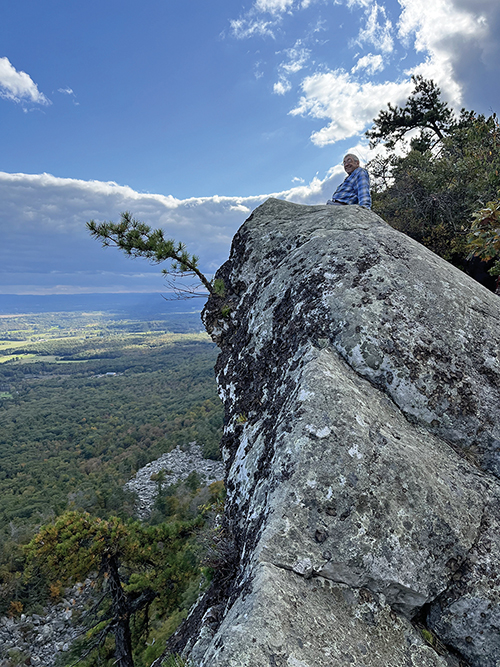
The trail bears right and continues to climb along exposed rock outcrops, with views to the south and east over the Wallkill Valley as far as the Hudson Highlands. Sky Top may be seen to the northeast, and the Catskills are in the distance to the north. After climbing some more, the trail follows a narrow path to the right of a sloping rock slab. Next, the trail climbs steeply to the very edge of the cliff, with a sheer 300-foot drop. Using extreme caution, you can peer over the sharp cliff edge and see the vast boulder field below—probably the moraine of a small glacier that remained after the main ice sheet had melted away.
The trail continues to climb along the cliff edge, passing some more viewpoints, then heads slightly inland. Finally—a little over three miles from the start—you’ll arrive at a junction with the red-blazed Millbrook Mountain Trail. This is your return route, but first, continue ahead on the blue-blazed trail for 100 feet to a sign for the Millbrook Mountain Path. Here, you should turn left and climb the rock slab to the edge of the cliff—the summit of Millbrook Mountain, which offers an even broader view than those you’ve seen until now. After taking in the view, return to the first trail junction and turn left onto the red-blazed Millbrook Mountain Trail.
In 0.2 mile, turn right onto the blue-blazed Coxing Trail, which descends steadily over rock slabs dotted with pitch pines, then bears left and continues to descend through blueberry bushes, mountain laurel, hemlock and white pine. After leveling off and crossing a stream and a wet area on puncheons, the Coxing Trail reaches a junction with the Millbrook Cross Path, which begins on the right. Continue ahead on the Coxing Trail, which widens to a woods road. This section of the trail is often quite wet, and you may have to detour off the woods road to find a drier route.
About two miles from Millbrook Mountain, the Coxing Trail ends at a junction with the dirt Trapps Road, a carriage road built by the proprietors of the Mohonk and Minnewaska Mountain Houses. Turn right and follow this level road for about a mile to the Trapps Bridge. Cross the bridge, turn very sharply left, and follow the connector trail back to the parking area where you began the hike.
This hiking article is provided by Daniel Chazin of the New York-New Jersey Trail Conference. The Trail Conference is a volunteer organization that builds and maintains over 2,000 miles of hiking trails and publishes a library of hiking maps and books. The Trail Conference’s office is at 600 Ramapo Valley Road (Route 202), Mahwah; (201) 512-9348; www.nynjtc.org. Daniel Chazin can be reached at [email protected].


