


This easy lollipop-loop hike in the New Jersey section of the Palisades Interstate Park parallels the shore of the Hudson River and affords panoramic views over the river. The hike is about 3.2 miles long and should take about two hours. Dogs are permitted on leash.
To get to the trailhead, take the Palisades Interstate Parkway to Exit 2 (Alpine) and continue ahead on the Alpine Approach Road, following signs to the Alpine Boat Basin. When you reach a traffic circle near the bottom of the hill, go three-quarters of the way around the circle, then bear right and continue downhill to the boat basin. Parking fees are charged from April 1 to October 31.
From the north end of the parking area, head north, passing the boat basin on the right and the Kearney House on the left. The house, which dates back to the 1700s and contains historical artifacts and exhibits on the history of the park, is open most weekends and holiday afternoons from May to October.
Beyond the Kearney House, cross a wooden bridge and bear left. You’ll pass a stone monument with a plaque commemorating the landing of the British troops here in 1776 and proceed uphill on the Old Closter Dock Road, paved with cobblestones. This road, which dates back to 1761, was used for many years to access the Closter Landing, where boats took freight and passengers across the river to New York. (Interestingly, the information on the plaque is incorrect in two respects: the British troops crossed the river on November 20, 1776—not November 18—and they actually landed at Huyler’s Landing, a mile and a half to the south! These errors are pointed out in an adjacent sign.)
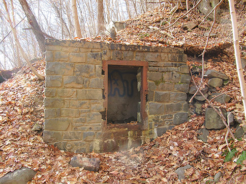
At the top of the climb, continue ahead on the white-blazed Shore Trail, as the orange-blazed Closter Dock Trail leaves to the left. The trail now levels off and continues along a pleasant, shaded woods road. Although the trail closely parallels the river, there is dense vegetation between the trail and the river, and (when there are leaves on the trees) only occasionally do glimpses of the river appear. Soon, you’ll notice stone steps climbing the hillside on the left. These steps lead to a bunker once used by the park to store dynamite. Just beyond, you’ll cross a stone bridge, with a waterfall on the left.
A short distance beyond, by a large fallen tree, a side trail heads downhill on stone steps to a rocky beach—the site of Cape Flyaway, a small fishermen’s hamlet in the 19th and early 20th centuries. In another 500 feet, a second side trail leads down to the river.
In about three-quarters of a mile, you’ll reach a fork. A sign painted on a rock indicates that the Shore Trail takes the right fork, but you should bear left and follow the Upper Trail, which continues along the woods road, running about 100 feet above the river. Soon, you’ll notice a wide path leading down to the river on your right, with picnic tables above on the left. This is the Excelsior Flats picnic area; you may wish to stop here for lunch.
Continue ahead on the Upper Trail. About three-quarters of a mile from the first junction with the Shore Trail, the Upper Trail descends to the river level, where it ends. [Note: The last part of the Upper Trail, just before reaching the Shore Trail, was eroded by Tropical Storm Ida, and care should be exercised when traversing this trail section.] Turn sharply right and head south on the Shore Trail, which runs directly along the river, with panoramic views up and down the river. Yonkers is visible across the river, and the George Washington Bridge may be seen in the distance to the south. The only sounds you’ll hear are the waves, the boats on the river, and the trains passing on the opposite shore.
In a quarter mile, you’ll pass Twombly’s Landing, a stone jetty that juts into the river. South of the jetty, the Shore Trail begins to follow a narrower path, and sections of the trail are “paved” with rocks. You should watch out for the three-leafed poison ivy, which grows in proliferation along the shore.
After about three-quarters of a mile along the Shore Trail, you’ll notice stone steps going uphill on the right and leading down to a stone jetty on the left. This is the abandoned Excelsior Dock, from which ferry service once was provided in summer months to Yonkers. If the tide is low, you might want to walk out to the rocks at the end of the dock, from which you can see Bombay Hook—a prominent landmark along the Palisades to the north.
The Shore Trail now widens to a woods road and begins to climb. Soon, you’ll reach the junction with the Upper Trail. Continue straight ahead, heading south, and retrace your steps along the Shore Trail back to the Alpine Boat Basin, where the hike began.
This hiking article is provided by Daniel Chazin of the New York-New Jersey Trail Conference. The Trail Conference is a volunteer organization that builds and maintains over 2,000 miles of hiking trails and publishes a library of hiking maps and books. The Trail Conference’s office is at 600 Ramapo Valley Road (Route 202), Mahwah; (201) 512-9348; www.nynjtc.org. Daniel Chazin can be reached at [email protected].