


Campgaw Mountain County Reservation in Mahwah is best known in the winter for skiing, but it is also an ideal place to hike. This 1.7-mile easy-to-moderate hike follows the Rocky Ridge Trail, which provides the most direct route to the summit of Campgaw Mountain. From the top of the ski slope, you get a sweeping view of Bergen County and the hills of Harriman State Park. A free trail map is available online at www.nynjtc.org/map/campgaw-mountain-brochure-map.
To reach the park, take N.J. Route 208 North to the Summit Avenue exit in Franklin Lakes. Turn left at the end of the ramp, following the sign for Franklin Lakes. At the next traffic light, turn left onto Franklin Avenue, and at the following traffic light, turn right onto Pulis Avenue. Follow Pulis Avenue for 1.5 miles and turn left onto Campgaw Road. In 1.6 miles, turn left onto the entrance road leading into Campgaw Mountain Reservation. At a fork in the road after 0.4 mile, bear left and continue for another 0.2 mile, then turn left and park at the southern end of the main parking area, near two portable restrooms.
From the southern entrance to the parking area, proceed west, crossing the park entrance road. You’ll notice three blue blazes on a pole to the right of a chained-off gravel road. These blazes mark the start of the blue-blazed Rocky Ridge Trail, which you’ll be following for most of the hike.
Just ahead, the Rocky Ridge Trail splits into two branches. To follow the trail in a clockwise direction, turn left, leaving the gravel road, and follow a blue-blazed footpath through a wooded area. The trail goes to the right of a park building and crosses a grassy area, passing under high-voltage power lines. At a yellow gate, follow the blue blazes as the Rocky Ridge Trail descends to cross the red-on-white-blazed Old Cedar Trail. After passing a swampy area on the left, the Rocky Ridge Trail ascends along the wide route of an abandoned bobsled run. Halfway up the hill, the green-blazed Beeches Trail crosses. Just beyond, you’ll notice (on the right) old machinery formerly used to make snow for the bobsled run.
In about half a mile, as it approaches the ridge, the Rocky Ridge Trail bears right and climbs on a broad switchback. At the crest of the ridge, it briefly joins the red-on-white-blazed Old Cedar Trail. When the two trails diverge, proceed straight ahead on the blue-blazed Rocky Ridge Trail, which follows a rocky footpath along the ridgeline, soon beginning a steady, gentle descent. The trail passes several tees and yellow-rimmed metal baskets for disc golf, one of the activities offered in the park.
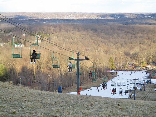
After passing through an area with many cedar trees, you’ll come to a T-intersection where the Rocky Ridge Trail turns right and descends. This will be your return route, but for now, turn left onto a blue/red-on-white-blazed connector trail. In 250 feet, the blue/red trail turns sharply left. Turn right here, leaving the blue/red trail, and cross the open area to reach an expansive east-facing viewpoint at the top of the ski slope. To the left are the hills of Harriman State Park, and in the center is northern Bergen County, with Mahwah in the foreground. The Palisades can be seen on the horizon. This is a good place to take a break.
When you’re ready to continue, return to the trail on the southwest side of the clearing. Turn left and continue along the red/blue trail, retracing your steps for 250 feet, then proceed straight ahead on the blue-blazed Rocky Ridge Trail, which descends gradually—first on a woods road, then on a footpath. After moving away from the ski slopes, the trail goes by disc golf tees and yellow-rimmed baskets, then passes a snow-tubing area on the left. A short distance beyond, it passes a wooden footbridge on the right, goes by another disc golf tee, and briefly joins a wide woods road. Soon, it bears left and follows a footpath parallel to the road. It passes the northern terminus of the green-blazed Beeches Trail, then descends through the woods on a footpath, with Fyke Pond visible ahead through the trees (during leaf-off season).
At the base of the descent, the blue-blazed Rocky Ridge Trail turns right onto a gravel road, joining the orange-blazed Hemlock Trail. The red-on-white-blazed Old Cedar Trail soon crosses, and the Hemlock Trail leaves to the left, but you should continue ahead on the Rocky Ridge Trail to its terminus at the park entrance road. The parking area where the hike began is just ahead.
This hiking article is provided by Daniel Chazin of the New York-New Jersey Trail Conference. The Trail Conference is a volunteer organization that builds and maintains over 2,000 miles of hiking trails and publishes a library of hiking maps and books. The Trail Conference’s office is at 600 Ramapo Valley Road (Route 202), Mahwah; (201) 512-9348; www.nynjtc.org. Daniel Chazin can be reached at [email protected].
By Daniel Chazin


