
This moderate-to-strenuous 4.5-mile hike in Harriman State Park goes by Green Pond, one of the few pristine lakes in the park, and reaches the Boston Mine, a 19th-century iron mine carved into the hillside. The hike, which should take about two and a half hours, is not exceptionally difficult (it involves a gain of elevation of about 500 feet), but it is rated “moderate-to-strenuous” because there are several steep climbs and descents, and a few sections traverse very rocky terrain. Dogs are permitted on leash.
To get to the trailhead from Bergen County, take N.J. Route 17 north to the New York State Thruway. Bear left at the fork (following I-87 towards Albany) and take the first exit, Exit 15A (Sloatsburg). Turn left at the bottom of the ramp onto N.Y. Route 17 north, and continue for 2.5 miles through the Village of Sloatsburg. Just past the village, turn right at the traffic light, following the sign for Seven Lakes Drive/Harriman State Park. Continue on Seven Lakes Drive for 10.3 miles to the Tiorati Circle.
Take the third exit from the traffic circle, which leads to Arden Valley Road. Go around the barricade (it warns, “no thru traffic,” but it is permissible to use Arden Valley Road to access the Elk Pen parking area) and continue on Arden Valley Road for 4.8 miles. Turn left and park in the Elk Pen parking area. NOTE: The bridge that carries Arden Valley Road over the New York State Thruway is closed to vehicular traffic, so the Elk Pen parking area cannot be accessed directly from Route 17. The trailhead is about 40 miles from Teaneck, and it should take about 55 minutes to get there.
From the parking area, proceed east on a grassy woods road across the meadow. You are following the white-blazed Appalachian Trail, with some white blazes on posts. At the end of the meadow, the trail curves to the right. In another 100 feet, the Appalachian Trail leaves to the left, but you should continue ahead, now following the inverted-red-triangle-on-white blazes of the Arden-Surebridge (A-SB) Trail.

You are heading south along the Arden Road, built by Edward Harriman in the 1890s. In places, the old road has narrowed to a footpath. You will notice remnants of an old wire fence on the right. This fence was built to enclose an area once inhabited by elk brought from Yellowstone National Park in 1919. The elk did not thrive, and the small remnant of the herd was relocated in 1942. The area formerly enclosed by the fence, though, is still known as the Elk Pen.
In a third of a mile, the A-SB Trail turns left, leaving the road, but you should continue ahead along the road, now following the Stahahe Brook Trail, marked with red-horizontal-stripe-on-white blazes. In another third of a mile, you’ll reach Stahahe Brook, with attractive cascades on the left. The road formerly crossed the brook on a stone-arch bridge, but the bridge was washed away during Hurricane Irene in 2011.
Follow the Stahahe Brook Trail as it turns left and begins to climb on a footpath parallel to the brook, visible below to the right. In about 0.4 mile, after a brief descent, the Stahahe Brook Trail ends at a junction with the white-blazed Nurian Trail.

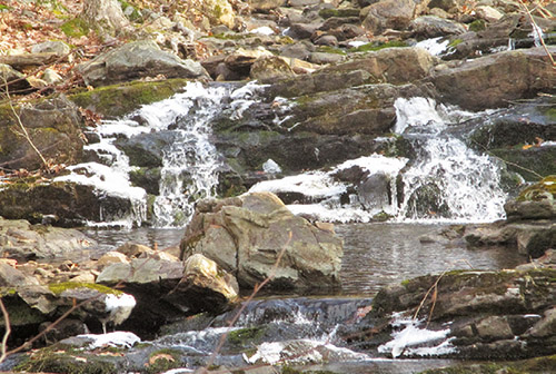
Turn left onto the Nurian Trail, which climbs on switchbacks. From the crest of the rise, the trail descends to cross the outlet stream of Island Pond, with a cascading waterfall on the left. It then turns left and begins to parallel the stream, passing more cascades and waterfalls. At the top of the ravine, it goes through the Valley of Boulders—a narrow passage between large rocks.
After climbing some more, the Nurian Trail bears left and runs along a long, sloping rock, with limited west-facing views. A short distance beyond the end of the rock, you’ll reach a junction with the yellow-blazed Dunning Trail. Turn right, leaving the Nurian Trail, and follow the yellow blazes.
The Dunning Trail soon reaches a rock ledge overlooking Green Pond. This pristine pond—one of the very few in the park that was not enlarged by the construction of dams—is surrounded by reeds. You’ll want to take a break here to enjoy the wild beauty of this special spot.
The trail continues along the north shore of Green Pond, following a rugged, rocky route. At one point, the trail passes beneath an overhanging rock. The trail bears right at a fork and continues along the east shore of the pond. After moving away from the pond, the Dunning Trail crosses the white-blazed Nurian Trail, then turns left onto Island Pond Road, a woods road. Soon, the yellow-blazed trail turns right, leaving the road, and—in about 150 feet—reaches the entrance to the Boston Mine. This mine, which was last worked in 1880, is cut into the hillside, with a water-filled pit at the northern end. The mine entrance is usually quite wet, and caution should be exercised. (Do not approach the water-filled pit.)

After taking a look at this interesting mine, go back to Island Pond Road and turn right. There are no blazes to guide you along this stretch of the road, but the route is clear and unmistakable. The road gradually descends through hemlocks and mountain laurel. After about a third of a mile, the A-SB Trail (inverted red triangle on white blazes) joins from the right. You’ll be following this trail for nearly the rest of the hike.
Just beyond, you’ll reach a fork, where you should bear left, continuing to follow the red-triangle-on-white blazes. A short distance beyond, the red-triangle-on-white blazes bear left again, leaving Island Pond Road, and descend to cross the outlet stream of Island Pond. The trail continues around the southern end of Green Pond Mountain and comes out in an area where young hemlocks and pines are beginning to revegetate an area damaged by a forest fire. Just before the trail begins a steep descent, an unmarked side trail on the right leads to a limited west-facing viewpoint from open rocks.
The A-SB Trail now turns right and begins to run along a ledge, with a fairly steep drop to the left. Soon, it turns sharply left and begins a rather steep descent on switchbacks, passing a huge overhanging rock on the left. At the base of the steep descent, it bears left and crosses a stream. It then turns right, climbs a little and levels off, passing an interesting rock formation on the right. Soon, it again begins to descend, but on a more moderate grade.
After crossing another stream, you’ll reach Arden Road. Turn right and follow the road, now retracing your steps. Where the A-SB Trail ends, turn left and follow the white-blazed Appalachian Trail across the meadow to return to the Elk Pen parking area, where the hike began.

This hiking article is provided by Daniel Chazin of the New York-New Jersey Trail Conference. Daniel Chazin can be reached at DChazin@aol.com.