


This easy-to-moderate loop hike in the Wildcat Ridge Wildlife Management Area in the Farny Highlands of Morris County leads to a panoramic east-facing viewpoint known as the Hawk Watch and passes an interesting beaver pond. The hike is 2.4 miles long and should take about two hours. Dogs are permitted on leash.
To get to the trailhead, take I-80 to Exit 37 (Hibernia/Rockaway) and bear left at the end of the ramp. Continue north on Green Pond Road (County Route 513) for 6.4 miles and turn right onto Upper Hibernia Road. (If coming from the north, you can take N.J. Route 23 to Green Pond Road, head south for 5.3 miles, and turn left onto Upper Hibernia Road.) In 2.5 miles, the paving ends. Continue ahead on the gravel road for another 0.2 mile to a large gravel parking area, with a kiosk for the Wildcat Mountain WMA on the left. The trailhead is about 40 miles from Teaneck, and it should take about 45 minutes to get there. The trailhead GPS coordinates are 40.954420, -74.479242.
From the kiosk, continue ahead (southwest) for 100 feet on the gravel road, then turn left onto another gravel road and pass between two metal gateposts. You’re now following the route of the orange-blazed Hibernia Brook Trail. In another 100 feet (before reaching a locked gate), follow the orange-blazed trail as it turns right, leaving the gravel road, and enters the woods on a footpath. The trail proceeds through a deciduous forest with an understory of blueberry bushes. After a level stretch, the trail climbs to reach an exposed bedrock slab with glacial striations, and then descends. On the way down, it passes a rail with a pointed tip embedded in the ground to the left of the trail. This unusual feature once served as a boundary marker.
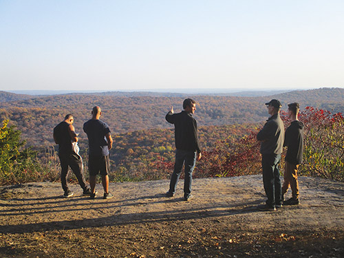
After passing through a valley, the trail climbs rather steeply, levels off and crosses a woods road. It continues on a level footpath, then climbs a little to reach a T-intersection with a woods road. Follow the orange-blazed trail as it turns right onto the road. In 125 feet, you’ll reach a junction with the white-blazed Four Birds Trail. You’ll be heading north on this trail, but for now, continue ahead on the orange-blazed trail for 500 feet to the Hawk Watch-—an open rock ledge that provides a panoramic view over the Rockaway Valley below. During the fall and spring migratory seasons, volunteers record the numbers of migratory birds observed here. On a clear day, portions of the New York City skyline can be seen on the horizon to the left.
Even if you’re not a hawk-watcher, you’ll want to spend some time at this beautiful location. When you’re ready to continue, retrace your steps to the white-blazed Four Birds Trail and turn right, now heading north. The trail immediately crosses a gravel road (which, to the right, leads to a television transmission tower) and begins a long, steady descent. In half a mile, at the base of the descent, the trail traverses a rocky area, crosses a stream on a wooden footbridge, and begins a steady climb.
In another quarter mile, you’ll reach a junction with the red-blazed Beaver Pond Trail, which begins on the left. (The triple-blaze marking the start of the trail is about 50 feet from the junction.) Turn left and follow the Beaver Pond Trail, which climbs gradually. At the crest of the rise, a short side trail on the left leads to an interesting split rock, with a south-facing view through the trees during leaf-off season. The tower on the ridge ahead is the television transmission tower just north of the Hawk Watch.
The trail now descends slightly to reach the large Beaver Pond (which may be covered with water lilies in the summer). A beaver lodge may be seen directly ahead, with two abandoned telephone poles incongruously sticking out of the water. Here, the trail turns left and follows along the southern shore of the pond. Beyond the pond, the trail widens to a gravel road. After passing an abandoned stone building—a crusher from the Willis Mine that was once active here—the Beaver Pond Trail ends at a locked gate.
Continue ahead along the left side of the large, open gravel area. When you reach the gravel Upper Hibernia Road, you’ll notice a sign on the left marking the continuation of the yellow-blazed Wildcat Ridge Trail. Turn left and follow this trail into the woods. Soon, the trail begins to run along a mining berm that parallels a ditch. (The ditch once carried a pipe that supplied compressed air to the mines.)
After moving away from the berm, the yellow-blazed trail ends at a gravel road. Turn right onto the gravel road, then right again at the next intersection to return to the parking area where the hike began.
This hiking article is provided by Daniel Chazin of the New York-New Jersey Trail Conference. The Trail Conference is a volunteer organization that builds and maintains over 2,000 miles of hiking trails and publishes a library of hiking maps and books. The Trail Conference’s office is at 600 Ramapo Valley Road (Route 202), Mahwah; (201) 512-9348; www.nynjtc.org. Daniel Chazin can be reached at [email protected].


