


This 6.2-mile moderate-to-strenuous hike in Harriman State Park climbs to a high point on West Mountain, passing several panoramic viewpoints along the way. The hike, which involves a climb of over 1,000 vertical feet, should take about five hours. Dogs are allowed on leash. An added bonus of taking the hike in the month of July is the presence of delicious blueberries along the trails!
To get there, take the Palisades Interstate Parkway north to Exit 17 (Anthony Wayne Recreation Area). Continue past the first large parking area and bear left at the fork, following the sign for the “Far South Parking Area.” Continue through the Far South Parking Area and park at the southern end.
From the kiosk at the southern end of the parking area, proceed south on the Horn Hill Loop Mountain Bike Trail, with blue-on-white diamond blazes. The trail passes through a pine forest and crosses several bridges. In about half a mile, you’ll cross the white-blazed Appalachian Trail, and soon afterwards, you’ll reach a junction with the red-on-white-blazed Ramapo-Dunderberg (R-D) Trail. Turn left onto the R-D Trail, which begins to climb West Mountain.
After ascending stone steps, the R-D Trail crosses the wide Beechy Bottom East Road, also marked with the blue-on-white blazes of the Horn Hill Bike Trail. It continues to climb steadily through dense mountain laurel thickets until it bears left and crosses a gully. The trail now turns left, passes an old mine opening and continues around the side of the mountain. Soon, it turns sharply left, climbs steeply, then follows a level path alongside a cliff, with views through the trees to the left.
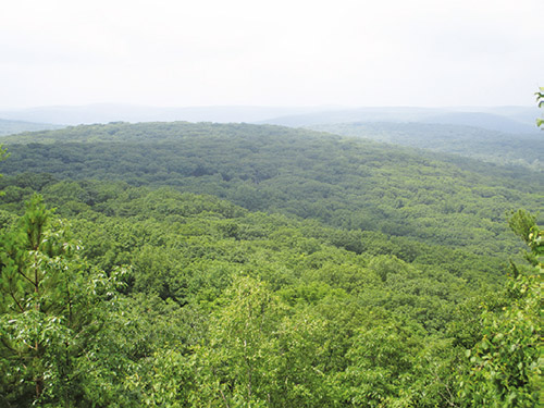
After passing a west-facing viewpoint through the trees, the trail bears right and continues to climb, soon reaching a panoramic viewpoint (known as the Cats Elbow) at a junction with the yellow-blazed Suffern-Bear Mountain (S-BM) Trail. You can see the Hudson River on the left and the hills of Harriman State Park ahead, with the New York City skyline visible in the distance on a clear day. You’ll want to take a break here to rest from the climb and enjoy the views.
When you’re ready to continue, proceed ahead on the joint R-D/S-BM Trail. In 300 feet, after climbing a ledge, the two trails diverge. Turn left and follow the yellow blazes of the S-BM Trail, which descends slightly and proceeds through an area scarred by fire a number of years ago and now starting to regenerate.
After descending to a valley, crossing a stream on rocks and then climbing again, the S-BM Trail reaches a T-intersection where the blue-blazed Timp-Torne Trail joins from the left. Turn right, following the blue/yellow-blazed trail, which runs along ledges, with views to the south.
In another 0.3 mile, after passing a viewpoint from a rock ledge on the right, you’ll come to a junction. Here, the yellow-blazed S-BM Trail continues ahead, but you should bear right, following the blue-blazed Timp-Torne Trail. In 500 feet, you’ll arrive at the West Mountain Shelter, built in 1928, which offers panoramic views of the Hudson River to the southeast. This is a good place to stop for a break.
After you’ve rested for a while, retrace your steps back to the junction of the blue and yellow trails. Turn right at the junction, following the yellow-blazed S-BM Trail, which descends a little, then climbs to reach an open area, with views of Bear Mountain to the north through the trees. The trail now descends, first steeply, then more gradually through mountain laurel thickets. After reaching a valley at the base of the descent, it once again climbs steeply. In a level area at the top of the steep climb, there is a limited viewpoint to the southeast from a rock ledge to the right of the trail.
After climbing gradually to reach the highest point on the ridge, the S-BM Trail begins a steady descent of about 700 vertical feet. It soon reaches a very steep section, where extreme care should be taken if the trail is wet, icy or snow-covered. The grade then moderates somewhat. About halfway down, the trail crosses a stream and joins an old woods road, with more gentle grades. The road is eroded in places, and some stretches of the trail have been routed away from the road.
At the base of the descent, follow the yellow-blazed S-BM Trail as it turns left onto a level road, the route of the Doodletown Bridle Path. When the yellow blazes go off to the right, continue ahead on the wide bridle path, now following the Fawn Trail, blazed with red-“F”-on-white blazes, which begins here. The trail soon begins a gradual climb. In about half a mile, at a T-intersection, the Fawn Trail bears left, leaving the bridle path. Continue to follow the red-“F”-on-white blazes of the Fawn Trail.
The Fawn Trail climbs over a rise and descends to cross the white-blazed Appalachian Trail. After a short climb, the Fawn Trail crosses the blue-blazed Timp-Torne Trail and descends to end at a junction with the white-blazed Anthony Wayne Trail at Beechy Bottom East Road. Turn left and follow Beechy Bottom East Road as it heads south. Almost immediately, you’ll reach an intersection where the Horn Hill Loop Mountain Bike Trail joins from the right. Bear left and continue ahead on the bike trail, following the blue-on-white blazes along the nearly level Beechy Bottom East Road. (Do not follow the white blazes of the Anthony Wayne Trail, which turns right and descends to the northern parking area at the Anthony Wayne Recreation Area.)
In about a third of a mile, you’ll come to a Y-intersection, where you should bear right. In 100 feet, you’ll reach a second Y-intersection. Here, the bike trail bears left, but you should take the right fork, which descends towards the Anthony Wayne Recreation Area. When you reach a T-intersection near the base of the descent, turn left onto a grassy road which leads to a picnic area. Continue through the picnic area, then bear right and cross a stone-faced bridge over a stream, which leads to the northern end of the Far South Parking Area. Turn left and walk to the southern end of the parking area, where the hike began.
This hiking article is provided by Daniel Chazin of the New York-New Jersey Trail Conference. The Trail Conference is a volunteer organization that builds and maintains over 2,000 miles of hiking trails and publishes a library of hiking maps and books. The Trail Conference’s office is at 600 Ramapo Valley Road (Route 202), Mahwah; (201) 512-9348; www.nynjtc.org. Daniel Chazin can be reached at [email protected].


