


This 3.8-mile moderate hike on the Blue Trail in the 4,315-acre Ward Pound Ridge Reservation—the largest park in Westchester County—should take about two and a half hours. It is on woods roads for most of the way, but it also includes a 0.7-mile section where it climbs 350 vertical feet on rocky footpaths to reach the highest point in the reservation. Dogs are permitted on leash, and a map is available online at https://parks.westchestergov.com//wp-content/uploads/images/stories/pdfs/2020wprmap.pdf.
To reach the trailhead from Bergen County, cross the Tappan Zee Bridge and continue onto the Saw Mill River Parkway North for about 18 miles to its end at I-684. Take Exit 6 (Route 35, Cross River), turn right at the end of the ramp, and follow Route 35 for 3.7 miles to Route 121. Turn right onto Route 121, cross a bridge over the Cross River, then immediately turn left to enter the reservation. Continue for 0.7 mile to the tollbooth (a parking fee is charged on weekends, daily in the summer). Proceed for 1.3 miles beyond the tollbooth and turn left into the Kimberly Bridge parking area.
If coming from Riverdale, take the Saw Mill River Parkway North to its end at I-684 and follow the directions above.
From the parking area, return to the main park road and turn right, crossing a bridge over the Cross River. About 100 feet beyond the bridge, turn left into a grassy clearing with a picnic table and a metal grill. The trailhead for the Blue Trail is at the southeast corner of the clearing, near the grill. The branch of the trail that goes straight ahead (uphill) will be your return route, but to follow the loop in the clockwise direction, you should bear left onto a level, grassy woods road.
The first half of the hike is along this road, built by the Civilian Conservation Corps (CCC) in the 1930s. It is mostly level, with some gentle ups and downs, and it parallels a rocky escarpment on the right for much of the way.
You’ll soon cross a stone drain—one of many along the road, built by the CCC to prevent erosion. On the left, there is an interesting rock outcrop, with the Cross River just beyond. After passing through an area with a thick understory of ferns, the road heads gently uphill through mountain laurel thickets, then descends slightly.
About half a mile from the start, the road bears right and begins a steady but gradual climb. As it reaches the crest of the rise, massive rock outcrops are visible through the trees on the steep hillside to the right. The road now begins a gentle descent, passing an overhanging rock just to the right of the trail in a quarter mile.
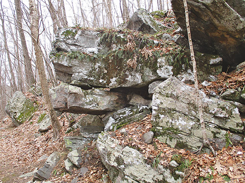
A short distance beyond, the road levels off, with a wetland on the left and a large boulder field on the right. The road now begins to run close to the park boundary, and several private homes are visible through the trees on the left. After passing a small pond on the left, the boulder-littered hillside on the right gradually steepens.
About two miles from the start, with Gilmore Pond visible through the trees on the left, the Blue Trail turns right, leaving the road, and proceeds uphill on a footpath. In a short distance, it reaches Junction 17, where a white-blazed trail goes off to the left. You should bear right to continue on the Blue Trail, which levels off.
After curving around a rock outcrop and crossing a wet area on a boardwalk, the trail climbs steeply on a rocky footpath. At the top of the climb, it reaches an area with huge rock outcrops on all sides and levels off. Soon, the trail resumes its climb. It passes through mountain laurel groves, crosses another wet area, and traverses an area with hemlocks.
The trail continues through a relatively level area, with huge rock outcrops on the left. After steeply climbing a rocky slope (you may need to use both your hands and your feet to negotiate this climb), the trail levels off and proceeds through scrub oak and blueberry bushes to reach Junction 16, where a white-blazed trail begins on the left.
Just beyond, you’ll come to a clearing at the summit (elevation 860 feet), the site of a former fire tower. All that remains is a nonfunctional water pump and the ruins of the observer’s stone cabin. Although there is no view from this spot, a bench has been placed on the west side of the clearing, and this is a good place to take a break.
When you’re ready to continue, proceed ahead on the Blue Trail, which once again follows a woods road (which formerly provided vehicular access to the fire tower). The road descends gradually through thickets of laurel. After going down more steeply on a gravel-covered section of the road, you’ll reach a fork at Junction 15, where you should bear right to continue on the Blue Trail.
The road now levels off and passes through an area with a thick understory of blueberries. After resuming its descent, it reaches Junction 14. Here, a white-blazed trail begins on the left, but you should turn right onto a footpath, continuing to follow the blue blazes.
The trail soon begins a steady descent, rather steep in places, following a winding and badly eroded footpath through laurels. After crossing a seasonal stream, the trail briefly levels off, reaching Junction 56, where a white-blazed trail begins on the left. The descent now steepens, and the trail widens to a woods road. It finally emerges at the clearing where the hike began, returning to the start of the loop.
This hiking article is provided by Daniel Chazin of the New York-New Jersey Trail Conference. The Trail Conference is a volunteer organization that builds and maintains over 2,000 miles of hiking trails and publishes a library of hiking maps and books, including Walkable Westchester, a guidebook to trails in Westchester County ($29.95). The Trail Conference’s office is at 600 Ramapo Valley Road (Route 202), Mahwah; (201) 512-9348; www.nynjtc.org. Daniel Chazin can be reached at [email protected].


