


This 4.3-mile hike explores the 352-acre Hudson Highlands Gateway Park in Westchester County, where the high points were used for signaling during the Revolutionary War. The hike is of moderate difficulty and should take about three hours. Dogs are permitted on leash.
To reach the trailhead from Bergen County, take the Palisades Interstate Parkway to its northern terminus at the Bear Mountain Circle, and continue east across the Bear Mountain Bridge. Bear right at the eastern end of the bridge and continue on US 6/US 202 for about 3.5 miles to the next traffic circle. Take US 9 North, continue for 0.6 mile to the next traffic light, and turn right onto Roa Hook Road. At the next intersection, turn right onto Albany Post Road, then immediately turn left onto Sprout Brook Road. Continue for 0.6 mile, passing ballfields on the right, and park in a large dirt parking area on the right, at a sign for Hudson Highlands Gateway Park. GPS address: 130 Sprout Brook Road, Cortlandt, NY 10567.
From Riverdale, take the Saw Mill River Parkway North to the Taconic State Parkway. Take Exit 5 and continue north on NY 9A and then US 9 to the traffic circle north of Peekskill (where US 6, US 9 and US 202 come together). From the traffic circle, follow directions in the previous paragraph.
To reach the trailhead from the parking area, cross the road, and proceed through a narrow opening in the guardrail. The blue-blazed Upland Trail begins at a kiosk. Follow the blue trail across wooden puncheons and uphill through a former gravel pit—now covered with dense vegetation. Soon you’ll reach a fork, where the loop of the blue trail begins. Turn left to follow the loop in the clockwise direction.
After climbing some more, you’ll reach a junction. Here, the red-blazed Annsville Creek Trail continues ahead, but you should turn right and follow both blue and red blazes. After climbing stone steps, you’ll reach a junction (marked by post 1) with the yellow-blazed Hudson Overlook Trail, which begins on the right. Turn right onto the yellow trail, which continues to climb.
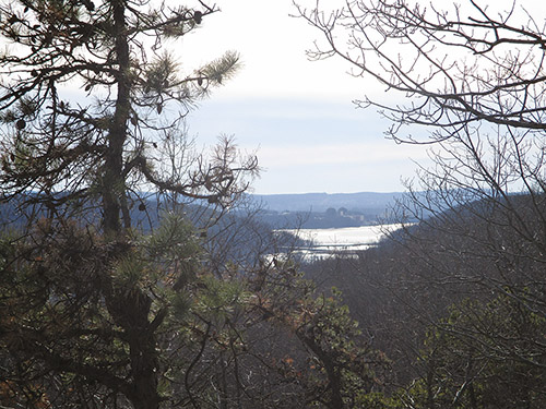
At the top of the rise, you’ll reach a T-intersection. Here, the yellow trail turns left, but you should turn right and follow a trail marked with blue paint blazes for 200 feet to a viewpoint from a rock outcrop. Ahead, you can see the road bridge over Annsville Creek and the Hudson River beyond, with the Indian Point nuclear power plant visible along the river.
When you’ve taken in the view, retrace your steps to the yellow trail and continue straight ahead. In a short distance, you’ll reach a junction with the blue trail (marked by post 2). Turn right, now following both yellow and blue blazes, and descend rather steeply. At post 5, the blue trail leaves to the right, but you should continue ahead on the yellow trail, which crosses a wet area on puncheons and heads north, weaving around rock outcrops.
In a third of a mile, you’ll reach another T-intersection (marked by post 4). The white-blazed Vernal Pool Trail begins on the left, but you should turn right to continue on the yellow trail, which descends to cross a stream on rocks and then begins a steady climb. At the crest of the rise, you’ll reach (to the left of the trail) a rock outcrop studded with pitch pines, with a west-facing view. Although partially obstructed by vegetation, the view from this overlook is slightly broader, and you can see the Metro-North Railroad bridge over Annsville Creek (beyond the road bridge).
After taking in the view, continue along the yellow trail, which traverses moss-covered rocks and passes a glacial erratic on the right. It descends through hemlocks, passes a cliff on the left, and climbs gradually to end at a junction with the white trail. Turn right onto the white trail, which passes rock outcrops on the right, then turns left and descends through mountain laurel to a hollow. Next, it climbs to a rock outcrop with a northwest-facing view (when there are no leaves on the trees).
The white trail now bears left and begins a steady descent, passing a vernal pool (for which the trail is named) on the left. Soon, the trail bears right, and the descent steepens. At the base of the descent, the trail crosses two streams on rocks, with cascades to the right of the second stream crossing. After briefly paralleling the second stream, the trail crosses a wide stone wall and immediately turns left, heading uphill. It turns left onto a woods road and continues to head uphill until it reaches a junction with the blue trail.
Turn right and continue along the blue trail, which now heads downhill on an eroded woods road. At one point, the road becomes very gullied, and the trail is routed to the right to bypass this section of the road. As the trail bears left and crosses the road, the busy Route 9 can be seen and heard directly to the right.
The trail now parallels the road on the opposite side, passing some interesting rock outcrops. It then bears right and descends to the road, where it turns left and once again begins to run along the road. Just ahead, the red trail joins from the right. Continue ahead, now following both blue and red blazes. Soon, you’ll reach a junction marked by post 1, where the yellow trail begins on the left. Continue ahead, following blue and red blazes. You now begin to retrace the route you followed at the start of the hike.
At the next junction, the red trail turns right, but you should turn left and descend on the blue trail. When you reach the start of the loop of the blue trail, turn right and descend rather steeply. After crossing a wet area on puncheons, you’ll arrive at the kiosk on the west side of Sprout Brook Road. Cross the road to reach the parking area where the hike began.
This hiking article is provided by Daniel Chazin of the New York-New Jersey Trail Conference. The Trail Conference is a volunteer organization that builds and maintains over 2,000 miles of hiking trails and publishes a library of hiking maps and books, including Walkable Westchester, a guidebook to trails in Westchester County ($29.95). The Trail Conference’s office is at 600 Ramapo Valley Road (Route 202), Mahwah; (201) 512-9348; www.nynjtc.org. Daniel Chazin can be reached at [email protected].