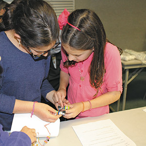

Fifth grade students at RYNJ had the opportunity to participate in a three-part workshop about the workings of a Global Positioning System (GPS). The workshop began with a short video presentation by NASA titled “GPS Satellite Constellation Completed.” Students learned about the creation of the Global Positioning System and how NASA satellites keep GPS working in cars, boats and portable devices around the world. Students then rotated to three different sessions where they discovered how the system of satellites uses trilateration to pinpoint exact locations. Using the concept of trilateration, students used maps and compasses to find the exact location of a “lost” student. Then, students built their own satellite dishes using child-friendly circuit kits. They designed the satellite dishes and tested them to see how much light they could reflect using different materials such as aluminum foil and plastic wrap, to determine which conducts more light. This simulated the information coming from the satellites in space to the dishes on the ground. Students were then exposed to the same type of software that engineers at NASA use to design actual satellites and satellite dishes. This 3-D modeling program, Tinkercad, gave the students a chance to create and manipulate their own digital satellite dishes.


