Harriman State Park, in New York state just north of the border with New Jersey, is a great place to hike. It offers a network of more than 225 miles of marked trails and woods roads, with many interesting features along the trails. This hike begins at the Silvermine Picnic Area, where parking is usually available, even on weekends, but you might want to get an early start to ensure that you can find a parking space on busy weekends.
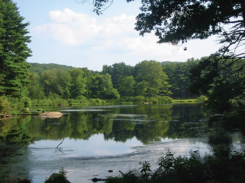
This 5.2-mile hike climbs more than 600 vertical feet on a moderate grade to the top of Stockbridge Mountain, and you’ll pass a historic iron mine along the way. At the top of the mountain, you can see a stone shelter and an interesting overhanging rock. You’ll also hike along the shore of Lake Nawahunta on the return leg of the hike. Dogs are permitted on leash.
To reach the trailhead, follow N.J. Route 17 north to the New York State Thruway and take the first exit, Exit 15A (the village of Sloatsburg). Just past the village, turn right at the traffic light and follow the sign for Seven Lakes Drive/Harriman State Park. Continue along Seven Lakes Drive for about 12 miles to the Silvermine Picnic Area, on the right side of the road (the Silvermine Picnic Area is 2.1 miles beyond the Tiorati Circle). Park in the southwest corner of the large parking area.
From the parking area, proceed west (parallel to Seven Lakes Drive) on a wooded road that goes through a picnic area, following the yellow blazes of the Menomine Trail. Just beyond a cable barrier, the trail turns right, climbs a slope, crosses a paved road (the entrance road to an abandoned parking area for the former Silvermine Ski Area) and enters a pine grove. On the right is a stone marking the grave of James H. (“Scobie Jim”) Lewis, who once farmed the area now covered by Lake Nawahunta.
Follow the Menomine Trail as it crosses Seven Lakes Drive and continues ahead on a wooded road, known as the Nawahunta Fire Road. After passing a cellar hole (believed to be the remains of the Lewis family home) on the left, you’ll come to a fork. Here, the yellow-blazed Menomine Trail bears left, but you should take the right fork, leaving the blazed trail, to continue on the unmarked woods road.
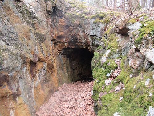
In another 700 feet, you’ll notice a small cairn on the right side of the trail and an unmarked trail leading to the right. There, in about 50 feet, is a rock cut angled into the hillside which marks the Lewis Mine (there are also scattered tailings––small pieces of discarded rock––in front of the mine). After exploring this interesting feature, continue ahead on the pleasant grassy woods road (built by the park as a fire road in 1954). The road climbs gradually for about a mile, then descends for a quarter of a mile.
At the base of the descent, turn sharply left (south) onto the aqua-blazed Long Path (if you were to head north, you’d find that the Long Path joins the fire road). Follow the aqua blazes through a low-lying area, and be aware of some wet sections. The trail crosses an underground stream, then begins to climb steadily.
After reaching a high point and descending a little, you’ll cross a relatively level area. A rock ledge marks the end of the level area. Here, on the left is the Stockbridge Cave Shelter––a natural rock overhang, with a stone fireplace built in.
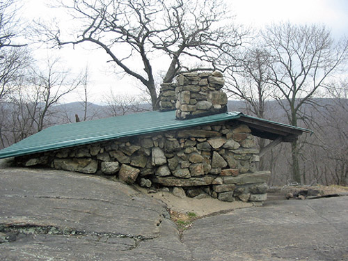
The Long Path steeply climbs the ledge, levels off briefly, then climbs a little more to reach the northern summit of Stockbridge Mountain (elevation 1,320 feet), with west-facing views from rock ledges to the right. Just beyond, you’ll descend slightly to reach the stone Stockbridge Shelter, built in 1928. Overnight camping is allowed at the shelter. The Long Path now steeply descends a rock ledge and continues down to a level area, where a triple-yellow blaze marks the start of the Menomine Trail.
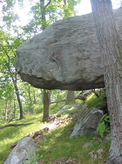
Continue straight ahead on the Long Path for another 750 feet to the overhanging boulder known as Hippo Rock, which is just off the trail on your right. After observing this interesting geological feature, retrace your steps back to the Menomine Trail.
Turn right onto the Menomine Trail, which descends on an old wooded road. It soon bears left and levels off, then turns right and resumes its descent. After leveling off, the trail passes through a pine grove and crosses the outlet of Lake Nawahunta. The trail briefly parallels the lake, then bears right onto the Nawahunta Fire Road, which it follows to Seven Lakes Drive.
Now retracing your steps, follow the yellow blazes across the road and back to the parking area where the hike began.
This hiking article is provided by Daniel Chazin of the New York-New Jersey Trail Conference. The Trail Conference is a volunteer organization that builds and maintains over 2,000 miles of hiking trails and publishes a library of hiking maps and books. The Trail Conference’s office is at 600 Ramapo Valley Road (Route 202), Mahwah; (201) 512-9348; www.nynjtc.org. Daniel Chazin can be reached at [email protected].
By Daniel Chazin
�