

This 4.5-mile loop hike in Harriman State Park climbs to three very interesting features—the ruins of a mansion known as ORAK, the Jackie Jones Fire Tower (the only remaining fire tower in Harriman) and the Big Hill Shelter. There are a number of ups and downs, and the total elevation gain of the hike is about 1,000 vertical feet. Allowing some time to explore these special features, the hike should take about 3 1/2 hours. Dogs are allowed on leash.
The recent hurricane felled a number of trees along the route of this hike; however, all blowdowns can be easily walked over or around.
To reach the trailhead, take the Palisades Interstate Parkway north to Exit 14 and turn left onto Willow Grove Road (County Route 98). In about 1 1/2 miles, the road joins County Route 106, which comes in from the right. Continue for another three-tenths of a mile, and park in a parking area on the left, just before crossing a bridge over a stream.
From the parking area, walk west along Route 106 for 300 feet, crossing over Minisceongo Creek. Turn left at the gated paved road and proceed uphill on the road, following the yellow blazes of the Suffern-Bear Mountain (S-BM) Trail. You will be following the S-BM Trail for the next two miles—all the way to the Big Hill Shelter.
In a short distance, the S-BM Trail bears left onto a crumbling paved road and soon reaches the stone ruins of a large estate. Known as ORAK, the mansion was built in 1923 by George Briggs Buchanan, a vice president of the Corn Products Refining Company, which manufactured Karo syrup (Orak is Karo spelled backwards). After Buchanan died in 1939, his heirs sold the mansion to the park, and it was demolished in 1973. Use caution if you wish to explore the ruins of this mansion.
The S-BM Trail now bends to the right and levels off on a woods road through mountain laurel thickets. A short distance beyond, a large blowdown obscures the trail. Bear right and follow an informal footpath around the blowdown, then turn right on another woods road to continue on the yellow-blazed S-BM Trail.
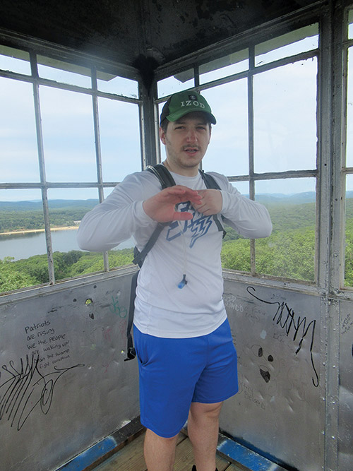
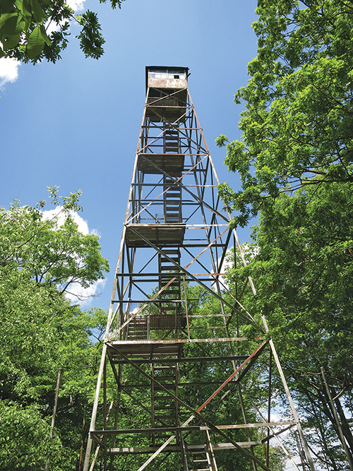
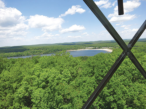
Just ahead, the trail bears left, leaving the woods road, and climbs to a large open rock ledge. A short distance beyond, it passes communications towers on the right and soon arrives at the 1,276-foot summit of Jackie Jones Mountain, marked by a steel fire tower. Built in 1928, the 60-foot-high tower was restored in 2018 by volunteers of the New York State Chapter of the Forest Fire Lookout Association and Team Rubicon. You can climb the tower to obtain panoramic views over Lake Welch to the north and the Hudson River to the southeast. On a clear day, you can see the New York City skyline to the south.
The S-BM Trail now descends, steeply in places. After crossing a stream, it climbs a little and then resumes its steep descent. At the base of the descent, it crosses another stream and then the Old Turnpike—a wide woods road, which is now the route of a gas pipeline. A short distance beyond, it reaches a junction with the aqua-blazed Long Path, which comes in from the left.
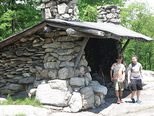
Continue ahead on the joint S-BM/Long Path, which turns right onto a woods road. Soon, the joint trails turn left and climb to the Big Hill Shelter. Built in 1927, this stone shelter offers a panoramic view to the south, with the New York City skyline visible in the distance on a clear day. This is a good place to take a break.
When you’re ready to continue, go back and descend on the S-BM/Long Path, following the same route you took up to the shelter. When you reach the fork where the two trails diverge, bear right and continue on the aqua-blazed Long Path. After descending a little, the Long Path climbs gradually and then begins a steady descent, passing a vernal pond along the way. At the base of the descent, the trail crosses a stream and bears right. Just ahead, you’ll reach the wide Old Turnpike, with posts marking its use as a gas pipeline.
Leave the Long Path route here and turn left onto the Old Turnpike, which heads uphill for about 500 feet. At the crest of the rise—just before reaching a post with the number 712—turn right onto an unmarked woods road, which heads north, uphill. In about three-tenths of a mile, you’ll reach a junction with the yellow-blazed S-BM Trail. The yellow blazes head both right and straight ahead, but you should turn right, now retracing your steps along the S-BM Trail. Follow the trail downhill past the ruins of ORAK and back to Route 106, then turn right on Route 106 to reach the parking area where the hike began.
This hiking article is provided by Daniel Chazin of the New York-New Jersey Trail Conference. The Trail Conference is a volunteer organization that builds and maintains over 2,000 miles of hiking trails and publishes a library of hiking maps and books, including a two-map set for Harriman-Bear Mountain Trails ($10.95). The Trail Conference’s office is at 600 Ramapo Valley Road (Route 202), Mahwah;� (201) 512-9348; www.nynjtc.org. Daniel Chazin can be reached at [email protected].