


This 5.3-mile “lollipop”-loop hike in the Delaware Water Gap National Recreation Area in Warren County follows a beautiful footpath through dense thickets of mountain laurel and rhododendron and climbs to the Appalachian Trail on the Kittatinny ridge, which offers panoramic views. Although the hike is not exceptionally difficult, it involves a total elevation gain of about 350 feet, with few rather steep sections. It should take about three and a half hours, and dogs are allowed on leash.
To get there, take I-80 West to Exit 12 (Blairstown/Hope). Turn right at the bottom of the ramp and follow County Route 521 north for 4.7 miles to N.J. Route 94. Turn left onto Route 94 and follow it for 0.2 mile to a traffic light. Turn right at the traffic light, but then continue straight ahead on Bridge Street (do not follow signs for Route 521, which immediately makes a second right). Proceed to a stop sign at the top of the hill, turn sharply right, then almost immediately turn left onto Millbrook Road. Follow Millbrook Road for 6.2 miles until you reach the crest of the Kittatinny Ridge. The hike begins where the white-blazed Appalachian Trail crosses Millbrook Road and heads south. Here, a gravel road, blocked by a gate (marked “Fire Road—Do Not Block”), goes off to the left. GPS coordinates: 41.058035,-74.964248. Limited parking is available at the trailhead, but if no spaces are available, continue ahead for another 500 feet to a second parking area on the right side of the road. The trailhead is about 70 miles from Teaneck, and it should take about one hour and 15 minutes to get there.
From the gate, proceed ahead on the gravel road, marked with the white blazes of the Appalachian Trail (A.T.). In about a quarter of a mile, the road curves sharply right and enters a rhododendron grove. A short distance beyond, the white blazes of the A.T. leave to the left, but you should continue ahead along the gravel road.
About 300 feet beyond the A.T. turnoff, you will see a triple-orange blaze and a sign for the Rattlesnake Swamp Trail on the right side of the road. Turn right, leaving the road, and enter the woods on a footpath. The trail proceeds through a dense forest of mountain laurel, hemlock and rhododendron, with the swamp on your right and a secondary ridge beyond. You are now traversing a wild, remote area (although you probably won’t encounter any rattlesnakes).
At one point, the trail detours to the left, climbing a little further up the hill to avoid a wet section of the former trail route. When the trail goes back down to the level of the swamp, you’ll tunnel under dense rhododendron thickets and then cross a stream, the inlet of Catfish Pond, on rocks. Soon, the swamp ends, the vegetation becomes less dense and the trail descends a little.
After crossing the stream three more times, the Rattlesnake Swamp Trail approaches Catfish Pond, which may be visible through the vegetation to the right. It does not reach the shore of the pond, though, and it soon bears left, away from the pond. The trail emerges onto a woods road, which it follows, past an abandoned concrete slab on the right, to a T-intersection. To the right, the road leads to the Mohican Outdoor Center, operated by the Appalachian Mountain Club, which offers lodging to hikers (for more information, go to www.outdoors.org/lodging-camping/Lodges/mohican/index.cfm), but you should turn left, continuing to follow the orange blazes.
The trail now begins a gradual climb up the Kittatinny Ridge, following a woods road with a rocky treadway. After a while, the grade steepens as the trail narrows to a footpath and climbs rock steps. The trail then levels off, only to climb again. Finally, after another level stretch, you’ll climb once more to reach the crest of the ridge. The Rattlesnake Swamp Trail now descends briefly, and it ends at a junction with the A.T. on the eastern face of the Kittatinny Ridge.
The rock ledges at the junction afford panoramic east-facing views over the Great Valley. To the south, you can see the Upper and Lower Yards Creek Reservoirs, which are pumped-storage facilities used to generate electricity. This is a good place to take a break and enjoy the view.
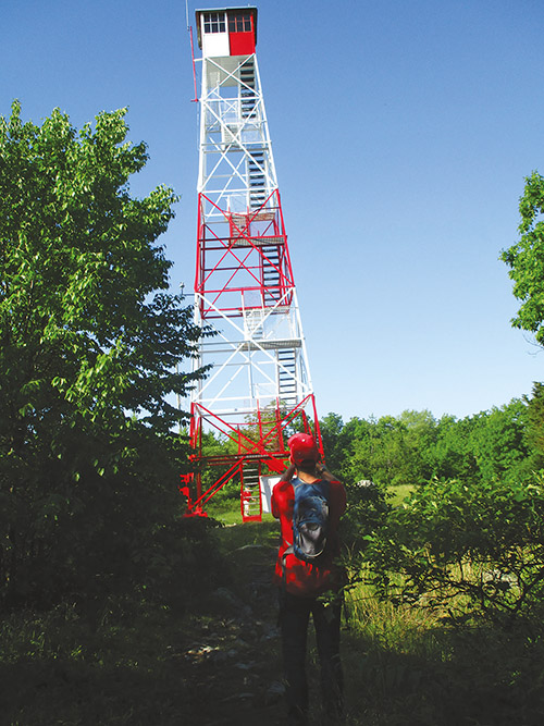
When you’re ready to continue, proceed north along the A.T. The trail runs close to the edge of the ridge, with more views over the Great Valley to the east. In another mile, you’ll reach the base of the 60-foot-high Catfish Fire Tower, which offers panoramic 360° views.
From the fire tower, the A.T. begins to descend along a gravel road (the access road to the tower). Soon, the white blazes turn left, leaving the road, and descend on a rocky footpath. Continue to follow the white-blazed A.T., which will lead you back to the starting point of the hike. After briefly rejoining the road, the A.T. again leaves the road, this time to the right, and follows a footpath downhill. The trail goes under power lines, passes through a dense rhododendron thicket, and reaches another junction with the road. Turn right, now retracing your steps along the road you followed at the start of the hike. In another ten minutes, you’ll reach the trailhead where the hike began.
This hiking article is provided by Daniel Chazin of the New York-New Jersey Trail Conference. He can be reached at DChazin@aol.com.


