When thinking about possible hiking destinations in Bergen and Passaic Counties, Paterson is probably not a location that comes to mind. Yet this three-mile hike around Garret Mountain in Paterson and Woodland Park is one of the most interesting hikes in the area, as it features spectacular views of the New York City skyline. You’ll also pass the stone observation tower of the Lambert Castle and walk along the scenic Barbour Pond. Although there are a few steep sections, for the most part, the hike features gentle grades. Allow about 2 1/2hours for the hike, which includes time to stop and admire the views of the skyline. Dogs are permitted on leash, and a free trail map (without contours) is available online at www.nynjtc.org/map/garret-mountain-reservation-trail-map�
To reach the trailhead, take I-80 west to Exit 56 (Squirrelwood Road/Woodland Park/Paterson). Turn left at the bottom of the ramp onto Squirrelwood Road. (If you are coming from the west, take Exit 56A and proceed south on Squirrelwood Road.) Continue along Squirrelwood Road for 0.7 miles, then turn left onto Mountain Avenue at the New Street Reservoir. In 0.3 miles, you will reach the entrance to Garret Mountain Reservation on the right. Turn right and continue along the park road for 0.4 mile to the parking area for the Pat Di Ianni Boat House, on the right. Turn right and park in the parking area.
From the parking area, follow the path downhill to a lawn at the southern end of Barbour’s Pond, and turn left onto a wide macadam path, passing to the left of a stone building and a smaller maintenance building. As you pass the entrance to the smaller building, you’ll reach the Yellow Trail. Turn left onto the Yellow Trail, which you will follow for the entire hike.
The trail parallels a stream on the right. Continue ahead where the road branches off to the left. A short distance beyond, the trail turns left, away from the stream, and begins to climb. You’ll pass abandoned concrete picnic tables on the left and an abandoned shelter (as well as a newer building) on the right. The trail climbs a rise and—just before reaching a paved road—turns sharply left and descends to cross Park Road, the main road that circles the park. Just beyond, it reaches a junction with the White Trail, which begins here. Follow the yellow blazes, which turn right on a wide gravel path.
In another 250 feet, as the gravel path bears left, the Yellow Trail continues straight ahead, climbing an embankment and again crossing the paved road. The trail turns right and runs parallel to the road (do not follow the paved road leading to the park stables). At the next intersection, the trail bears left and continues parallel to the paved Weasel Drift Road.
Just before reaching the park boundary, the yellow blazes turn left, leaving the road and ascending into the woods on a footpath. With the access road to the stables visible ahead, the trail bears right, passes between abandoned concrete tank supports, and begins to run along the ridge of Garret Mountain, with the stables to the left. At the end of the stables, the trail bears left, makes a short but steep descent, and then turns right, continuing along the ridge.
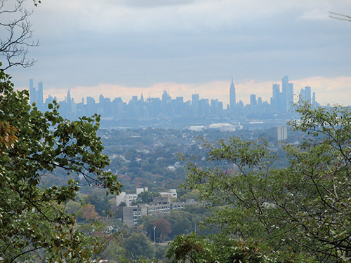
About 0.2 miles beyond the stables, the trail reaches an unobstructed viewpoint to the east from the edge of the ridge. Clifton, as well as the southern part of Paterson, may be seen directly below, with much of southern Bergen County beyond, and the Manhattan skyline clearly visible in the distance. The Verrazano-Narrows Bridge is at the extreme right of this broad panorama. This is a good place to take a break while enjoying the spectacular view.
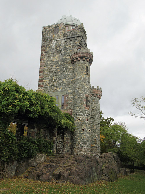
The trail continues north along the ridge, passing several more viewpoints. Soon, you’ll reach a stone observation tower, built in the 1890s by a wealthy silk manufacturer as part of Lambert Castle, at the base of the mountain. The trail skirts to the right of the tower, following a stone wall.
Beyond the tower, the Morris Canal Greenway Trail (marked with canal-boat-logo-on-yellow blazes) joins from the right at a break in the stone wall. Follow both the yellow and the Greenway logo blazes, which curve to the right (do not descend on the macadam path). Soon, the trail descends on a rocky path and stone steps, and it briefly parallels the paved park road.
About 0.2 miles from the tower, a side trail to the right leads to another expansive viewpoint to the east from the edge of a cliff. A police firing range is located directly below, so don’t be startled if you hear gunshots. Just beyond, the trail passes a small gravel parking area on the left. It enters the woods on a footpath, then emerges onto a grassy field and follows along its right side.
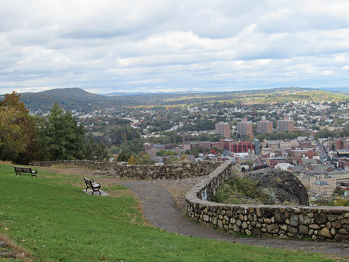
At the end of the field, the Yellow Trail and the Greenway Trail, descend on a footpath to the entrance to an overlook. Here, the White Trail and the Greenway Trail leave to the right. It is worth making a short detour to the overlook, which affords a panoramic view over downtown Paterson (directly below) and High Mountain to the north.
After taking in the view, return to the entrance to the overlook and turn right to continue on the Yellow Trail, which follows a macadam path parallel to Park Road. On the left, you’ll pass a plaque honoring Robert Dix Benson, the first President of the Passaic County Park Commission. At the next intersection, follow the Yellow Trail as it bears right and climbs along a paved road that leads to Veterans Memorial Point, the site of a communications tower.
Just beyond a guardrail barrier at the end of the paved road, the trail bears left and descends into the woods. A quarter of a mile beyond, after crossing the White Trail, the Yellow Trail climbs over a small rise and descends, first gradually, then more steeply on switchbacks.
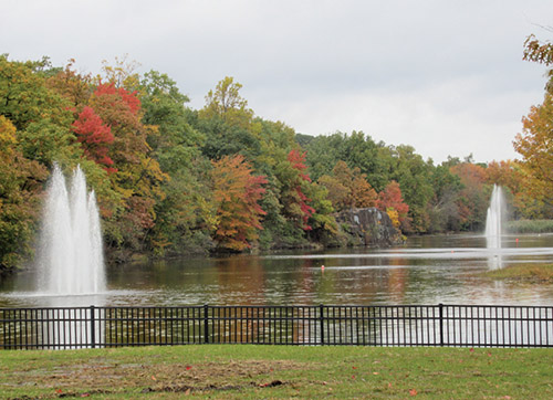
At the base of the descent, the trail goes across a grassy area, then crosses the park entrance road at a kiosk. It turns right, passes through an opening in a wooden fence and begins to parallel Mountain Avenue. After crossing its outlet stream on a wooden footbridge, the trail runs along the west side of Barbour Pond. At the end of the pond, bear left at a fork, proceed across a footbridge and continue across the lawn and up the hill to the parking area where you began the hike.
This hiking article is provided by Daniel Chazin of the New York-New Jersey Trail Conference. The Trail Conference is a volunteer organization that builds and maintains more than 2,000 miles of hiking trails and publishes a library of hiking maps and books. The Trail Conference’s office is at 600 Ramapo Valley Road (Route 202), Mahwah; (201) 512-9348; www.nynjtc.org. Daniel Chazin can be reached at [email protected].
By Daniel D. Chazin