


This easy 2.8-mile hike follows an abandoned railbed, climbs an inclined plane of the historic Morris Canal and continues along a half-mile stretch of the canal’s towpath. It offers an opportunity to explore the remnants of two historic methods of transportation, while enjoying a delightful hike. Apart from occasional logo blazes of the Morris Canal Greenway, there are no markers along the route of the hike, but the route is obvious and easy to follow.
When the Morris Canal was completed in 1831, it was the only means of transportation available to transport bulky commodities, such as coal and iron ore, across New Jersey. In order to traverse the Highlands of northern New Jersey, the canal had to climb from sea level to elevation 914 feet at Lake Hopatcong (and then descend 760 feet to the Delaware River). Locks were the traditional means of lifting boats from one canal level to another, but a lock can lift a boat only about 10 feet. To enable the canal to be constructed without an inordinate number of locks, inclined planes were employed. Turbines powered by water were attached to cables that pulled the boats—resting on cradle cars—up and down the plane. Only a few inclined planes were preserved when the canal was abandoned in 1924, and this hike offers you the opportunity to walk up Plane 4 West, with an elevation gain of 77 feet.
To reach the trailhead, take I-80 West to Exit 25. Proceed north on U.S. Route 206 for 1.5 miles, and turn left onto Waterloo Road. In 1.1 miles, turn sharply left onto Continental Drive. Follow Continental Drive for 0.2 mile, crossing a bridge over the Musconetcong River, and park along the shoulder of the road just beyond the bridge.
From the trailhead, 60 feet south of the end of the guardrail leading from the bridge over the river, enter the woods on a footpath at a sign for the “trail” and a logo blaze of the Morris Canal Greenway. Just ahead, bear right at a fork onto a woods road. At the next intersection, continue along the road as it curves to the right, following the sign to “RR Plane 4W.” Along the way, you’ll cross two streams on wide wooden bridges.
About two-thirds of a mile from the start, the road bears left onto the right of way of the abandoned Sussex Railroad. Built in 1854 to transport iron ore from local mines to a furnace in Pennsylvania, this portion of the railroad was abandoned in 1900, when a line to Netcong replaced the original route to Waterloo. Although this portion of the railroad was abandoned over 120 years ago, the right of way is in remarkably good condition. Follow the railbed over an embankment, through a cut, and then over another embankment, with a valley below on the right.
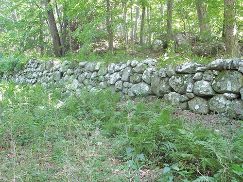
After descending a little, you’ll arrive at the base of the plane, where you will notice rock walls on the left, bordering each side of the plane (which was carved into the hillside). Turn left and climb up the plane. About halfway up, you’ll notice stone abutments on each side of the plane. These abutments supported the tracks of the Sussex Railroad, which crossed over the plane on its way to its original terminus at Waterloo.
As you reach the top of the plane, you’ll notice clumps of tar on the ground. These are the remains of the tar that was used to lubricate the cables. You’ll also notice rows of rectangular stones, known as “sleepers,” which supported the rails used to guide the cradle car along the plane. And just beyond the summit of the plane, in a pile of rocks, you’ll find remnants of the actual cables used to pull the boats up the plane.
The walking route now curves to the right and begins to follow the canal towpath—the raised embankment used by the mules, which pulled the boats along the canal. The dry canal prism is just to your left. Unfortunately, you can now hear and see the traffic on I-80, just to your right. The juxtaposition of the historic canal with the contemporary superhighway is certainly interesting, though.
In about half a mile, follow the walking route as it turns left, leaving the towpath, descends to the canal prism and continues to descend on footpath to a junction with the woods road. Continue ahead at the junction (following the sign to “Cont. Rd.”) and retrace your steps to the trailhead.
This hiking article is provided by Daniel Chazin of the New York-New Jersey Trail Conference. The Trail Conference is a volunteer organization that builds and maintains over 2,000 miles of hiking trails and publishes a library of hiking maps and books. The Trail Conference’s office is at 600 Ramapo Valley Road (Route 202), Mahwah; (201) 512-9348; www.nynjtc.org. Daniel Chazin can be reached at [email protected]


