
This three-mile easy-to-moderate hike in Garret Mountain Reservation in eastern Passaic County is one of the most interesting hikes in the area. It includes spectacular views of the New York City skyline and passes the historic stone observation tower of the Lambert Castle. Although there are a few rather steep sections, for the most part the hike features gentle grades. Allow about two hours for the hike, which includes time to stop and admire the views of the New York City skyline. Dogs are permitted on leash, and a free trail map (without contours) is available online at www.nynjtc.org/map/garret-mountain-reservation-trail-map.
To reach the trailhead, take I-80 west to Exit 56 (Squirrelwood Road/Woodland Park/Paterson). Turn left at the bottom of the ramp onto Squirrelwood Road. (If you are coming from the west, take Exit 56A and proceed south on Squirrelwood Road.) Continue along Squirrelwood Road for 0.7 mile, then turn left onto Mountain Avenue at the New Street Reservoir. In 0.3 mile, you’ll reach the entrance to Garret Mountain Reservation on the right. Turn right and continue along the park road for 0.4 mile to the parking area for the Pat Di Ianni Boat House, on the right. Turn right and park in the parking area. The reservation is about 13 miles from Teaneck and it should take about 20 minutes to get there.
As you enter the parking area, you’ll cross a gravel bridle path. To begin the hike, walk up to the bridle path and turn right. Follow the bridle path as it curves left, crosses the main park road, and heads uphill, soon reaching a four-way intersection. Continue ahead, now following the Yellow Trail, which comes in from the right.

In another 250 feet, as the gravel bridle path bears left, the Yellow Trail continues straight ahead, climbing an embankment and crossing the paved park road. The trail turns right and runs along a grassy strip parallel to the road (do not follow the paved road between stone gate posts that leads ahead to the park stables). At a split-rail fence, the trail bears left and continues parallel to the paved Weasel Drift Road.
Just before reaching the park boundary, the yellow blazes turn left, leaving the road, and ascend into the woods on a footpath. With the access road to the stables visible on the left, the trail bears right, passes between abandoned concrete tank supports, and begins to run along the ridge of Garret Mountain, passing the stables on the left. At the end of the stables, the trail bears left, makes a short but steep descent, then turns right, continuing along the ridge.
You’re now walking on an outcrop of the volcanic igneous rock that forms the Watchung mountain range. This rock, known as basalt, was formed when molten lava extruded out onto the earth’s surface and cooled rapidly. It is completely different from the metamorphic rock found in the nearby Highlands (and also distinguishable from the igneous rock of the Palisades, known as diabase, which cooled more slowly underground).
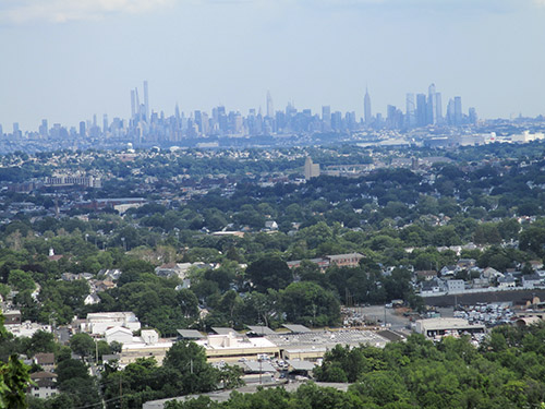
About 1,000 feet beyond the stables, the trail reaches an unobstructed viewpoint to the east from the edge of the ridge. Clifton, as well as the southern part of Paterson, may be seen directly below, with much of southern Bergen County beyond, and the Manhattan skyline clearly visible in the distance. The Verrazano-Narrows Bridge is at the extreme right of this broad panorama. This is a good place to take a break while enjoying the spectacular view.

The trail continues north along the ridge, passing several more viewpoints. Soon, you’ll reach a stone observation tower, built in the 1890s by a wealthy silk manufacturer as part of Lambert Castle, at the base of the mountain. The trail skirts to the right of the tower, following a stone wall.
Beyond the tower, the Morris Canal Greenway Trail (marked with canal-boat-logo-on-yellow blazes) joins from the right at a break in the stone wall. Follow both the yellow and the Greenway logo blazes, which curve to the right (do not descend on the macadam path). Soon, the trail descends on a rocky path and stone steps, and it briefly parallels the paved park road.
As the road curves left, away from the trail, an unmarked side trail to the right leads to another expansive viewpoint to the east from the edge of a cliff. A police firing range is located directly below, so don’t be startled to hear gunshots! Just beyond, the trail passes a small parking area on the left, reenters the woods, then emerges in an open area, passing a gazebo and a fenced-in playground on the left.
The Yellow Trail continues ahead, passing stone benches on the left, then bears left, reenters the woods, and descends to a paved road leading into a parking area for an overlook. (Note: As of this writing, the trail is not well marked in the area of the stone benches. If you cannot find the continuation of the trail, head west to the main park road, turn right at the flagpole, and continue along the paved path.) Here, the Yellow Trail bears left, but you should turn right, now following the White Trail (as well as the Greenway logo blazes), which proceeds along a paved path on the right side of the overlook. The trail turns right and descends stone steps, then turns left and follows the stone wall along the edge of the overlook. The view to the south and east is more limited here, but downtown Paterson is visible directly below, and High Mountain may be seen to the north.

At the end of the wall, follow the White Trail as it descends into the woods on a footpath. At the base of the descent, the Morris Canal Greenway Trail leaves to the right, crossing an intermittent stream, but you should turn left and follow the White Trail, which begins to climb. The trail soon turns right onto a woods road, but in 100 feet, at a huge boulder, the trail turns left, leaving the woods road, and continues to climb on a footpath.
After leveling off, the White Trail reaches a junction with the Yellow Trail at a rock ledge that overlooks a ravine on the right. Follow the White Trail as it turns left and descends to a gravel parking area along the paved park drive. Here, the trail bears right, turns left to cross the park drive, and continues ahead on a gravel road. In 200 feet, the white blazes bear left at a fork and follow a grassy strip and then a gravel bridle path. The White Trail then turns right onto another bridle path, passing a line of unusual flat-sided boulders on the left.
After curving to the left, the White Trail bears right at a fork and continues along the wide bridle path. It proceeds along a shaded route through a little-used area in the middle of the park. Follow the White Trail along the bridle path for another half mile until it ends at a junction with the Yellow Trail. Turn right at this four-way intersection and follow the unmarked bridle path back to the parking area where the hike began.
This hiking article is provided by Daniel Chazin of the New York-New Jersey Trail Conference. The Trail Conference is a volunteer organization that builds and maintains over 2,000 miles of hiking trails and publishes a library of hiking maps and books. The Trail Conference’s office is at 600 Ramapo Valley Road (Route 202), Mahwah; (201) 512-9348; www.nynjtc.org. Daniel Chazin can be reached at [email protected].


