


This 3.8-mile moderate hike in the Ramapo Valley County Reservation climbs to a panoramic viewpoint over the New York City skyline, passes a waterfall, and follows the shore of a scenic reservoir. The hike should take about two and a half hours. Dogs are allowed on leash.
To get there, take N.J. Route 17 North to U.S. Route 202 in Mahwah. Turn left at the bottom of the ramp, proceed south on Route 202 for 2.0 miles, and turn right into the Ramapo Valley County Reservation parking area. GPS address: 608 Ramapo Valley Road, Mahwah, NJ 07430. The trailhead is 20 miles from Teaneck, and it should take about 25 minutes to get there.
The hike begins at a kiosk in the southwest corner of the parking area. Just ahead, you’ll notice a triple-black-square-on-yellow blaze on a tree, which marks the start of the Vista Spur Trail. Follow the black-square-on-yellow blazes as they descend wooden steps, join a wide dirt road, and continue ahead to cross the Ramapo River on a steel truss bridge. Just beyond the bridge, you’ll pass one end of the orange-on-white-blazed River Loop Trail on the left and, in another 250 feet, you’ll pass the other end of this loop, but you should continue ahead on the wide dirt road, following the black-square-on-yellow blazes along the southern shore of Scarlet Oak Pond (formerly the site of a gravel quarry).
At the end of the pond, a triple-blaze marks the terminus of the Vista Spur Trail. Continue ahead on the wide dirt road. In 125 feet, a triple-yellow blaze marks the start of the Vista Loop Trail. Then, in another 75 feet, the Vista Loop Trail turns right, but you should proceed ahead on the wide dirt road, now following the blue/yellow-blazed Vista-Ridge Connector, which begins here.
The Vista-Ridge Connector curves to the left and climbs gradually on the main park road. In a third of a mile, you’ll notice on the left two sets of triple blazes, which mark the end of the Vista-Ridge Connector and the start of the blue-blazed Ridge Loop Trail. Continue ahead on the Ridge Loop Trail (do not turn left) and head uphill on a footpath with wooden steps. Just ahead, the blue blazes turn left onto a woods road, which ascends on a slightly steeper grade.
After curving to the left, the Ridge Loop Trail reaches a fork. Turn left here and follow the yellow-blazed Vista Loop Trail for about 200 feet. When the yellow blazes turn sharply right, continue ahead, following black-star-on-yellow blazes a short distance to a panoramic southeast-facing viewpoint from a rock ledge. Campgaw Mountain may be seen in the foreground to the right, and the New York City skyline is visible in the distance on a clear day.
After taking in the view, retrace your steps to the yellow-blazed trail and turn left, following the trail as it descends steadily. Just before reaching a large pile of boulders, the trail turns right and climbs to a rocky outcrop with a single cedar tree, from which Matty Price Hill is visible ahead. The trail now descends towards the MacMillan Reservoir, passing another rocky outcrop (with a view of Matty Price Hill) along the way.
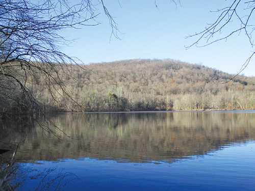
At the base of the descent, you’ll emerge on a large expanse of open rock that overlooks the reservoir. Here, the yellow-blazed Vista Loop Trail turns left, but you should turn right onto the pink-blazed Reservoir Loop Trail, which heads north along the eastern shore of the reservoir. As you approach the northern end of the reservoir, the trail closely parallels the shore, then crosses a wooden footbridge over a stream, built as an Eagle Scout project in 2018.
At the northern tip of the reservoir, a massive boulder on the left marks a spot where a flat rock that juts into the reservoir affords a panoramic view. A short distance beyond, the trail reaches a wooden footbridge over the inlet of the reservoir. Turn right just before the bridge, leaving the Reservoir Loop Trail, and head west on the blue/pink-blazed Brookside Trail, which parallels the inlet. Along the way, the trail approaches a rocky gorge on the left, with a beautiful waterfall when the water is high.
After curving to the right, the Brookside Trail ends at a junction with the blue-blazed Ridge Loop Trail. Turn left and follow the Ridge Loop Trail, which crosses the inlet of the reservoir on rocks and begins a steady climb. The trail bears left at a junction with the red/silver-blazed Rocky Mountain Connector (which begins on the right).
Just beyond a stream crossing on a culvert, the red-blazed Marsh Loop Trail crosses. Turn left onto the red-blazed Marsh Loop Trail, which descends steadily on a footpath through attractive woods, passing to the right of a deep ravine. It curves to the right and ends at a junction with the pink-blazed Reservoir Loop Trail near the shore of the MacMillan Reservoir.
Turn right and follow the Reservoir Loop Trail along the southwestern side of the reservoir. After running for some distance close to the shore, the Reservoir Loop Trail ends at a junction with the blue-blazed Ridge Loop Trail, just south of the dam.
Proceed ahead (downhill) on the Ridge Loop Trail, which follows the wide park road. Soon, the yellow-blazed Vista Loop Trail joins from the left. Continue ahead on the road, now following both blue and yellow blazes. When the trails diverge at a sign for the “waterfall,” bear left to stay on the blue-blazed Ridge Loop Trail.
A short distance ahead, you’ll reach a junction where a triple-blue blaze marks the end of the Ridge Loop Trail. Here, you should bear right and follow the blue/yellow-blazed Vista-Ridge Connector downhill along the park road. Near the base of the descent, the Vista-Ridge Connector curves to the right, and it ends just beyond. Proceed straight ahead, now following the black-square-on-yellow-blazed Vista Spur Trail, which passes to the right of Scarlet Oak Pond, continues across the bridge over the Ramapo River, and ends at the parking area where the hike began.
This hiking article is provided by Daniel Chazin of the New York-New Jersey Trail Conference. The Trail Conference is a volunteer organization that builds and maintains over 2,000 miles of hiking trails and publishes a library of hiking maps and books. The Trail Conference’s office is at 600 Ramapo Valley Road (Route 202), Mahwah; (201) 512-9348; www.nynjtc.org. Daniel Chazin can be reached at [email protected].


