


It certainly isn’t wilderness, and some might feel that it’s much too close to civilization to be considered “hiking.” But the Bronx River Pathway has its own special charm, and its gentle grades and accessibility by public transportation appeal to many people who are looking for an easy hike. And even if you drive to the start of the hike, you can take a train back to your starting point!
The Bronx River Pathway came into being in 1925 as part of the Bronx River Reservation, which was created to clean up a 13-mile stretch of the Bronx River in Westchester County. The planners thought it important to include both a “drive” for motor vehicles (today’s parkway) and a path for pedestrians and bicyclists. The pathway weaves between the parkway, the river and the railroad (now the Harlem Line of Metro-North). Although there are places where you walk close to the parkway, for much of the way the pathway is some distance away, with the parkway often shielded from view by vegetation.
This hike covers the 5.3-mile stretch of the pathway from the Kensico Dam to Hartsdale, with the return trip by Metro-North train. It should take about two and one-half hours to cover the distance (not including the return train trip). Except for the last mile approaching Hartsdale, the pathway is paved for its entire length. Dogs are permitted on leash.
To reach the trailhead from Bergen County, cross the Tappan Zee Bridge and continue onto I-287 East. Take Exit 6 (White Plains/North White Plains). At the end of the ramp, turn left onto NY Route 22, then (after crossing over I-287) immediately turn left onto Cemetery Road. In 0.3 mile, turn right onto the Bronx River Parkway and follow it to its end at the Kensico Dam Plaza, where parking is available. Kensico Dam Plaza is about 35 miles from Teaneck, and it should take about 45 minutes to get there.
If coming from Riverdale, take I-87 North to I-287 East. Continue on I-287 to Exit 6 and follow the directions above.
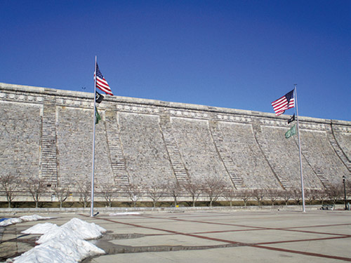
The pathway begins on the east side of Kensico Dam Plaza, near the steps to the top of the dam. It heads south, passing The Rising, a memorial to Westchester County residents who were killed in the terrorist attacks on the World Trade Center on September 11, 2001. At the entrance to the plaza, it crosses the access road to Route 22 and turns left to parallel it. After going beneath an overpass, the pathway turns right and passes ballfields on the left. It crosses Washington Avenue North and goes over the Valhalla Viaduct, which spans the Metro-North railroad tracks. A plaque in the stonework of the viaduct—designed to look like a suspension bridge—gives details of the construction of the parkway, which was dedicated at this viaduct in 1925.
The pathway now turns left and follows an attractive wooded section between the railroad and the parkway. Soon it crosses a footbridge over the Bronx River—the first of many crossings of the river. It crosses Virginia Road at 1.0 mile and then Parkway Homes Road, which leads to the Metro-North rail yards. After paralleling the Bronx River, the pathway crosses Fisher Lane at 1.6 miles. It continues straight ahead on a paved path that gently climbs a hill in a wooded area, then descends to cross a footbridge high above the river (with the North White Plains Metro-North station visible on the left). At the base of the descent, the pathway turns right at a T-intersection, proceeds through park-like meadows, and turns left to parallel the parkway.
After crossing the Bronx River on a footbridge, the pathway crosses Old Tarrytown Road at 2.3 miles, and passes under I-287 bridges. Just beyond, it passes a transmission station for a gas pipeline and crosses another footbridge over the Bronx River. After crossing an exit road from the parking lot of the Westchester County Center, the pathway briefly parallels the access road to the lot, then turns left and crosses the access road on a marked pedestrian path. The pathway immediately turns right and follows a paved path that meanders through grassy fields along the perimeter of the lot. After passing a brick building on the left, the pathway turns right at 3.2 miles, with a 1913 pedestrian tunnel leading to the White Plains Metro-North station visible on the left.
The pathway now crosses a footbridge over a tributary of the Bronx River (Note: As of this writing, this footbridge is out; however, walkers can detour along a road on the left) and closely parallels the river, passing under three bridges. After the third bridge, another path enters from the left. At 3.6 miles, the pathway turns right and crosses a footbridge over the river, continuing between the river on the left and the parkway on the right. At 4.1 miles, looming overhead, the massive arches of the Woodlands Viaduct carry the parkway across the valley, the pathway, the river, and the railroad. About 150 feet beyond the viaduct, the pathway makes a sharp left to cross the river on a footbridge. It immediately goes under the railroad and turns right to wedge between the parkway and the river. Here, the pathway becomes dirt-surfaced, and it remains unpaved for most of the way to Greenacres Avenue (except for several inclined sections). At 4.6 miles, the pathway passes through a low arch of a bridge that carries the parkway over the pathway and the river, then heads uphill onto a bluff above the river, with a path connecting to Walworth Avenue on the left.
Soon, the pathway descends to the river level and traverses the most natural of all the sections, with homes on the bluff to the left, and woods between the river and the parkway on the right. After passing a small dam and waterfall at 5.1 miles, the river curves back under the highway, as the pathway turns left, away from it. Following a narrow path along a fence behind the private County Tennis Club of Westchester, the pathway passes a small pond constructed for the Haubold Gunpowder Mill in the 1840s.
The pathway arrives at Greenacres Avenue at 5.3 miles. To reach the Hartsdale Metro-North station, turn right onto Greenacres Avenue, which leads to the northbound station platform. For the train schedule, go to new.mta.info. On weekends, trains from Hartsdale run hourly, at 34 minutes past the hour (to reach Valhalla, change trains at White Plains). At the Valhalla station, take the exit to the street and head towards the old station building (currently a restaurant). Cross the Taconic State Parkway at the traffic light (Cleveland Street), turn right onto Broadway, the village’s main street, and continue past a church. Just beyond the church parking lot, take the faint path heading off to the left through the woods to the Kensico Dam Plaza.
This hiking article is provided by Daniel Chazin of the New York-New Jersey Trail Conference. The Trail Conference is a volunteer organization that builds and maintains over 2,000 miles of hiking trails and publishes a library of hiking maps and books. The Trail Conference’s office is at 600 Ramapo Valley Road (Route 202), Mahwah; (201) 512-9348; www.nynjtc.org. Daniel Chazin can be reached at [email protected].


