

This moderate four-mile loop hike follows the Doris Duke Trail in Sterling Forest State Park, with several panoramic viewpoints. About five years ago, the Doris Duke Trail was improved, under the auspices of the New York-New Jersey Trail Conference, by volunteers and AmeriCorps crews. Over the course of the hike, you’ll be climbing and then descending about 600 vertical feet, mostly on moderate grades. For most of the way, the hike traverses the Doris Duke Wildlife Sanctuary, a section of the park where hunting is not permitted. Dogs are allowed on leash.
To get there, take Route 4 to Route 17, and proceed north on Route 17 to I-87 (New York State Thruway). Take the first exit, Exit 15A (Sloatsburg), and turn left at the bottom of the ramp. Follow Route 17 north through Sloatsburg and Tuxedo. About 2.4 miles north of Tuxedo, take the exit on the left for Route 17A. Turn left at the top of the ramp and continue along Route 17A for 3.1 miles to Benjamin Meadow Road. Turn right onto Benjamin Meadow Road and, in 0.2 mile, turn sharply left into a gravel driveway marked by a sign “Doris Duke Trail Head” (just before a mailbox for #52). Continue to the gravel parking area at the bottom of the hill.
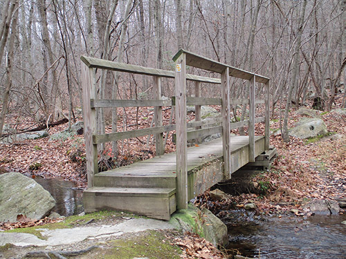
From the kiosk at the western end of the parking area, enter the woods at a triple blaze for the Doris Duke Trail (yellow “DD” logo on white). The trail follows a woods road and soon crosses a wooden footbridge over a stream (built as an Eagle Scout project). About 200 feet beyond the bridge, you’ll notice a sign “DD Loop” on the right. Turn right, leaving the woods road, and head into the woods on a footpath, now following the loop of the Doris Duke Trail in a counterclockwise direction.
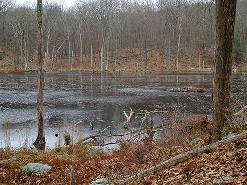
Soon, you’ll pass massive cliffs on the left. A short distance beyond, the trail begins to descend towards a wide marsh. It comes out on a rock outcrop overlooking the marsh, then bears left and continues along the base of the hill, parallel to the marsh.
After joining an old woods road, the trail bears left, leaving the road, and continues on a footpath. The trail curves to the left and begins to climb. It levels off, passes a balanced boulder on the left, then continues a gradual climb, soon joining a wide woods road.
The Doris Duke Trail follows the road uphill towards the crest of the ridge, with several detours to avoid eroded and overgrown sections. As it approaches the crest, the trail bears left and continues on a footpath. Rock steps have been placed in places along this section of the trail to improve the tread for the hiker.
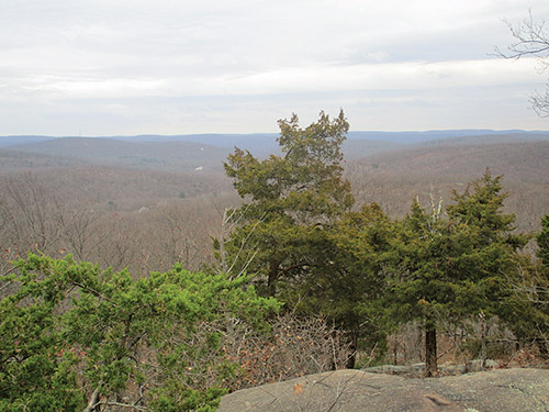
Upon reaching the crest of the ridge, the trail heads southwest along the ridge. Soon, it climbs to a panoramic viewpoint from a rock outcrop (marked by a large cairn). Mombasha Lake may be seen on the left, and the hills of Sterling Forest and Harriman State Park are visible in the distance. This is a good spot to take a break.
Just beyond, you’ll come to a junction with the blue-blazed Allis Trail (also the route of the Highlands Trail). Bear left and continue to head southwest along the ridge, now following both the dark blue blazes of the Allis Trail and the yellow-on-white logo blazes of the Doris Duke Trail.
After a relatively level section, you’ll begin a steady climb and reach the highest point on the ridge (1,386’), marked by several white pines. Unfortunately, there are no views from this high point. The trail now begins to descend, with several steep sections. In about half a mile, you’ll cross a woods road and follow stepping stones across a wet area.
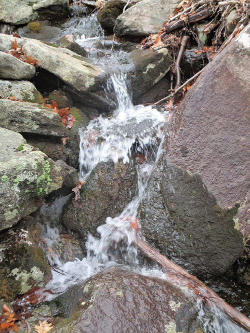
A short distance beyond, the Doris Duke Trail turns left, leaving the Allis Trail. Follow the yellow-on-white Doris Duke blazes, which climb a little and then head downhill, soon reaching an east-facing viewpoint from a rock outcrop with cedar trees. Beyond the viewpoint, the trail descends rock steps and passes lichen-covered rocks on the right. After going by another viewpoint, it continues its steady descent. The trail approaches a stream on the left, with attractive cascades, then curves to the right and goes down to a woods road.
The Doris Duke Trail turns left on the road, but a short distance ahead, it bears left, leaving the road, and soon crosses the stream on stepping stones. It rejoins the road and follows it back to the start of the loop. Turn right and retrace your steps across the footbridge and back to the parking area where the hike began.
This hiking article is provided by Daniel Chazin of the New York-New Jersey Trail Conference. The Trail Conference is a volunteer organization that builds and maintains over 2,000 miles of hiking trails and publishes a library of hiking maps and books, including a map for Sterling Forest Trails ($7.95). The Trail Conference’s office is at 600 Ramapo Valley Road (Route 202), Mahwah; 201-512-9348; www.nynjtc.org. Daniel Chazin can be reached at [email protected].