
This easy-to-moderate, 2.5-mile hike in Hartshorne Woods Park in Monmouth County circles the historic Rocky Point section of the park. During World War II, this area was part of the Atlantic Coast Defense System, with concrete fortifications facing the ocean. The military abandoned the facility in the 1970s, and it is now a county park, but many of the old fortifications still exist.
You’ll also have the opportunity to visit the nearby Twin Lights State Historic Site, which once housed the brightest navigational light in the United States, and to climb a spiral staircase to the top of one of the lighthouse towers. Built in 1862 of local brownstone, the lighthouse was decommissioned in 1949 and was acquired by the state of New Jersey in 1962. For more information, go to www.twinlightslighthouse.org.
The hike should take about two hours, but you’ll want to allow additional time to explore the Twin Lights site as well as Battery Lewis at Hartshorne Woods Park. The buildings at the Twin Lights State Historic Site are open daily (except Monday and Tuesday) from 10:00 a.m. to 4:00 p.m., so it’s a good idea to visit the Twin Lights before doing the hike. Dogs on leash are permitted on the trails in Hartshorne Woods Park.

A map of Hartshorne Woods Park is available online at www.co.monmouth.nj.us/documents/130/Hartshorne-Woods-Brochure-web2022.pdf. The map rates the Rocky Point Trail as “challenging,” but this rating is intended primarily for bicyclists. For hikers, the trail is of no more than moderate difficulty.
To get there from Bergen County, take the New Jersey Turnpike south to Exit 11 and continue on the Garden State Parkway south to Exit 117. Bear left beyond the toll booths and continue on NJ 36 for 13 miles. Just before the Highlands-Sea Bright bridge, turn right at a sign for “Bay Avenue/Highlands.”
To visit the Twin Lights, make the next right onto Highland Avenue. In 0.2 miles, turn left onto Light House Road and follow it to the parking area for the Twin Lights at the top of the hill. GPS address: 2 Light House Road, Highlands, NJ 07732.
To reach the Rocky Point area of Hartshorne Woods Park, continue ahead on Portland Avenue for 0.8 miles to the parking area for Rocky Point (which is straight ahead where the road curves very sharply to the right). GPS address: 1402 Portland Road, Highlands, NJ 07732. The trailhead is about 55 miles from Teaneck, and it should take about 70 minutes to get there.

The Rocky Point Trail in Hartshorne Woods Park is open to hikers, joggers, bicyclists and equestrians, and is often used by bicyclists (although not by equestrians). Park regulations provide that bicyclists must yield to all other trail users, but hikers should be alert for approaching bicycles on narrow trails. Hikers must yield to equestrians.
To begin the hike, which follows the Rocky Point Trail in the clockwise direction, return to the entrance to the parking area and turn right onto a gated but paved park service road. About 50 feet beyond the gate, you will see a signpost on the left marking the start of the Rocky Point Trail.
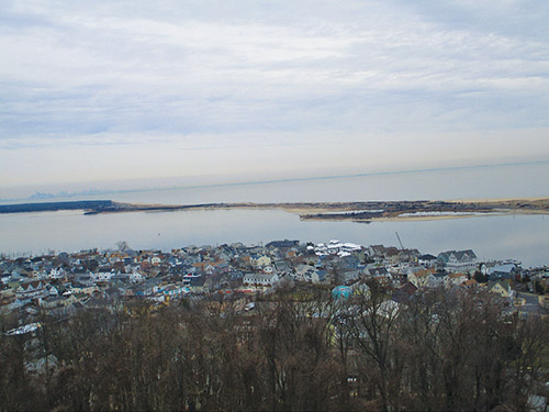
The Rocky Point Trail begins by descending on a winding path through stands of holly to cross a bridge over a stream. It continues through dense vegetation. About half a mile from the start, the trail approaches the Shrewsbury River, with homes on the Sea Bright peninsula visible through the trees across the river.
The trail continues ahead, parallel to the river below on the left, soon reaching a paved service road. To the left, the road leads in 250 feet to a grassy area with picnic tables overlooking the confluence of the Shrewsbury and Navesink rivers—a good place for a break.

Continue ahead on the Rocky Point Trail, which now parallels the Navesink River and begins to climb. At the top of the rise, you’ll notice some ivy-covered trees on the right. The trail descends past a dense stand of holly to reach another paved service road. To the left, this road leads downhill a short distance to the Black Fish Cove fishing pier, with excellent views over the Navesink River (there are also picnic tables and a privy here). The Rocky Point Trail turns right, follows the service road for 50 feet, then turns left and reenters the woods.
The trail descends to cross a footbridge over a small stream, climbs gradually, then levels off. About half a mile from the second service road crossing, it ascends quite steeply. At the top of the climb, where the main trail turns sharply right, follow an unmarked side trail which continues ahead to a limited viewpoint over the Navesink River, with the view largely obscured by the trees. From the viewpoint (shown on the park map as the “Navesink Overlook”), return to the main trail by following a path that heads northeast, then turn left onto the Rocky Point Trail.
The Rocky Point Trail now begins a gradual descent, passing through some dense stands of mountain laurel. About two miles from the start, it crosses another paved service road (to the left, this road leads to an abandoned bunker). The trail now climbs through holly and mountain laurel to cross a small bridge. It descends briefly, continues through dense holly trees, then climbs on switchbacks to reach yet another paved service road—this one marked by two concrete pillars on the left.
Cross the road, then immediately bear right onto a path that heads uphill. You’ll soon reach the crest of the rise and descend to a gravel fire road—the route of the Cuesta Ridge Trail. (Take the right fork just before reaching this junction.) Turn right onto the Cuesta Ridge Trail, then immediately bear right at the next fork. Soon, you’ll reach a paved service road. Turn left on the road, then bear right at the next fork and climb a grassy slope to return to the parking area, which is just ahead.

You will also want to visit Battery Lewis—a large concrete fortification overlooking the ocean, built in 1942. This interesting feature, which features a 68-foot-long, 16-inch caliber gun, is just beyond the parking area, on the left. Interpretive signs explain how and why this imposing fortification was constructed during World War II.
By Daniel Chazin