
This moderate 5.4-mile hike in Fahnestock State Park in Putnam County, New York climbs to an historic iron mine and passes several lakes and waterfalls. Most of the hike is relatively level, but there are a few steep sections. The hike should take about four hours. Dogs are permitted on leash.
To get there from Bergen County, take the Palisades Interstate Parkway north to its terminus at the Bear Mountain Bridge. Cross the bridge and, at the east end of the bridge, turn left and proceed north on N.Y. Route 9D for about 8.5 miles to a junction with N.Y. Route 301 in Cold Spring. Turn right and follow Route 301 for about five miles to Dennytown Road, then turn right and follow Dennytown Road south for 1.1 miles to a dirt parking area on the left side of the road. The trailhead is about 55 miles from Teaneck, and it should take about 70 minutes to get there.
From Westchester County, take the Taconic State Parkway north to Exit 31A and proceed west on N.Y. 301 for 3.6 miles to Dennytown Road. Turn left onto Dennytown Road and proceed south for 1.1 miles to a dirt parking area on the left side of the road.

From the northeast corner of the parking area (to the right of an old stone building) follow the blue-blazed Three Lakes Trail, which enters the woods, crosses a stream on rocks, and bears right to parallel it. After passing a swamp on the right, the trail turns left and begins to climb rather steeply. Near the top of the hill, the trail passes an interesting split rock on the right. Just beyond, the trail curves to the left. Leave the trail here and continue straight ahead.
You’ll soon reach the remains of the Denny Mine. First, you’ll notice a long, narrow opening, surrounded by piles of tailings (waste rock removed from the mine). If you continue a little further to the northeast, you will reach an even more impressive mine opening—about 100 feet long and 20 feet deep, with the bottom filled with water. Use caution in the vicinity of these mine openings.
After proceeding to the north end of the mine, head west. You’ll soon reach a wide, unmarked trail (with some blacked-out blazes). Turn right and follow this trail (actually, a woods road which provided access to the mine when it was in operation). The trail soon bears left and heads downhill through mountain laurel thickets. After looping sharply to the left, the trail reaches Sunken Mine Road (also known as Sunk Mine Road), a rough dirt road. Here, you rejoin the blue-blazed Three Lakes Trail.
Turn right onto Sunken Mine Road and follow it for 500 feet, passing the southern end of John Allen Pond on the left. Just beyond, follow the blue blazes as they turn left, leaving the road. The trail crosses the outlet of the pond on rocks just below an old stone dam (now breached) and turns right. After continuing parallel to the lake shore for a short distance, the trail bears right, away from the lake. It reaches an old mine railbed and turns left to parallel it. After crossing a stream on rocks (to the left, the stone abutments of the mine railway are visible, but the bridge is gone), the trail bears left and joins the mine railbed for a short distance. It then turns left, leaving the railbed, and passes the stone foundations of several buildings from John Allen’s homestead.

The Three Lakes Trail now climbs to reach a junction with the red-blazed Charcoal Burners Trail, which leaves to the left. Proceed ahead on the blue-blazed trail, which goes through mountain laurel thickets and continues through a grassy area, where it crosses a small stream. Just ahead, the yellow-blazed Old Mine Railroad Trail begins on the left. Continue along the blue-blazed Three Lakes Trail, which bears right at a fork and heads north on a relatively level footpath. Soon, you’ll pass Hidden Lake on the left.
About halfway into the hike, you’ll reach a junction (marked by a large cairn) with the white-blazed Appalachian Trail (A.T.). Turn sharply right onto the A.T., which descends, first moderately, then more steeply. At the base of the descent, the A.T. passes a wetland on the right and ascends to the right of a cliff.
The A.T. descends through hemlocks to a level area overgrown with barberry thickets, then bears right to skirt a wetland. At the end of the level area, the A.T. climbs steeply to the top of a ridge covered with mountain laurel, hemlocks and pines. A large boulder in an open area to the right of the trail is a good spot to rest from the steep climb.
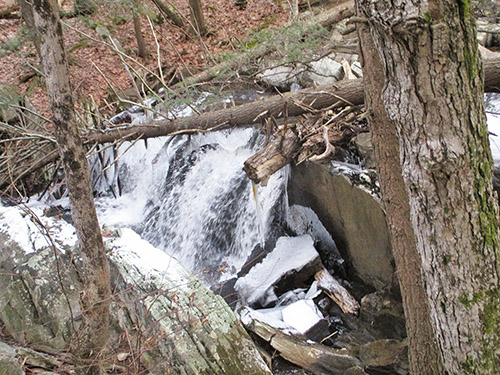
After descending slightly along a rocky ledge, it continues along the ridge, passing through an area with many young pines and hemlocks. At the end of the ridge, the A.T. steeply descends a rocky slope that may be covered with pine needles. This section of the trail can be very slippery, so be sure to exercise caution. A short distance beyond, the trail follows stepping stones over the outlet of a beaver pond to the right of the trail, with a beautiful waterfall immediately downstream.

After a short climb, you’ll reach dirt-and-gravel Sunken Mine Road. The A.T. turns right onto Sunken Mine Road, but it follows the road for only 60 feet before turning left and ascending on an old woods road, first rather steeply, then more gradually. After crossing a long, smooth rock, the trail narrows to a footpath. It descends briefly, then continues to climb to a high point, with limited views through the trees on both sides of the ridge.
The A.T. now begins a steady descent. At the base of the descent, it skirts a swamp on the right, crossing its outlet stream on rocks, and bears right at a fork. In another 0.2 mile you’ll reach the grassy field at Dennytown Road where the hike began.
This hiking article is provided by Daniel Chazin of the New York-New Jersey Trail Conference. Daniel Chazin can be reached at [email protected].