This moderate-to-strenuous 8-mile hike in Harriman State Park (in Orange County, New York) climbs to the summits of Green Pond and Island Pond Mountains, goes through a narrow passage between rocks known as the Lemon Squeezer, reaches the shore of scenic Island Pond, and passes the Boston Mine, a nineteenth century iron mine carved into the hillside. The hike, which should take about five hours, involves a gain of over 1,000 feet in elevation. Dogs are permitted on leash.
To get to the trailhead from Bergen County, take N.J. Route 17 north to the New York State Thruway. Bear left at the fork (following I-87 towards “Albany”) and take the first exit, Exit 15A (Sloatsburg). Turn left at the bottom of the ramp onto N.Y. Route 17 north, and continue for 10.5 miles, passing through the villages of Sloatsburg, Tuxedo and Southfields. About 3 miles north of the intersection with Route 17A, turn right onto Arden Valley Road at a sign for “Harriman State Park.” In 0.3 mile, at a sign for the “Elk Pen Hikers Lot,” turn right and park in the parking area. The trailhead is about 30 miles from Teaneck, and it should take about 45 minutes to get there.
From the east side of the parking area, follow the white-blazed Appalachian Trail (A.T.) across the meadow. At the end of the meadow, bear right and head south for about 100 feet, where you will see a wooden sign on the left giving mileages along the A.T.
Turn left to continue along the A.T., which begins a steady ascent of Green Pond Mountain on a moderate grade. As it approaches the summit, it curves to the right and climbs rather steeply on stone steps, then bears left and climbs more gradually on switchbacks. At the summit, a large boulder to the left of the trail affords limited west-facing views. You’ve climbed over 500 vertical feet to reach this point. After a relatively level stretch, the A.T. descends the eastern slope of the mountain on a rocky footpath, with a set of stone steps along the way.
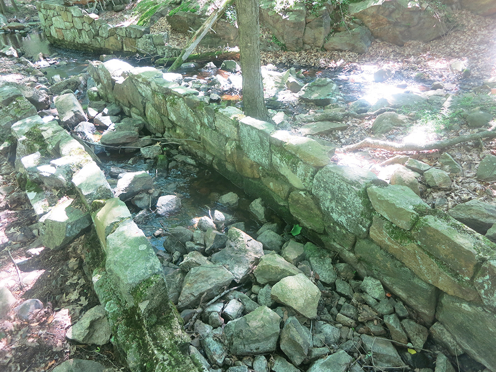
At the base of the descent, the A.T. turns left onto Island Pond Road, a dirt road built by Edward Harriman about 1905. In 500 feet, it turns right, goes over a small rise, crosses a gravel road, and descends to cross an outlet of the pond on a short wooden bridge. The adjacent stone spillway was built by Civilian Conservation Corps workers in the mid-1930s.
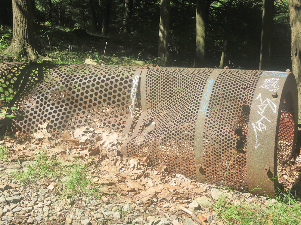
The A.T. now ascends to a knoll, with a limited view of Island Pond. On the way, you’ll pass a cylindrical rusted metal object on the right. This was a rotary gravel sorter, used to separate different sizes of gravel. The trail then descends and turns right on another woods road, known as the Crooked Road. In a short distance, follow the A.T. as it turns left and climbs to a junction with the Arden-Surebridge (A-SB) Trail, marked with red triangles on a white background. Bear left at the junction and follow the joint A.T./A-SB a short distance to the base of a large rock formation, where the two trails split.
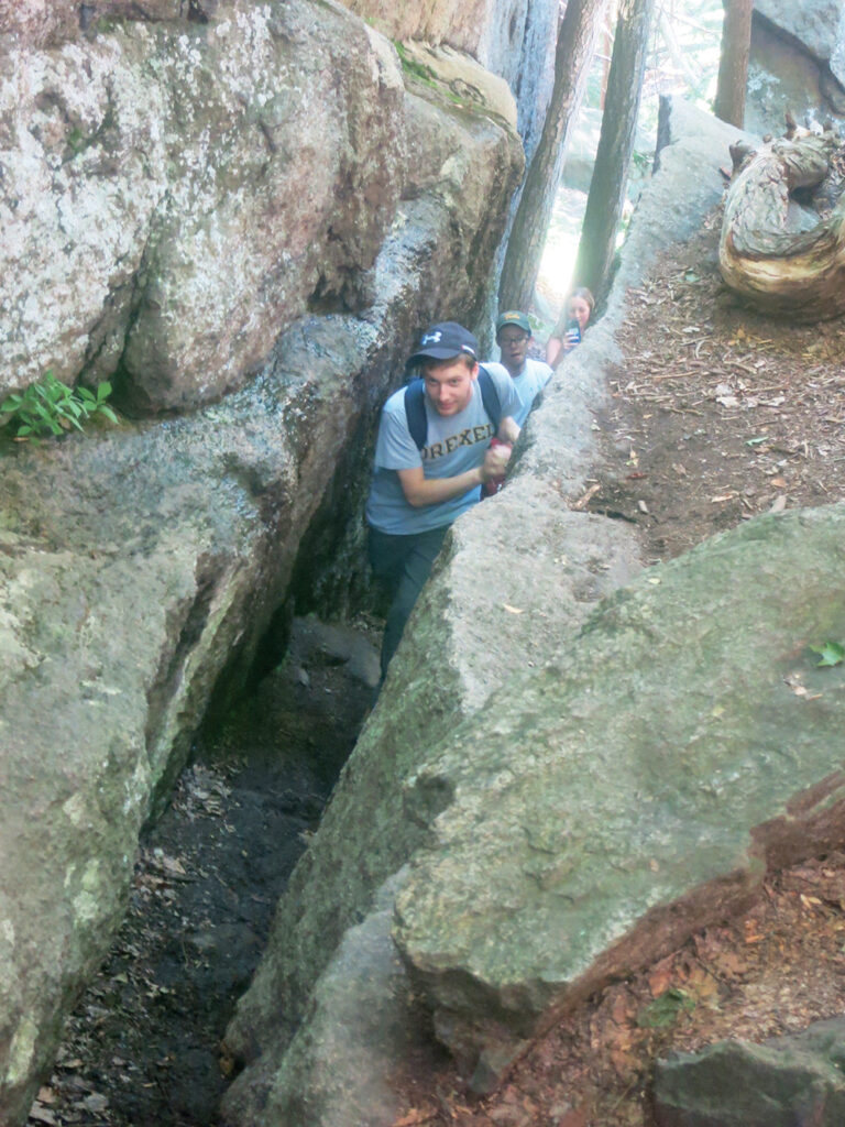
This rock formation, known as the Lemon Squeezer, is one of the most interesting features of the park. Turn left and follow the A.T. as it climbs through a very narrow passage between rocks and then goes up a steep rock face, where you will need to use both your hands and your feet. (If the climb is too difficult, you can bypass it by following a path to the left.)
The A.T. continues on a more moderate grade to the summit of Island Pond Mountain. It then descends, soon entering a hemlock grove. After winding through the hemlocks and crossing a stream, you’ll reach a junction with the aqua-blazed Long Path, marked by a wooden signpost. Turn right, leaving the A.T., and follow the Long Path as it skirts the edge of the Dismal Swamp. The ridge visible across the swamp to the left (east) is Surebridge Mountain.
A short distance beyond the outlet of the swamp, crossed on tree roots, you’ll come to a woods road—the route of the A-SB Trail. Turn left onto the road, but in 50 feet, turn right onto the White Bar Trail (marked by horizontal white blazes), which continues through an area with many ferns and young trees. In a quarter mile, it turns left onto a woods road—the continuation of the Crooked Road that you followed earlier in the hike. The White Bar Trail climbs gently through a wide valley, then levels off.
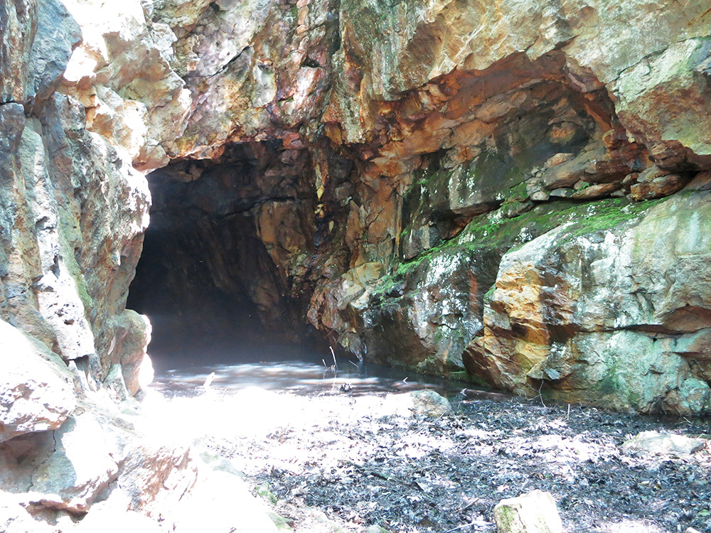
A short distance beyond, the yellow-blazed Dunning Trail joins from the left. Bear right, now following both white and yellow blazes. When the two trails separate in a quarter mile, turn right and follow the yellow blazes of the Dunning Trail. After passing a massive cliff on the right, the trail descends to a col, ascends a rise, and descends to the base of the Boston Mine. This iron mine—a large open cut into the hillside, partially filled with water—is reached by a short path to the right. It was last worked around 1880.
After visiting this mine, continue ahead on the yellow-blazed Dunning Trail. In 500 feet, you’ll reach a wide woods road—the southern end of Island Pond Road. Turn right, leaving the yellow-blazed trail, and follow the unmarked Island Pond Road as it descends through hemlocks and laurels towards Island Pond. When you briefly encounter the red-triangle-on-white blazes of the A-SB Trail, proceed ahead, bearing right at the fork, and follow an unmarked woods road that heads towards the southern tip of Island Pond.
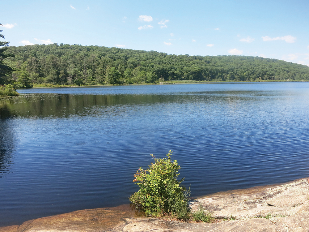
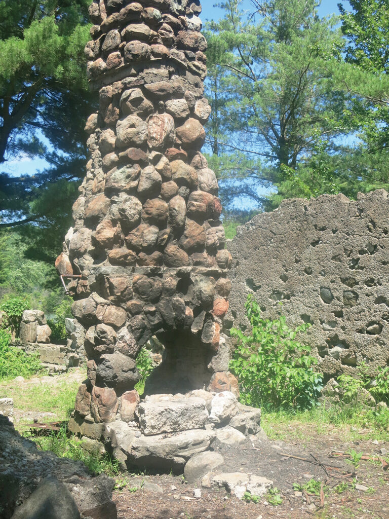
After passing through mountain laurel and evergreens, you’ll arrive at the ruins of a stone building, built by the park as a ranger station. Just beyond, a rock ledge affords an expansive view over scenic Island Pond.
When you’re ready to continue, retrace your steps along the road to the junction with the A-SB Trail. This time, bear right and follow the A-SB as it heads west, crossing the southern outlet of Island Pond and passing through a region where young hemlocks, pines and deciduous trees are revegetating an area damaged by a forest fire. Just beyond, a short side trail on the right leads to open rocks, with limited views through the trees to the west and north.
The A-SB Trail now turns right and begins to run along a ledge, with a fairly steep drop on the left. After passing by an overhanging rock, it turns sharply left and begins a rather steep descent. At the base of the steep descent, it crosses a stream, turns right and climbs a little, then levels off. Soon, it again begins to descend, but on a more moderate grade.
After crossing another stream on rocks, you’ll reach a woods road—the Old Arden Road—at the base of the descent (the road here has narrowed to a footpath). Turn right and continue to follow the A-SB Trail northward along the road. In a third of a mile, the A.T. joins from the right and the A-SB Trail ends. Bear left and follow the A.T. across the meadow back to the Elk Pen parking area, where the hike began.
This hiking article is provided by Daniel Chazin of the New York-New Jersey Trail Conference. The Trail Conference is a volunteer organization that builds and maintains over 2,000 miles of hiking trails and publishes a library of hiking maps and books. The Trail Conference’s office is at 600 Ramapo Valley Road (Route 202), Mahwah; (201) 512-9348; www.nynjtc.org. Daniel Chazin can be reached at [email protected].