


This rugged, figure-eight, double-loop hike climbs two peaks at the southern end of Norvin Green State Forest—Torne Mountain and Osio Rock. Although it is just under three miles long, the hike may seem somewhat longer, as it involves considerable ups and downs on rocky trails. But it traverses a less-used area of this popular park, and it features a series of panoramic views of the surrounding peaks and (on a clear day) the New York City skyline. The hike should take about three hours, and dogs are permitted on leash.
To get there, take Route 4 West to Route 208, and continue on Route 208 to I-287 South. Take Exit 53 (Bloomingdale) and turn left onto Hamburg Turnpike. Upon entering Bloomingdale, the name of the road changes to Main Street. In 1.3 miles (from I-287), you’ll reach a fork in the road. Bear right, and in another 0.1 miles, bear right (uphill) onto Glenwild Avenue. Continue ahead for 3.2 miles to a parking area on the right side of the road, just beyond a “Welcome to Bloomingdale” sign. If this parking area is full, continue ahead for 0.2 miles to another parking area on the right. Both of these parking areas can fill up on weekends, so one should get an early start or do this hike on a weekday.
To begin the hike, cross Glenwild Avenue at the eastern end of the first parking area. On the south side of the road, you’ll see a sign for the Hewitt-Butler Trail. Follow this blue-blazed trail, which climbs the hill and then turns right, heading west and parallel to the road on a rugged footpath, for a quarter mile. Here, with the road visible to the right, you’ll cross the red-blazed Torne Trail.
Continue ahead on the blue-blazed Hewitt-Butler Trail, which begins a steady climb of Torne Mountain. In about 15 minutes, you’ll come out on a open rock ledge, with limited views to the west and north. When there are no leaves on the trees, Buck Mountain is visible to the north.
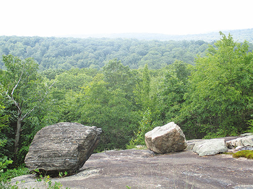
Proceed ahead, following the blue blazes along the ridge of Torne Mountain. After crossing several open areas with west-facing views, you’ll arrive at a large open area with two cedar trees, two balanced glacial erratics and a stone bench. This beautiful spot affords unobstructed views to the west and south.
The trail now begins to descend. Soon, you’ll reach a junction with a black-dot-on-blue side trail. Here, you should turn left to stay on the blue-blazed trail. Just ahead, you’ll come to a southeast-facing viewpoint over Osio Rock (the next peak you will climb), with the New York City skyline visible in the distance on a clear day. After descending some more, you’ll come to another view of Osio Rock. The trail now descends along the side of a hill, with Osio Rock visible to the left along the way. After a rather steep descent, the trail levels off.
Just beyond, you’ll pass the other end of the black-dot-on-blue side trail and descend into a ravine with an intermittent stream. The red-blazed Torne Trail crosses here, but you should turn right to stay on the blue-blazed Hewitt-Butler Trail. Follow the blue-blazed trail, which climbs through dense thickets of mountain laurel, levels off, then resumes its climb.
After passing a jumbled formation of huge boulders on the right, the trail again briefly levels off, then resumes a steady climb to reach a limited east-facing viewpoint. A short distance beyond, it emerges onto a rock ledge—the summit of Osio Rock. This peak affords a spectacular 270-degree view. The large body of water visible on the left is the Wanaque Reservoir. You’ll want to take a break here to rest from your climb and enjoy the views.
When you’re ready to continue, follow the blue blazes as the trail descends from Osio Rock. On the way down, you’ll pass a southeast-facing viewpoint over the private Lake Kampfe and then a west-facing viewpoint over a rocky peak studded with pines. The trail now descends more steeply on a rocky footpath. After a short level stretch, the blue-blazed Hewitt-Butler Trail ends, just before a stream, at a junction with the red-blazed Torne Trail.
Turn right onto the Torne Trail, which heads north on a level footpath parallel to the stream, then begins to climb through a ravine. In a third of a mile, you’ll once again cross the blue-blazed Hewitt-Butler Trail. Continue ahead on the red-blazed Torne Trail, which climbs steeply through large boulders, then continues to ascend on a gentle grade through an attractive valley.
The Torne Trail descends from the crest of the rise, again crosses the blue-blazed Hewitt-Butler Trail, and ends just before reaching Glenwild Road. Turn right onto Glenwild Road and follow it for a short distance to the parking area where the hike began.
This hiking article is provided by Daniel Chazin of the New York-New Jersey Trail Conference. The Trail Conference is a volunteer organization that builds and maintains over 2,000 miles of hiking trails and publishes a library of hiking maps and books. The Trail Conference’s office is at 600 Ramapo Valley Road (Route 202), Mahwah; (201) 512-9348; www.nynjtc.org. Daniel Chazin can be reached at [email protected].