


Silas Condict County Park is a little-known gem in northeastern Morris County that can be reached from Teaneck in only about 30 minutes. This 2.5-mile moderate hike follows the White Trail, which loops around the park. It climbs to several panoramic viewpoints, passes a balanced rock and goes through a ‘rock tunnel.” Because of the rather rugged terrain that the hike traverses, it will probably take you about two and a half hours to cover the distance. Dogs are welcome on leash. Maps may be available at a kiosk near the start of the hike, but you can also download a map at www.morrisparks.net.
To reach the park, take N.J. Route 4 to Route 208, and follow Route 208 North to I-287 South. Take Exit 52B (N.J. Route 23 North) of I-287, and follow Route 23 north for 2.6 miles. Take the exit for Kinnelon Road/Kiel Avenue, and turn left at the traffic light onto Kiel Avenue south. After crossing Route 23, continue for 1.1 miles to the entrance to Silas Condict County Park, on the right. Turn right and follow William Lewis Arthur Drive (the park entrance road) for 0.7 mile, passing two parking areas and a locked gate on the right. With the lake and a stone building (known as the Casino) visible on the left, park in the third parking area along the road. (If the third parking area is full, go back to the second parking area and park there.)
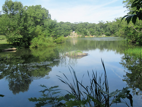
From the third parking area, head south, passing to the right of the lake and the Casino. Continue ahead on a gravel road, passing a ballfield on the right. At the end of the lake, the road curves sharply left. In another 350 feet (before reaching a chain-link fence across the road), you’ll notice a kiosk and a triple-white blaze on a tree to the right. This marks the start of the White Trail, which will be your route for the entire hike.
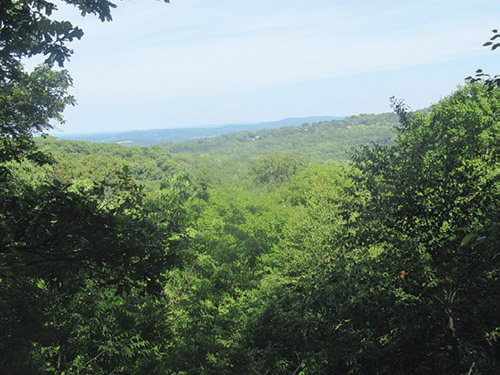
Turn right and follow the White Trail into the woods. It climbs to the edge of an escarpment, descends a little, then resumes a steady climb. Be alert for a sharp turn to the right. Just ahead, the trail switches back to the left and begins a steeper climb. At the crest of the rise, the trail comes out on a rock outcrop, with a panoramic east-facing view. A wooden bench has been placed here to permit you to rest and enjoy the view.
Just ahead, the trail begins a steady descent, passing interesting rock outcrops on the way down. At the base of the descent, the Yellow Trail begins on the right. The White Trail climbs again, first gradually, then more steeply on a rocky path through mountain laurel thickets. At the top, the trail turns sharply left. Here, a rock outcrop just ahead on the ridge, with pitch pines, offers a broad view to the west.
After taking in the view, backtrack for about 25 feet, turn right and continue through dense mountain laurel thickets. The trail soon climbs back to the ridge and heads south, following a rugged route, with several short but steep ups-and-downs, and limited views to the west through the trees. Pay careful attention to the blazes, as there are several herd paths that lead in the wrong direction. Toward the end of the ridge, the trail descends a little, then comes out onto a broad southwest-facing viewpoint from a rock ledge to the right of the trail.
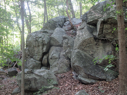
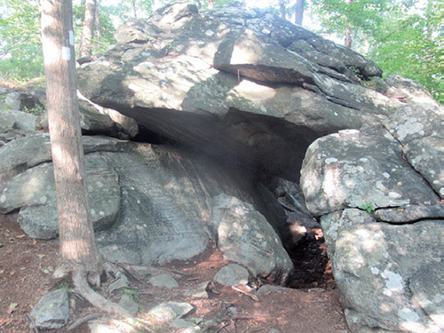
The trail levels off, then climbs to pass a balanced boulder on the right. It descends a rocky slope, then levels off. After passing a fractured rock outcrop on the right, the trail begins a short ascent. At the top of the climb, it turns right and goes through an interesting “rock tunnel,” passing under massive boulders. It now climbs past a huge rock outcrop and again starts to descend.
After crossing open rock outcrops the trail turns left, passes a huge overhanging boulder on the right and levels off. It soon reaches a kiosk (and a nearby bench) that marks the terminus of the Yellow Trail, which comes in from the right. Just ahead, the trail begins a gradual descent. After crossing an intermittent stream, it makes a short climb. The trail passes a massive rock outcrop on the left, then descends more steeply. It goes over another rise and descends to cross a tributary stream on a wooden bridge.
After crossing Trout Brook on another wooden bridge, the trail steeply climbs around a cliff, turns left onto a gravel road, and continues to climb rather steeply, passing a wooden bench along the way. It reaches an open area at the crest of the rise, where it bears left, leaving the gravel road, and continues on a footpath. Soon, you’ll pass rock outcrops on the left that offer a west-facing view overlooking the ridge that you followed at the start of the hike.
The trail now descends, twice briefly joining dead-end branches of the gravel road that it followed up the rise. It continues on a footpath to end at the second parking area of the park. Turn left to return to the third parking area, where the hike began.
This hiking article is provided by Daniel Chazin of the New York-New Jersey Trail Conference. The Trail Conference is a volunteer organization that builds and maintains over 2,000 miles of hiking trails and publishes a library of hiking maps and books, including a four-map set for Kittatinny Trails ($13.95). The Trail Conference’s office is at 600 Ramapo Valley Road (Route 202), Mahwah; (201) 512-9348; www.nynjtc.org. Daniel Chazin can be reached at [email protected].