This four-mile, easy-to-moderate hike loops around Tourne Park in Morris County, New Jersey. It climbs to the top of the Tourne and follows an old railroad grade, passing an interesting wetland. The hike should take about two-and-a-half hours. A map is available online at www.morrisparks.net. Dogs are permitted on leash.
To get there, take I-80 to Exit 43 (Mahwah/Morristown/I-287), then take Exit 43B onto I-287 North. Take the first exit, Exit 43 (Intervale Road), and turn left at the top of the ramp. Cross over I-287 and turn right at the traffic light onto Fanny Road. At the second stop sign, reached in 0.9 mile, continue ahead, following the sign to “West Main Street,” then bear left at the next fork onto County Route 618. In 0.2 mile, at a sign for “Tourne County Park,” turn left onto McCaffrey Lane and proceed for 0.5 mile to a parking area at the end of the road. GPS address: 48 McCaffrey Lane, Boonton, NJ 07005. The trailhead is about 30 miles from Teaneck, and it should take about 40 minutes to get there.
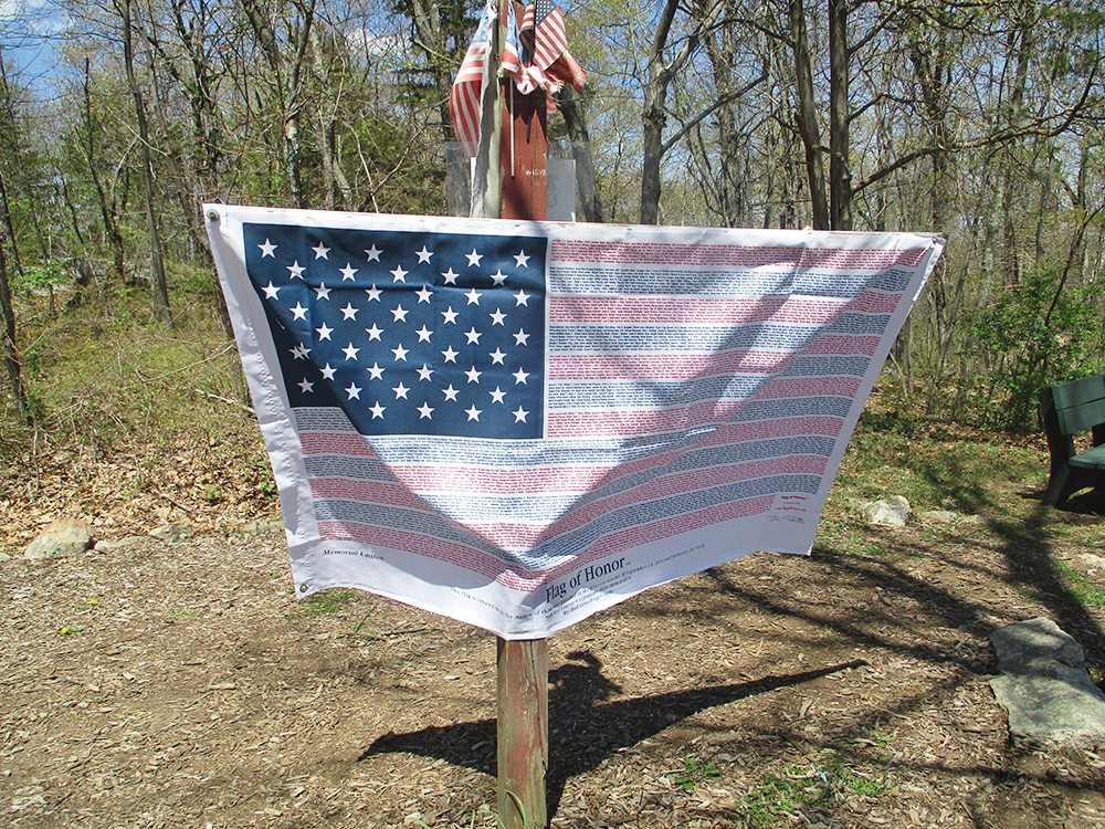
From the parking area, walk back along the entrance road until, at a curve to the right in the entrance road, a paved road blocked by a gate continues ahead. (There is a sign here for the Wildflower Area.) Follow this road past the gate and you’ll soon reach a four-way junction. Continue ahead on a wide, yellow-blazed gravel road that climbs on a moderate grade to the top of the Tourne. Along the way, you’ll cross the Orange Trail. Near the top, you’ll notice a special flag, placed as a memorial to the tragic 9/11 terrorist attack on the World Trade Center. In 2001, the Twin Towers of the World Trade Center were visible from here, but unfortunately, the view has grown in, and you can no longer see the New York City skyline from this point.
Just ahead, a grassy clearing on the left with picnic tables, marks the high point of the Tourne (897 feet), with a limited west-facing view. Continue ahead on the gravel road, which descends steadily, passing interesting rock formations on the hillside to the left, and once again crossing the Orange Trail.
As the road curves to the left near the base of the descent, look carefully for a footpath that goes off sharply to the right. Although (at this writing) no blazes are visible at this junction, you should turn sharply right onto the footpath, the route of the Orange Dot Trail (black dot on orange). The first part of this trail is very sparsely blazed, but the footpath is clear and obvious. Follow the Orange Dot Trail as it continues to descend gradually on switchbacks, soon passing a playground on the left.

With the park maintenance center visible ahead, the trail turns right onto a gravel road. As of this writing, there are purple (rather than orange dot) blazes here, and you should follow the purple blazes, which continue ahead on a footpath at the turnaround of the gravel road. Then, with Norris Road visible ahead, the trail curves to the left and soon begins to climb. In half a mile, the trail crosses the park entrance road and follows a trail section built by an AmeriCorps trail crew of the Trail Conference in 2021. Soon, the purple blazes end, and the orange dot blazes resume. In another 500 feet, the Pink Trail begins on the left, but you should continue to follow the Orange Dot Trail, which climbs gently. After curving to the left, the Orange Dot Trail crosses the Red Trail and begins a gradual descent.
The Orange Dot Trail again curves to the left and ends at a junction with the Purple Trail. Turn right onto the Purple Trail, which passes under a canopy of winged euonymus (also known as “burning bush”). In a quarter mile, after climbing a little, the Purple Trail ends at a junction with the Red Trail near a vernal pond. Turn left onto the Red Trail, and in 100 feet, turn right to continue on the Red Trail as the Purple Dot Trail (black dot on purple) proceeds straight ahead. The Red Trail now climbs slightly to a ridge that overlooks a ravine below on the left.
After descending once more, you’ll come to a junction (marked by a sign for the Tourne), where you should turn left. Once again, the trail runs along the edge of a ridge, overlooking the opposite side of the ravine. It then descends, bears left at a fork, and reaches a five-way intersection, where you should turn left onto the White Trail (following a sign for “Tourne Access”).
Built in 1899 by Clarence DeCamp as part of a planned railroad between Boonton and Denville and 10 years later proposed as the route of a trolley line to connect these two municipalities, the route of the present-day White Trail was graded but never completed as a railroad (or trolley line). The White Trail soon passes a small concrete building on the right and crosses a wetland. Here, the graded trail is only a few inches above the wetland, so it can be wet after heavy rains. After a while, the trail follows a strip of land that is raised a few feet above the surrounding terrain, paralleling Rigby’s Brook on the right and crossing several tributary streams on wooden bridges.

In half a mile, you’ll pass a viewpoint over Rattlesnake Meadow on the right. A short distance beyond, a wooden post on the right indicates the start of an unmarked trail that leads down to Rattlesnake Meadow and crosses it. (This trail may be flooded during wet periods.) Just beyond, the Pink Trail begins on the left. After curving to the right, the White Trail ends, one mile from its start, on a gated section of the park entrance road. Turn right and follow the park entrance road back to the parking lot where the hike began.
This hiking article is provided by Daniel Chazin of the New York-New Jersey Trail Conference. The Trail Conference is a volunteer organization that builds and maintains over 2,000 miles of hiking trails and publishes a library of hiking maps and books. The Trail Conference’s office is at 600 Ramapo Valley Road (Route 202), Mahwah; (201) 512-9348; www.nynjtc.org. Daniel Chazin can be reached at [email protected].