


This 3.8-mile moderate hike in Ramapo Valley County Reservation follows the yellow-blazed Vista Loop Trail, blazed in 2016 by volunteers of the New York-New Jersey Trail Conference. It climbs to several viewpoints, passes a rock ledge with clumps of cactus, and goes by a waterfall. The hike should take about two and one-half hours. Dogs are allowed on leash.
To get there, take N.J. Route 17 North to U.S. Route 202 in Mahwah. Turn left at the bottom of the ramp, proceed south on Route 202 for 2.0 miles, and turn right into the Ramapo Valley County Reservation parking area.
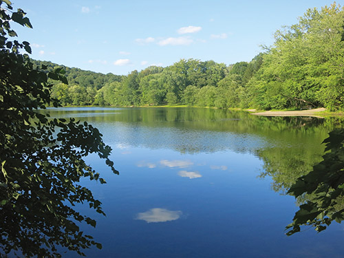
The hike begins at a kiosk in the southwest corner of the parking area. Just ahead, you’ll notice a triple-yellow blaze on a tree, which marks the start of the Vista Loop Trail. Follow the yellow blazes as they descend wooden steps, join a wide dirt road, and continue ahead to cross the Ramapo River on a steel truss bridge. In another 250 feet, the green-dot-on-orange-blazed River Trail begins on the left, but you should continue ahead on the wide dirt road, following the yellow blazes along the southern shore of Scarlet Oak Pond.
At the end of the pond, you’ll notice a sign for the “Yellow Vista Loop,” with arrows pointing in both directions. Here, a triple-blue blaze marks the start of the Ridge Trail. Continue ahead on the wide dirt road to follow the Vista Loop Trail in the counterclockwise direction. In another 125 feet, turn right, continuing to follow the yellow blazes of the Vista Loop Trail. Just ahead, a triple silver-on-white blaze marks the start of the Pond Loop Trail. Continue ahead, parallel to the western shore of the pond, now following both yellow and silver-on-white blazes.
In 500 feet, follow the Vista Loop Trail as it turns sharply left, leaving the wide dirt road and the Pond Loop Trail, and crosses a wooden footbridge. The Vista Loop Trail now begins to climb on a moderately steep grade. After a short level stretch, followed by a brief climb over a rock outcrop, it arrives at Hawk Rock. This east-facing ledge offers an expansive view over much of Bergen County, with Ramapo College in the foreground on the left. Lake Henry is directly ahead, with Scarlet Oak Pond to the south (right).
The Vista Loop Trail now bends to the left and continues to ascend, bearing left at a fork just ahead. After a steep, rocky climb, the trail levels off and soon emerges on an open rock ledge, with a panoramic east-facing view. The view from this Cactus Ledge is even broader than that from Hawk Rock, with the New York City skyline visible on the horizon on a clear day. You’ll notice several clumps of prickly pear cactus—the only native American cactus that grows east of the Rocky Mountains. You’ve climbed about 400 vertical feet to reach this spectacular viewpoint, so you’ll want to take a break here.
When you’re ready to continue, follow the yellow blazes as they turn right, and reenter the woods at the southern end of the viewpoint. Soon, the Vista Loop Trail joins another footpath that comes in from the right. A short distance ahead, you’ll reach a junction. Here, a triple-green-on-white blaze marks the start of the Halifax Trail, which leaves to the right, but you should bear left to continue on the Vista Loop Trail.
The Vista Loop Trail continues to climb gradually. Near the crest of the rise, the trail briefly joins an old woods road. It bears right, climbs a little more, then levels off, with some minor ups and downs.
In half a mile, after crossing a low stone wall, the Vista Loop Trail reaches a T-intersection with a woods road. Here, the White Trail begins on the right, but you should turn left to continue on the yellow-blazed Vista Loop Trail. In 500 feet, the blue-blazed Ridge Trail joins from the right. Follow the coaligned yellow and blue trails for another 500 feet, then turn right to continue on the yellow-blazed Vista Loop Trail.
In 200 feet, the Vista Loop Trail turns right, but you should bear left and continue on a wide path, marked with green-dot-on-yellow blazes, that leads a short distance to a panoramic southeast-facing viewpoint from a rock ledge. Campgaw Mountain may be seen in the foreground to the right, and the New York skyline is visible in the distance on a clear day.
After taking in the view, retrace your steps to the yellow-blazed trail and turn left, following the trail as it descends steadily. Just before reaching a large pile of boulders, the trail turns right and climbs to a rocky outcrop, from which Matty Price Hill is visible ahead. The trail now descends towards the MacMillan Reservoir, passing another rocky outcrop (with a view of Matty Price Hill) along the way.
Soon, you’ll emerge on a large expanse of open rock that overlooks the reservoir. Here, the pink-blazed Reservoir Loop Trail joins from the right. You should turn left and head southeast, following both yellow and pink blazes parallel to the shore of the reservoir. You’ll pass the concrete-and-stone dam at the southeast corner of the reservoir and continue downhill to reach a junction with the main park road, where the pink-blazed Reservoir Trail ends and the blue-blazed Ridge Trail joins from the right.
Continue ahead and proceed downhill along the road, now following both blue and yellow blazes. Just before reaching a wide bridge over a stream (the outlet of the reservoir), at a sign for the “waterfall,” follow the Vista Loop Trail as it turns right, leaving the road. (The blue-blazed Ridge Trail continues ahead on the road.)
The yellow-blazed trail now begins to parallel the stream, with its attractive cascades and pools. Soon, it begins to descend on stone steps, passing an attractive waterfall along the way. This beautiful trail section was built in 2017-18 by an AmeriCorps trail crew of the New York-New Jersey Trail Conference. At the base of the descent, the Vista Loop Trail turns left and crosses the stream on a wooden footbridge.
Just ahead, the Vista Loop Trail bears left, as the green-dot-on-orange-blazed River Trail begins on the right. Follow the yellow-blazed trail for another quarter mile to a wide dirt road, where the loop ends. Turn right and continue along the wide dirt road parallel to the southern shore of Scarlet Oak Pond, then proceed across the bridge over the Ramapo River and climb steps to reach the parking area where the hike began.
This hiking article is provided by Daniel Chazin of the New York-New Jersey Trail Conference. The Trail Conference is a volunteer organization that builds and maintains over 2,000 miles of hiking trails and publishes a library of hiking maps and books. The Trail Conference’s office is at 600 Ramapo Valley Road (Route 202), Mahwah; (201) 512-9348; www.nynjtc.org. Daniel Chazin can be reached at [email protected].


