
This issue of The Jewish Link marks the fifth anniversary of the publication of my first hike in the Link on August 23, 2019. To commemorate this special occasion, I’ve decided to rerun the same hike, as updated to reflect current conditions.
This moderate 2.4-mile loop hike, in the Boroughs of Rockleigh and Alpine in northeast Bergen County, climbs the western slope of the New Jersey Palisades. It parallels the scenic Roaring Brook and passes two historic stone cisterns that once provided water to homes below. The hike involves a total elevation gain of about 500 feet, and it should take about one-and-a-half hours to complete the loop. Dogs are permitted on leash. A map is available online at www.nynjtc.org/map/rockleigh-woods-lamont-reserve-trail-map.
The hike traverses two preserved tracts on the western slope of the New Jersey Palisades—the 84-acre Rockleigh Woods Sanctuary, located in the Borough of Rockleigh, which purchased it in 1975, and the 134-acre Lamont Reserve, located in the Borough of Alpine, and purchased jointly by the County of Bergen, the Borough of Alpine and the Borough of Rockleigh in 1996. Both tracts were formerly part of Camp Alpine of the Greater New York Councils, Boy Scouts of America.
To get there, take the Palisades Interstate Parkway to Exit 4. Turn left at the bottom of the ramp onto Route 9W (if coming from the north, turn right onto Route 9W) and proceed for 1.1 miles, entering New York. At the next traffic light, turn left onto Oak Tree Road and, in 0.2 mile, turn left onto Closter Road. In 0.5 mile, after crossing under the Parkway, you reenter New Jersey, and the road becomes Rockleigh Road. Continue for another 0.2 mile to the Rockleigh Municipal Building and turn left into the driveway (opposite Willow Avenue). Park in the rear of the building. GPS address: 26 Rockleigh Road, Rockleigh, NJ 07647. The trailhead is about 17 miles from Teaneck (via the above route; it can also be accessed via local streets) and it should take about 25 minutes to get there.
From the parking area, follow a sidewalk past several picnic tables to a kiosk, which marks the start of the blue-blazed Hutcheon Trail. Follow this trail into an area with dense low vegetation.
As the trail enters the woods, you’ll notice triple-yellow blazes on trees to the right and to the left. Turn right and follow the yellow-blazed Sneden-Haring-Lamont Trail, which heads south, then turns right at a T-intersection and descends to cross a brook on a culvert. To the right is the site of the former Sneden Ice Pond (now overgrown with vegetation). The trail now turns left and continues to head south, soon crossing a small stream on rocks.
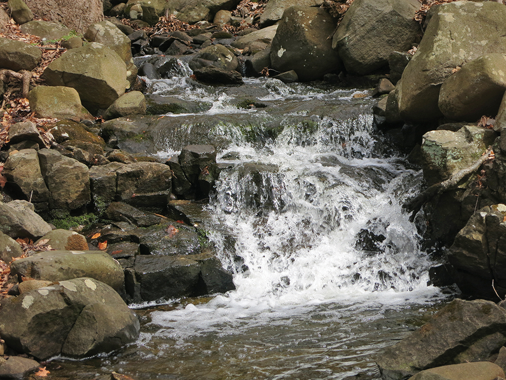
A short distance ahead, the blue-blazed Hutcheon Trail joins from the left, and both trails cross the wide Roaring Brook on rocks. This crossing can be tricky if the water is high, but the water can be very low during dry periods. On the other side, turn left, following the blue blazes, which parallel the brook. Soon, you’ll notice a triple-orange blaze, which marks the start of the Brook Connector Trail, on a tree to the right. Turn left and follow this trail, which heads uphill on a gradual grade, paralleling the scenic Roaring Brook, with views of the brook below. (When the water is high, there are attractive cascades and pools in the brook.)
After climbing along the brook for a quarter mile, the Brook Connector Trail ends at a junction with the white-blazed Lamont Rock Trail. Turn right onto this trail, which descends briefly, then bears left, crosses an old, eroded woods road and a small stream, and continues to descend through an area with many trees toppled during Hurricane Sandy in 2012. After descending some more, the Lamont Rock Trail is joined from the right by the blue-blazed Hutcheon Trail.
Just ahead, the Hutcheon Trail ends, and the yellow-blazed Sneden-Haring-Lamont Trail joins from the left. In 50 feet, where the two trails diverge, turn left and continue to follow the white blazes.
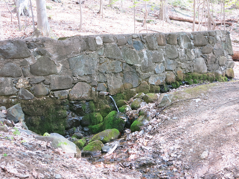
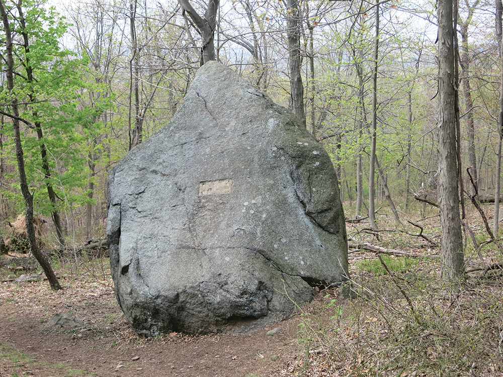
The Lamont Rock Trail now climbs steadily, soon passing two old stone cisterns. It continues to climb to Lamont Rock (a huge boulder), on the left. Just beyond, the white trail turns left and climbs very gently to the highest point in the preserve (480 feet), with a limited east-facing view. (The Hudson River can be seen through the trees during leaf-off season.)
The white-blazed Lamont Rock Trail now begins to descend. In a short distance, turn left at a T-intersection to continue along the white trail. In 0.2 mile, the yellow-blazed Sneden-Haring-Lamont Trail joins from the left.
A short distance beyond, where the two trails diverge, bear right and follow the yellow-blazed trail along a wide woods road, crossing Roaring Brook on rocks. (A crude log/plank bridge on the left, built by bikers, can be used if the water is high.) Just beyond, turn left onto the red-on-white-blazed Roaring Ravine Trail and follow it as it descends along the north side of the brook. At the base of the descent, the Roaring Ravine Trail ends at a junction with the blue-blazed Hutcheon Trail. Turn right onto the blue-blazed trail, which descends gradually, crossing two stone bridges over brooks, and follow it back to the parking area where the hike began.
This hiking article is provided by Daniel Chazin of the New York-New Jersey Trail Conference. The Trail Conference is a volunteer organization that builds and maintains over 2,000 miles of hiking trails and publishes a library of hiking maps and books. The Trail Conference’s office is at 600 Ramapo Valley Rd.,(Route 202), Mahwah; (201) 512-9348; www.nynjtc.org. Daniel Chazin can be reached at dchazin@aol.com.


