
This 4.2-mile moderate-to-strenuous lollipop-loop hike climbs to the summit of Storm King Mountain in Orange County, New York, with panoramic views both north and south over the Hudson River. Although no part of the hike is particularly difficult, the hike involves a total ascent of about 1,000 vertical feet. The hike should take about three hours, and dogs are permitted on leash. The route of the hike is shown on Map 113 of the Trail Conference’s West Hudson Trails map set. A free map (somewhat difficult to read) is available online at https://parks.ny.gov/documents/parks/StormKingTrailMap.pdf
Originally named “Boterberg” (Butter Hill) by the Dutch colonists of the region, the mountain was renamed “Storm King” in the middle of the 19th century by writer Nathaniel Parker Willis, who explained: “The tallest mountain is… looked upon as the most sure foreteller of a storm. When the white cloud-beard descends upon his breast in the morning… there is sure to be a rain-storm before night.” New York physician Ernest Stillman donated the park’s initial 800 acres to the Palisades Interstate Park Commission in 1922. Since then, the park has grown to nearly 2,000 acres.
To get there from Bergen County, take the Palisades Interstate Parkway north to its terminus at the Bear Mountain Circle and continue north on US 9W for 9.0 miles. About half a mile after passing a parking area marked with a blue sign, turn right onto Mountain Road. Follow Mountain Road for 0.8 mile to a small parking area on the right side of the road, in front of stone walls and pillars. GPS address: 185 Mountain Road, Cornwall-On-Hudson, NY 12520. The trailhead is about 50 miles from Teaneck, and it should take about 60 minutes to get there.*
From the parking area on Mountain Road, proceed uphill on a wide gravel road, following the yellow blazes of the Stillman Trail. In about half a mile, after crossing a stone-arch bridge, the trail turns left, leaving the gravel road. Just before reaching a north-facing viewpoint over the Hudson River, the teal-diamond-blazed Highlands Trail joins from the left.
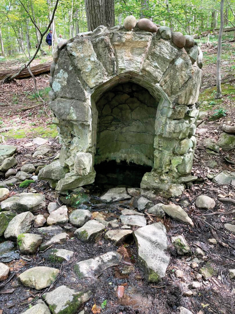
The joint Stillman/Highlands Trail now begins to climb on a footpath. With the gravel road just to the right, the trail turns sharply left and continues to climb. At the next sharp left turn, a triple red/blue blaze on a tree to the left marks the start of the red/blue-blazed Bluebird Trail. (A small stone spring house may be seen just below this intersection.) Turn right onto the Bluebird Trail, which follows around the side of a hill, then climbs gently. After turning left onto a woods road, the trail climbs rather steeply on switchbacks. This is the steepest section of the hike—you gain about 350 feet in elevation in only 0.3 mile. After passing a limited west-facing viewpoint from a rock ledge, the Bluebird Trail ends at a junction with the Stillman/Highlands Trail (yellow and teal diamond blazes).
Turn left, uphill, and continue on the Stillman/Highlands Trail. A short distance ahead, you’ll reach the northern end of the blue-blazed Howell Trail, which leaves to the right. Bear left here, continuing along the yellow/teal diamond-blazed trail, which follows a relatively level route. After a short, steep climb, you’ll reach a limited view to the northwest. The Moodna Viaduct on Metro-North’s Port Jervis Line is directly ahead, with Schunemunk Mountain to its left. A few minutes ahead, after climbing a little more, you’ll come to a viewpoint looking north over the Hudson River. North and South Beacon Mountain are to the right, and the Newburgh-Beacon Bridge is visible in the distance.
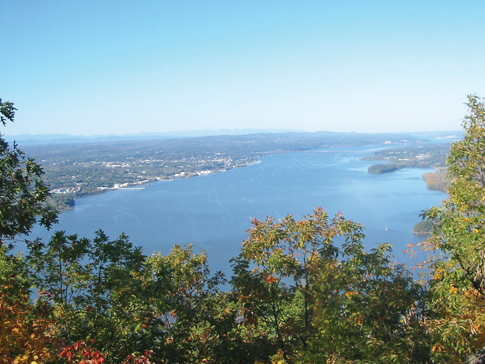
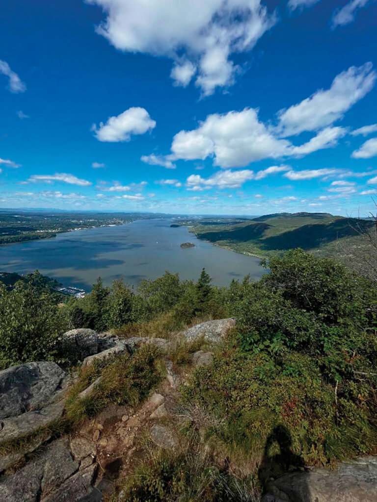
Proceed ahead, and climb to the summit of Storm King Mountain. Just beyond, you’ll come to a broad but somewhat obstructed north-facing viewpoint, with a good view of the Newburgh-Beacon Bridge spanning the Hudson River. Continue ahead for a short distance, and you’ll come to a panoramic, largely unobstructed viewpoint over the Hudson River, with superb views. Pollepel Island, with the ruins of Bannerman’s Castle, is directly below. To the east, Breakneck Ridge (marked by a rail tunnel) is visible across the river. The stone building at the foot of Breakneck Ridge caps a shaft of the Catskill Aqueduct, which tunnels over 1,100 feet below the river (views of both the rail tunnel under Breakneck Ridge and the stone building at its foot may be obstructed by vegetation). North Beacon Mountain (with communications towers) and South Beacon Mountain (with a fire tower) are to the northeast, and the Newburgh-Beacon Bridge crosses the river in the distance. Beyond, the Shawangunks and Catskills can be seen on a clear day. To the left, the village of Cornwall is below, along the west bank of the river. The rail line running along the east shore of the Hudson is Metro-North’s Hudson Line (also the route of Amtrak trains to Albany).
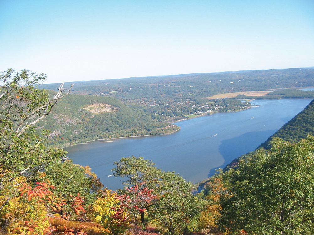
The Stillman/Highlands Trail now continues to descend, soon reaching a junction with the white-blazed By-Pass Trail. Continue along the yellow/teal diamond-blazed Stillman/Highlands Trail, which turns sharply left, immediately reaching a panoramic viewpoint from rock ledges on the right. This viewpoint faces south, with the village of Cold Spring visible across the river to the southeast, and Constitution Island jutting into the river just beyond. Even better views can be had from rock ledges a little further along the trail.
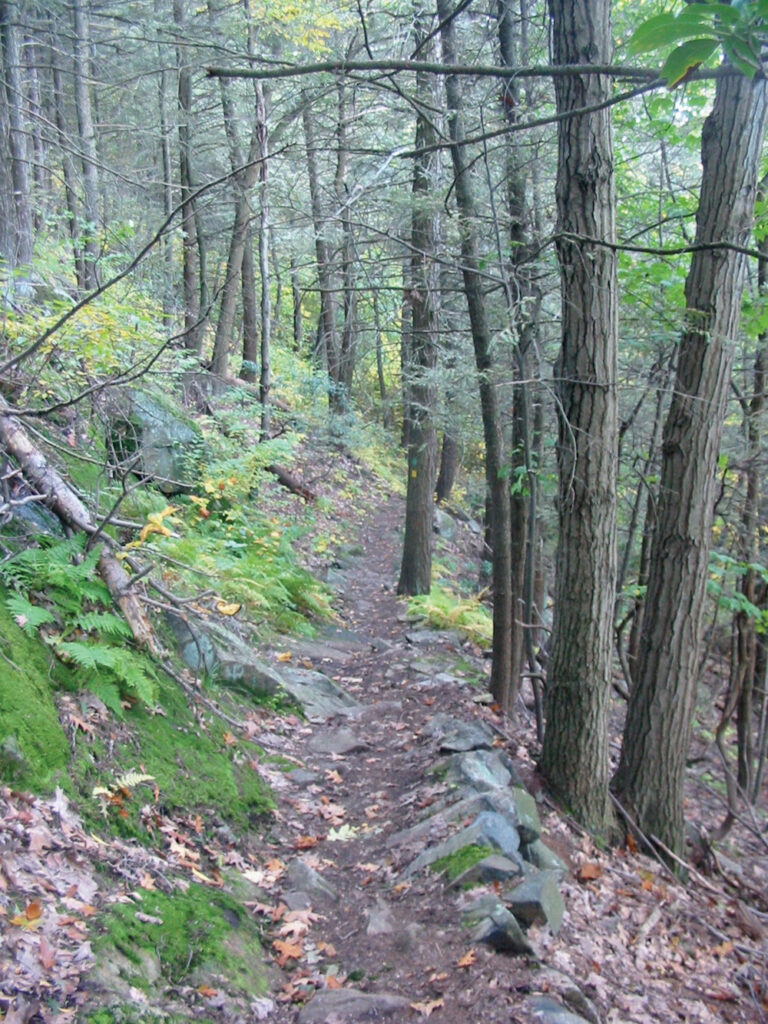
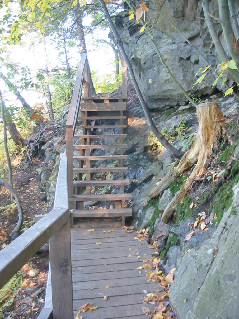
Soon, the Stillman/Highlands Trail bears left and descends along a beautiful stretch of sidehill trail. This narrow trail is quite rocky and can be slippery when wet, so use caution. After passing another panoramic viewpoint to the north, the trail descends on a switchback. About a third of a mile further on, the trail goes down another switchback and crosses a wooden bridge (with steps) over a steep drop at the edge of a cliff.
Shortly thereafter, you’ll reach the junction with the Bluebird Trail that you encountered earlier in the hike. Turn right and continue to follow the yellow-blazed Stillman Trail, retracing your steps back to the parking area where the hike began. Note that the Stillman and Highlands Trails diverge just past the north-facing viewpoint, so be sure to continue on the correct trail (if you parked on Mountain Road, you need to bear left and continue on the Stillman Trail; if you parked at the Esty & Hellie Stowell Trailhead, you should continue downhill on the Highlands Trail).
This hiking article is provided by Daniel Chazin of the New York-New Jersey Trail Conference. The Trail Conference is a volunteer organization that builds and maintains over 2,000 miles of hiking trails and publishes a library of hiking maps and books. The Trail Conference’s office is at 600 Ramapo Valley Road (Route 202), Mahwah; (201) 512-9348; www.nynjtc.org. Daniel Chazin can be reached at DChazin@aol.com.
*If the small parking area is full (roadside parking is not allowed), continue ahead on Mountain Road for another 0.9 mile to its terminus on Hudson Street (Route 218). Turn right, and bear right onto Bayview Avenue where Dock Hill Road begins on the left. Continue for 0.2 mile to a sign for the “Esty & Hellie Stowell Trailhead.” Turn right at the sign and proceed to a parking area at the end of the road. From the parking area, head uphill on the Highlands Trail (teal diamond blazes) until you reach a junction with the yellow-blazed Stillman Trail. Turn left and follow the joint Stillman/Highlands Trail, which immediately reaches a north-facing viewpoint (continue by following directions below).


