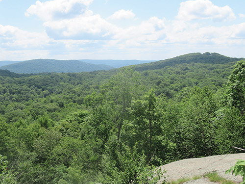


The northern section of Norvin Green State Forest is little used, yet it offers some great hiking. This 4.7-mile hike, which passes several panoramic overlooks and follows the yellow-blazed Manaticut Point Loop, which is accessed via the Manaticut Point Spur Trail. The hike should take about three-and-a half hours.
To get there, take NJ Route 4 West and continue on Route 208 West, which becomes I-287 South. Take Exit 57 and turn right onto Skyline Drive. Continue on Skyline Drive to its northwestern terminus at Greenwood Lake Turnpike (county Route 511). Turn left and proceed south for 1.6 miles to West Brook Road. Turn right onto West Brook Road and cross the Wanaque Reservoir on a causeway. At the next T-junction, turn left and proceed for 0.8 mile to Magee Road. Turn right onto Magee Road and take the first left onto Burnt Meadow Road. Continue for 0.9 mile and turn left at the second intersection with Crescent Drive. Continue for 0.2 mile until you reach a huge boulder and a kiosk on the right side of the road, just beyond a curve. Ample roadside parking is available along Crescent Drive. GPS address: 1 Crescent Drive, Ringwood, NJ 07456.
Between the boulder and the kiosk, a triple black-square-on-yellow blaze marks the start of the Manaticut Point Spur Trail. Head into the woods on this trail. Soon, you’ll cross two branches of a stream on rocks, with several abandoned sections of concrete pipe adjacent to the stream, and pass by a huge fractured rock. A short distance beyond, you’ll cross another stream.
After crossing a third stream below an interesting inverted-V-shaped rock formation and proceeding through an area with an understory of ferns, the Manaticut Point Spur Trail ends at a junction with the yellow-blazed Manaticut Point Loop. Here, the yellow blazes head both to the left and straight ahead. You should continue straight ahead, uphill (toward Lake Sonoma), to follow the loop of the Manaticut Point Loop in the counterclockwise direction.
About a mile from the start, you’ll pass the trailhead of the orange-blazed Lake Sonoma Trail on the right. A short distance ahead, you’ll notice a triple yellow/orange blaze on the left, but you should continue ahead on the yellow-blazed Manaticut Point Loop, which descends to cross the inlet stream of Lake Sonoma at a woods road, immediately turns right and soon reaches a limited viewpoint over the lake. The trail reenters the woods, with views of the lake through the trees, then bears right and reaches a panoramic viewpoint over the lake. Soon, it bears sharply left and heads away from the lake, following a narrow ridge, then turns right onto a woods road.
The Manaticut Point Loop soon turns left and away from the woods road. It briefly parallels a stream, then crosses it below an attractive cascade. The trail immediately turns sharply left, briefly joining another woods road, then bears right and begins a steady climb. At the top, it bears left, briefly descends, then turns sharply left at a switchback and climbs gently to reach a junction with the white-blazed Overlook Rock Trail, which joins from the right.
Continue ahead, now following both yellow and white blazes. In 150 feet, both trails turn right at a double blaze. Here, you should turn left and make a short, steep climb up a rock ledge, emerging onto Overlook Rock—a massive exposed rock face. Overlook Rock affords a panoramic east-facing view over Lake Sonoma and Windbeam, Bear and Board Mountains, with the Ramapo Mountains in the background. You’ve now gone about two miles from the start.
After taking in the view, descend from the rock and turn left onto the white/yellow-blazed trail. In half a mile, after crossing an intermittent stream and climbing gradually, you’ll reach a junction (marked by a single cedar tree) with the blue-blazed Hewitt-Butler Trail at a limited viewpoint to the southwest.
Turn left, now following both yellow and blue blazes. The trail descends briefly, then climbs steeply to the crest of the ridge. It heads southeast along the ridge, passing viewpoints on the right over Saddle Mountain and then descending gradually. At the base of the descent, there is a small pond on private property to the right.
After climbing through a cleft in the rock, you’ll pass the southern end of the yellow/orange-blazed connector trail on the left. Continue along the blue/yellow-blazed trail, which descends a little and then climbs steadily to a panoramic viewpoint from Manaticut Point—an open rock ledge. Windbeam Mountain is directly ahead (east). To the south, you can see a quarry, with the New York City skyline visible on the horizon on a clear day (the best view of the city is from the rock ledge to the right of the one traversed by the trail).
The trail now descends very steeply. Watch carefully for a double blaze painted on a rock. Here, the blue-blazed Hewitt-Butler Trail turns right, but you should follow the yellow-blazed Manaticut Point Loop, which turns left and continues to descend more gradually. The trail soon bears left and climbs a little, goes through an interesting passage between rocks, then resumes a steady descent. After passing several rock formations on the left and crossing a stream, it climbs to the junction where the Manaticut Point Loop ends. Bear right and follow the black-square-on-yellow blazes of the Manaticut Point Spur Trail, retracing your steps to the trailhead on Crescent Drive, where the hike began.
This hiking article is provided by Daniel Chazin of the New York-New Jersey Trail Conference. The Trail Conference is a volunteer organization that builds and maintains more than 2,000 miles of hiking trails and publishes a library of hiking maps and books. The Trail Conference’s office is at 600 Ramapo Valley Road (Route 202), Mahwah; (201) 512-9348; www.nynjtc.org. Daniel Chazin can be reached at DChazin@aol.com.


